more stats
1,995 ft
Distance
-204 ft
Descent
00:03:42
Avg time
-205 ft
Altitude change
1,764 ft
Altitude min
1,969 ft
Altitude max
1,969 ft
Altitude start
1,765 ft
Altitude end
-10.3%
Grade
-21.7%
Grade max
1%
Grade min
1,804 ft
Distance down
187 ft
Distance flat
00:03:42
Avg time

Fully Rigid Details

  • Activities
    • Mountain Bike
    • Hike
    • Trail Running
  • Riding Area
    Tiger Mountain State Forest
    Issaquah, Washington
  • Difficulty Rating
  • Voted Difficulty
    Black Diamond (5 votes)
  • Local Popularity
    70 in Mountain Biking [+]
    • 40 in Trail Running
    • 50 in Hiking
  • Global Ranking
    #34678 in Mountain Biking [+]
    • #120343 in Trail Running
    • #114808 in Hiking
  • Trail Type
    Singletrack
  • Bike Type
    AM
  • Direction
    Downhill Primary
    Popular Direction Shown
  • Climb Difficulty
    Black Diamond
  • Physical Rating
    Moderate
  • Dogs Allowed
    Yes
  • eBike Allowed
  • TTFs on Trail
    Rock Garden, Other
  • Ride in Rain
    Yes
  • Land Owner
    Washington State DNR

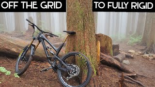
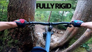
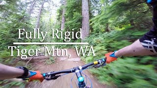
Gnarly, rocky, rooty goodness, but still has some good flow to it too. Solid single black. The crux, especially when wet, is navigating the "v-tree" root ball about halfway down without dabbing.

Ride it twice for a nice extra loop: Ride down Fully Rigid, go left at the trail junction to ride Silent Swamp trail in North direction, then ride the Crossover Road back up to Fully Rigid and ride it again, this time continuing Right at the junction, across the bridge and onto Joy Ride trail, then out to Northwest Timber and the parking lot.

Local Trail Association
Traditionally Indigenous Territory

Recent Activity on Trail

Past Week
  • 12 rides
  • 13 miles average
6 Months
  • 103 rides
  • 12 miles avg distance
All
  • 2,648 rides
  • Last: Jun 4, 2026
c1c2c3c4
January
February
March
April
May
June
July
August
September
October
November
December
update trails status or condition

Fully Rigid Trail Reports

statusdatedescription
May 27, 2026 @ 9:20pm (America/Los_Angeles)
May 27, 2026
Mar 22, 2026 @ 10:28am (America/Los_Angeles)
Mar 22, 2026
tree down about 500 ft from trailhead. About 10" diameter
Jan 21, 2026 @ 10:18am (America/Vancouver)
Jan 21, 2026
It just doesn’t get any better! [L=https://www.evergreenmtb.org/trails/ride-reports/rr-9456]Evergreen MTB Report[/L]
Dec 22, 2025 @ 9:53pm (America/Los_Angeles)
Dec 22, 2025
Tree down halfway in
Oct 27, 2025 @ 11:15am (America/Los_Angeles)
Oct 27, 2025
more »
Status:
on May 27, 2026
Avg: 3.38 (71 votes)
Your vote: 0

view (13,625)
close
3D
Trail Conditions
  • Unknown
  • Snow Groomed
  • Snow Packed
  • Snow Covered
  • Snow Cover Partial
  • Freeze/thaw Cycle
  • Icy
  • Prevalent Mud
  • Wet
  • Variable
  • Ideal
  • Dry
  • Very Dry
Trail Flow (Ridden Direction)
Trailforks scans users ridelogs to determine the most popular direction each trail is ridden. A good flowing trail network will have most trails flowing in a single direction according to their intension.
The colour categories are based on what percentage of riders are riding a trail in its intended direction.
  • > 96%
  • > 90%
  • > 80%
  • > 70%
  • > 50%
  • < 50%
  • bi-directional trail
  • no data
Trail Last Ridden
Trailforks scans ridelogs to determine the last time a trail was ridden.
  • < 2 days
  • < 1 week
  • < 2 weeks
  • < 1 month
  • < 6 months
  • > 6 months
Trail Ridden Direction
The intended direction a trail should be ridden.
  • Downhill Only
  • Downhill Primary
  • Both Directions
  • Uphill Primary
  • Uphill Only
  • One Direction
Contribute Details
Colors indicate trail is missing specified detail.
  • Description
  • Photos
  • Description & Photos
  • Videos
Trail Popularity ?
Trailforks scans ridelogs to determine which trails are ridden the most in the last 9 months. Trails are compared with nearby trails in the same city region with a possible 25 colour shades. Think of this as a heatmap, more rides = more kinetic energy = warmer colors.
  • most popular
  • popular
  • less popular
  • not popular
ATV/ORV/OHV Filter
Max Vehicle Width
inches
US Cell Coverage
Legend
cell carrier legend

Radar Time
Activity Recordings
Trailforks uses anonymized public activity data. ?
Activity Recordings
Trailforks uses anonymized public activity data. ?
Personal Heatmap
Activity Types
all / none
Options
2
Date range month
Winter Trails
Warning A routing network for winter maps does not exist. Selecting trails using the winter trails layer has been disabled.
Missing Trails
Most Popular
Least Popular
Trails are colored based on popularity. The more popular a trail is, the more red. Less popular trails trend towards green.
Jump Magnitude Heatmap
Heatmap of where riders jump on trails. Zoom in to see individual jumps, click circles to view jump details.
BC Backroad Status

Service Road Atlas is a free to use, community-driven service for viewing and creating reports on the numerous back-country service roads around B.C. and Alberta.

map legend
Slope Aspect
Direction the slope faces
Flat N NE E SE S SW W NW
Trails Deemphasized
Trails are shown in grey.
disable
Only show trails with no bike usage.
Enable
Suggested Layers
Based on selected activity type

    Save the current map location and zoom level as your default home location whenever this page is loaded.

    Save
        Directions to fully-rigid trailhead (47.484910, -121.920170)

        Photos

        10 more »
        426 |
        Sep 2, 2020 @ 8:53pm
        Sep 2, 2020
        552 |
        May 17, 2014 @ 1:10pm
        May 17, 2014
        1,403 |
        Sep 21, 2015 @ 9:57pm
        Sep 21, 2015
        28 |
        Mar 22, 2026 @ 10:28am
        Mar 22, 2026

        Videos

        4 more »
        off the grid
        15:39 | 430 | Jan 28, 2022 , Issaquah
        FULLY RIGID // TIGER MOUNTAIN // BLACK DIAMOND
        3:08 | 966 | May 30, 2021 , Issaquah
        Fully Rigid - Tiger Mtn MTB
        1787 | Oct 1, 2016 , Issaquah
        First Time at Tiger Mountain
        0:46 | 360 | Sep 13, 2015 , Issaquah

        Trail Lists

        Routes with this trail

        4.4 10 miles 1,955 ft 6 Loop
        This is the standard Tiger lap from the top. From either parking lot, take the and trails and then the...
        5.0 7 miles 1,567 ft 6 Loop
        Lunch length loop that gets in a couple of good downhills and mostly avoids the service roads.
        4.0 13 miles 2,328 ft 7 Loop
        Back in the day, we only had , and . The old classic loop would have been to climb Main Tiger, descend and...

        4 Reviews & Comments


        We hope you've been enjoying Trailforks!

        Create a FREE account to view trail comments and much more.

        • By jebikeTF Pro & contributors
        • #17241 - 9,929 views

        Frequently Asked Questions About Fully Rigid

        Where is Fully Rigid located?
        Fully Rigid is located in Tiger Mountain State Forest, Issaquah, Washington, United States. It is part of the Tiger Mountain State Forest trail network. The trailhead is located at coordinates 47.48491, -121.92017.
        How hard is Fully Rigid?
        Fully Rigid is rated as Black Diamond difficulty. The physical rating is Moderate. The average grade is 10.3%. The climb difficulty is rated Black Diamond.
        What is the elevation gain for Fully Rigid?
        The trail has 204 ft of elevation descent. The elevation ranges from 1,764 ft to 1,969 ft.
        Is Fully Rigid a point to point trail?
        Fully Rigid is not a point to point trail. The direction is Downhill Primary. The trail type is singletrack.

        Hit the Trail

        Open in App

        Get this trail on your phone instantly.
        open trail in app

        Download Trail

        Save to wishlist, Garmin & download.
        save the trail

        Find Related Routes

        Find routes and users activities that include this trail.
        find routes for this trail

        You must enter a description before submitting.