more stats
1.9 miles
Distance
106 ft
Climb
-108 ft
Descent
1,744 ft
High Point
1,700 ft
Altitude min
1,744 ft
Altitude start
1,745 ft
Altitude end
-7.2%
Grade max
10.6%
Grade min
2,615 ft
Distance climb
2,900 ft
Distance down
4,341 ft
Distance flat

Galcial Erratic Details

  • Activities
    • Mountain Bike
    • E-Bike
    • Winter Fat Bike
    • Hike
    • Trail Running
  • Riding Area
    WinMan Trails
    Manitowish Waters, Wisconsin
  • Difficulty Rating
  • Local Popularity
    80 in Mountain Biking [+]
    • 70 in E-Biking
    • 5 in Trail Running
    • 5 in Hiking
  • Global Ranking
    #189434 in Mountain Biking [+]
    • #323628 in Hiking
  • Hiking SAC Scale
    T1 Hiking
  • Trail Type
    Singletrack
  • Bike Type
    AM, XC, Fat
  • Direction
    One Direction
  • Climb Difficulty
    Blue
  • Physical Rating
    Moderate
  • Trail Visibility
    Always easy to follow
  • Dogs Allowed
    Yes
  • eBike Allowed
    Yes up to Class 1
  • TTFs on Trail
    Drop, Jump, Rock Garden
  • Land Owner
    WinMan Trails

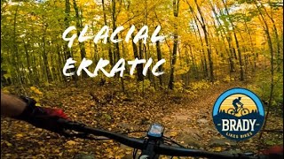
Clocking in at just under 1.5 miles, this trail grabs your attention and holds it. With constants twists, climbs, rock features, and descents - this once keeps you on your toes (and off your seat) the entire time.

While we do have a full loop, Glacial Erratic is not fully complete. We'll finish an additional section in 2025 that will add about another mile to continue to challenge and excite all who ride it.

REMINDER: Unlike the vast majority of trails at WinMan, this one was built without ride arounds. If you approach a rock feature you are not confident on, simply walk it and set your goal to conquer it next time.

Local Trail Association

Recent Activity on Trail

Past Week
  • 1 rides
  • 14 miles average
6 Months
  • 8 rides
  • 15 miles avg distance
All
  • 83 rides
  • Last: Jun 22, 2026
c1c2c3c4
January
February
March
April
May
June
July
August
September
October
November
December
update trails status or condition

Galcial Erratic Trail Reports

statusdatedescription
May 27, 2026 @ 8:37am (America/Chicago)
May 27, 2026
reporter Open for the summer!
May 5, 2026 @ 6:52pm (America/Chicago)
May 5, 2026
reporter hoping to open mid may
May 5, 2026 @ 6:51pm (America/Chicago)
May 5, 2026
reporter
Jun 17, 2025 @ 12:25pm
Jun 17, 2025
Oct 12, 2024 @ 9:26pm
Oct 12, 2024
Riding GREAT! Rode it on Friday before the rain and it was wonderful. Had one loose sandy corner that almost sniped me, but otherwise it was...
more »
Status:
on May 27, 2026
Ideal
Avg: 5 (1 votes)
Your vote: 0

view (456)
close
3D
Trail Conditions
  • Unknown
  • Snow Groomed
  • Snow Packed
  • Snow Covered
  • Snow Cover Partial
  • Freeze/thaw Cycle
  • Icy
  • Prevalent Mud
  • Wet
  • Variable
  • Ideal
  • Dry
  • Very Dry
Trail Flow (Ridden Direction)
Trailforks scans users ridelogs to determine the most popular direction each trail is ridden. A good flowing trail network will have most trails flowing in a single direction according to their intension.
The colour categories are based on what percentage of riders are riding a trail in its intended direction.
  • > 96%
  • > 90%
  • > 80%
  • > 70%
  • > 50%
  • < 50%
  • bi-directional trail
  • no data
Trail Last Ridden
Trailforks scans ridelogs to determine the last time a trail was ridden.
  • < 2 days
  • < 1 week
  • < 2 weeks
  • < 1 month
  • < 6 months
  • > 6 months
Trail Ridden Direction
The intended direction a trail should be ridden.
  • Downhill Only
  • Downhill Primary
  • Both Directions
  • Uphill Primary
  • Uphill Only
  • One Direction
Contribute Details
Colors indicate trail is missing specified detail.
  • Description
  • Photos
  • Description & Photos
  • Videos
Trail Popularity ?
Trailforks scans ridelogs to determine which trails are ridden the most in the last 9 months. Trails are compared with nearby trails in the same city region with a possible 25 colour shades. Think of this as a heatmap, more rides = more kinetic energy = warmer colors.
  • most popular
  • popular
  • less popular
  • not popular
ATV/ORV/OHV Filter
Max Vehicle Width
inches
US Cell Coverage
Legend
cell carrier legend

Radar Time
Activity Recordings
Trailforks uses anonymized public activity data. ?
Activity Recordings
Trailforks uses anonymized public activity data. ?
Personal Heatmap
Activity Types
all / none
Options
2
Date range month
Winter Trails
Warning A routing network for winter maps does not exist. Selecting trails using the winter trails layer has been disabled.
Missing Trails
Most Popular
Least Popular
Trails are colored based on popularity. The more popular a trail is, the more red. Less popular trails trend towards green.
Jump Magnitude Heatmap
Heatmap of where riders jump on trails. Zoom in to see individual jumps, click circles to view jump details.
BC Backroad Status

Service Road Atlas is a free to use, community-driven service for viewing and creating reports on the numerous back-country service roads around B.C. and Alberta.

map legend
Slope Aspect
Direction the slope faces
Flat N NE E SE S SW W NW
Trails Deemphasized
Trails are shown in grey.
disable
Only show trails with no bike usage.
Enable
Suggested Layers
Based on selected activity type

    Save the current map location and zoom level as your default home location whenever this page is loaded.

    Save
        Directions to galcial-erratic trailhead (46.188890, -89.879950)

        Photos

        No photos have been added for Galcial Erratic yet, add a photo.

        Videos

        1 more »
        WinMan Trails Glacial Erratic
        12:33 | 55 | Nov 10, 2024 , Manitowish Waters

        Reviews / Comments

        No reviews yet, be the first to write a review or ask a question.
        Use trail reports to comment on trail conditions.


        We hope you've been enjoying Trailforks!

        Create a FREE account to view trail comments and much more.

        • By alfotschTF Pro Winman & contributors
        • #796182 - 241 views

        Frequently Asked Questions About Galcial Erratic

        Where is Galcial Erratic located?
        Galcial Erratic is located in WinMan Trails, Manitowish Waters, Wisconsin, United States. It is part of the WinMan Trails trail network. The trailhead is located at coordinates 46.18889, -89.87995.
        How hard is Galcial Erratic?
        Galcial Erratic is rated as Blue difficulty. The physical rating is Moderate. The climb difficulty is rated Blue.
        What is the elevation gain for Galcial Erratic?
        Galcial Erratic has 106 ft of elevation gain. The trail has 108 ft of elevation descent. The elevation ranges from 1,700 ft to 1,744 ft.
        Is Galcial Erratic a point to point trail?
        Yes, Galcial Erratic is a point to point trail. The direction is One Direction. The trail type is singletrack.

        Hit the Trail

        Open in App

        Get this trail on your phone instantly.
        open trail in app

        Download Trail

        Save to wishlist, Garmin & download.
        save the trail

        Find Related Routes

        Find routes and users activities that include this trail.
        find routes for this trail

        You must enter a description before submitting.