more stats
4,272 ft
Distance
93 ft
Climb
-335 ft
Descent
00:06:05
Avg time
-242 ft
Altitude change
4,946 ft
Altitude min
5,188 ft
Altitude max
5,188 ft
Altitude start
4,948 ft
Altitude end
-5.7%
Grade
-43.6%
Grade max
30.2%
Grade min
981 ft
Distance climb
2,969 ft
Distance down
318 ft
Distance flat
00:06:05
Avg time

Gang Gangs Details

  • Activities
    • Mountain Bike
    • E-Bike
    • Hike
    • Trail Running
  • Riding Area
  • Difficulty Rating
  • Voted Difficulty
    Blue (1 vote)
  • Local Popularity
    95 in Mountain Biking [+]
    • 95 in E-Biking
    • 65 in Trail Running
    • 5 in Hiking
  • Global Ranking
    #24636 in Mountain Biking [+]
    • #3401 in E-Biking
    • #81925 in Trail Running
    • #81335 in Hiking
  • Trail Exposure
    High Risk
  • Trail Type
    Singletrack
  • Bike Type
    AM, XC
  • Direction
    Downhill Only[+]
    Popular Direction Shown
    • Downhill Only for E-Biking
    • Downhill Only for Trail Running
    • Downhill Only for Hiking
  • Climb Difficulty
    Blue
  • Physical Rating
    Moderate
  • Trail Visibility
    Always easy to follow
  • Alpine Trail
    Yes
  • eBike Allowed
    Yes up to Class 1
  • TTFs on Trail
    Berm, Bridge, Jump, Rock Garden
  • Ride in Rain
    Yes
  • Land Owner
    Alpine Resorts Victoria

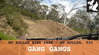
Grab your gang and hit up the fast and flowy Gang Gangs. Freshly sculpted berms, huge rollers and jumps, Gang Gangs is everything that’s good about Mountain Biking packed into one trail.
This one-way traversing track hits a junction allowing riders to return to the village via Split Rock or complete the final steeper section of Gang Gangs. Either way no judgement for your gang, or your gang gang’s.

Trail Supporters
  • past supporters

Bike Park

Traditionally Indigenous Territory

Recent Activity on Trail

Past Week
  • 0 rides
  •  
6 Months
  • 67 rides
  • 14 miles avg distance
All
  • 399 rides
  • Last: Feb 14, 2026
c1c2c3c4
January
February
March
April
May
June
July
August
September
October
November
December
update trails status or condition

Gang Gangs Trail Reports

Status:
on Apr 24, 2026
Variable
Avg: 4.06 (8 votes)
Your vote: 0

view (3,755)
close
3D
Trail Conditions
  • Unknown
  • Snow Groomed
  • Snow Packed
  • Snow Covered
  • Snow Cover Partial
  • Freeze/thaw Cycle
  • Icy
  • Prevalent Mud
  • Wet
  • Variable
  • Ideal
  • Dry
  • Very Dry
Trail Flow (Ridden Direction)
Trailforks scans users ridelogs to determine the most popular direction each trail is ridden. A good flowing trail network will have most trails flowing in a single direction according to their intension.
The colour categories are based on what percentage of riders are riding a trail in its intended direction.
  • > 96%
  • > 90%
  • > 80%
  • > 70%
  • > 50%
  • < 50%
  • bi-directional trail
  • no data
Trail Last Ridden
Trailforks scans ridelogs to determine the last time a trail was ridden.
  • < 2 days
  • < 1 week
  • < 2 weeks
  • < 1 month
  • < 6 months
  • > 6 months
Trail Ridden Direction
The intended direction a trail should be ridden.
  • Downhill Only
  • Downhill Primary
  • Both Directions
  • Uphill Primary
  • Uphill Only
  • One Direction
Contribute Details
Colors indicate trail is missing specified detail.
  • Description
  • Photos
  • Description & Photos
  • Videos
Trail Popularity ?
Trailforks scans ridelogs to determine which trails are ridden the most in the last 9 months. Trails are compared with nearby trails in the same city region with a possible 25 colour shades. Think of this as a heatmap, more rides = more kinetic energy = warmer colors.
  • most popular
  • popular
  • less popular
  • not popular
ATV/ORV/OHV Filter
Max Vehicle Width
inches
US Cell Coverage
Legend
cell carrier legend

Radar Time
Activity Recordings
Trailforks uses anonymized public activity data. ?
Activity Recordings
Trailforks uses anonymized public activity data. ?
Personal Heatmap
Activity Types
all / none
Options
2
Date range month
Winter Trails
Warning A routing network for winter maps does not exist. Selecting trails using the winter trails layer has been disabled.
Missing Trails
Most Popular
Least Popular
Trails are colored based on popularity. The more popular a trail is, the more red. Less popular trails trend towards green.
Jump Magnitude Heatmap
Heatmap of where riders jump on trails. Zoom in to see individual jumps, click circles to view jump details.
BC Backroad Status

Service Road Atlas is a free to use, community-driven service for viewing and creating reports on the numerous back-country service roads around B.C. and Alberta.

map legend
Slope Aspect
Direction the slope faces
Flat N NE E SE S SW W NW
Trails Deemphasized
Trails are shown in grey.
disable
Only show trails with no bike usage.
Enable
Suggested Layers
Based on selected activity type

    Save the current map location and zoom level as your default home location whenever this page is loaded.

    Save
        Directions to gang-gangs trailhead (-37.145190, 146.454730)

        Photos

        3 more »
        373 |
        Dec 14, 2013 @ 12:53am
        Dec 14, 2013
        25 |
        Feb 4, 2025 @ 11:00pm
        Feb 4, 2025
        15 |
        Feb 4, 2025 @ 11:00pm
        Feb 4, 2025

        Videos

        6 more »
        youtuber Gang Gangs – Bike Buller
        4:21 | 661 | Dec 8, 2021 , Mt Buller
        youtuber Mount Buller - Gang Gangs
        4:02 | 45 | Apr 28, 2025 , Mt Buller
        Mt Buller Bike Park - Gang Gangs
        45 | Jun 16, 2025 , Mt Buller
        youtuber Mt Buller Superflow 2024 \\ Pedal Stage
        18:45 | 130 | Mar 3, 2024 , Mt Buller

        Routes with this trail

        4.7 29 miles 3,686 ft 20 Point to Point
        The accredited (IMBA) EPIC is a unique and tough high-country adventure that takes you across Mt Buller,...
        3 miles 512 ft 4
        Mountain Bike Nationals - XCO Course
        23 miles 2,559 ft 13 Point to Point
        Do the Epic without the climb. More enjoyable for the Epic descent for those without the required fitness...

        Trail Products

        2 Reviews & Comments


        We hope you've been enjoying Trailforks!

        Create a FREE account to view trail comments and much more.

        Frequently Asked Questions About Gang Gangs

        Where is Gang Gangs located?
        Gang Gangs is located in Mt Buller Alpine Resort, Mt Buller, Australia. It is part of the Mt Buller Alpine Resort trail network. The trailhead is located at coordinates -37.14519, 146.45473.
        How hard is Gang Gangs?
        Gang Gangs is rated as Blue difficulty. The physical rating is Moderate. The average grade is 5.7%. The climb difficulty is rated Blue.
        What is the elevation gain for Gang Gangs?
        Gang Gangs has 93 ft of elevation gain. The trail has 335 ft of elevation descent. The elevation ranges from 4,946 ft to 5,188 ft.
        Is Gang Gangs a point to point trail?
        Yes, Gang Gangs is a point to point trail. The direction is Downhill Only. The trail type is singletrack.

        Hit the Trail

        Open in App

        Get this trail on your phone instantly.
        open trail in app

        Download Trail

        Save to wishlist, Garmin & download.
        save the trail

        Find Related Routes

        Find routes and users activities that include this trail.
        find routes for this trail

        You must enter a description before submitting.