more stats
1.7 miles
Distance
7 ft
Climb
-1,902 ft
Descent
00:30:49
Avg time
-1,895 ft
Altitude change
2,522 ft
Altitude min
4,418 ft
Altitude max
4,417 ft
Altitude start
2,523 ft
Altitude end
-21.5%
Grade
-86.5%
Grade max
4.8%
Grade min
371 ft
Distance climb
2 miles
Distance down
292 ft
Distance flat
00:30:49
Avg time

Geierstein Details

  • Activities
    • Mountain Bike
    • E-Bike
    • Hike
    • Trail Running
  • Riding Area
  • Difficulty Rating
  • Voted Difficulty
    Black Diamond (2 votes)
  • Local Popularity
    95 in Mountain Biking [+]
    • 95 in E-Biking
    • 95 in Trail Running
    • 95 in Hiking
  • Global Ranking
    #27146 in Mountain Biking [+]
    • #2047 in E-Biking
    • #327 in Trail Running
    • #1361 in Hiking
  • Trail Type
    Singletrack
  • Bike Type
    DH, AM
  • Direction
    Downhill Only
    Popular Direction Shown
  • Trail Visibility
    Always easy to follow
  • Dogs Allowed
    Yes
  • eBike Allowed

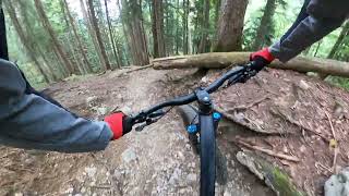
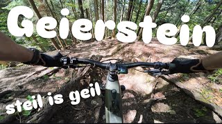
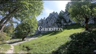
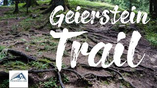
Starts near the peak of Geierstein. Rooty and rocky trail with some technical and steep sections. Some natural small jumps and drops. Several small twisty sections.

Access Info

Forest Road from an official parking lot at the south end of Lenggriess near "Ruine Hohenburg"

This trail is unsanctioned.

Recent Activity on Trail

Past Week
  • 0 rides
  •  
6 Months
  • 2 rides
  • 13 miles avg distance
All
  • 32 rides
  • Last: May 28, 2026
c1c2c3c4
January
February
March
April
May
June
July
August
September
October
November
December
Status:
on May 28, 2026
Dry
Avg: 4.33 (15 votes)
Your vote: 0

view (179)
close
3D
Trail Conditions
  • Unknown
  • Snow Groomed
  • Snow Packed
  • Snow Covered
  • Snow Cover Partial
  • Freeze/thaw Cycle
  • Icy
  • Prevalent Mud
  • Wet
  • Variable
  • Ideal
  • Dry
  • Very Dry
Trail Flow (Ridden Direction)
Trailforks scans users ridelogs to determine the most popular direction each trail is ridden. A good flowing trail network will have most trails flowing in a single direction according to their intension.
The colour categories are based on what percentage of riders are riding a trail in its intended direction.
  • > 96%
  • > 90%
  • > 80%
  • > 70%
  • > 50%
  • < 50%
  • bi-directional trail
  • no data
Trail Last Ridden
Trailforks scans ridelogs to determine the last time a trail was ridden.
  • < 2 days
  • < 1 week
  • < 2 weeks
  • < 1 month
  • < 6 months
  • > 6 months
Trail Ridden Direction
The intended direction a trail should be ridden.
  • Downhill Only
  • Downhill Primary
  • Both Directions
  • Uphill Primary
  • Uphill Only
  • One Direction
Contribute Details
Colors indicate trail is missing specified detail.
  • Description
  • Photos
  • Description & Photos
  • Videos
Trail Popularity ?
Trailforks scans ridelogs to determine which trails are ridden the most in the last 9 months. Trails are compared with nearby trails in the same city region with a possible 25 colour shades. Think of this as a heatmap, more rides = more kinetic energy = warmer colors.
  • most popular
  • popular
  • less popular
  • not popular
ATV/ORV/OHV Filter
Max Vehicle Width
inches
US Cell Coverage
Legend
cell carrier legend

Radar Time
Activity Recordings
Trailforks uses anonymized public activity data. ?
Activity Recordings
Trailforks uses anonymized public activity data. ?
Personal Heatmap
Activity Types
all / none
Options
2
Date range month
Winter Trails
Warning A routing network for winter maps does not exist. Selecting trails using the winter trails layer has been disabled.
Missing Trails
Most Popular
Least Popular
Trails are colored based on popularity. The more popular a trail is, the more red. Less popular trails trend towards green.
Jump Magnitude Heatmap
Heatmap of where riders jump on trails. Zoom in to see individual jumps, click circles to view jump details.
BC Backroad Status

Service Road Atlas is a free to use, community-driven service for viewing and creating reports on the numerous back-country service roads around B.C. and Alberta.

map legend
Slope Aspect
Direction the slope faces
Flat N NE E SE S SW W NW
Trails Deemphasized
Trails are shown in grey.
disable
Only show trails with no bike usage.
Enable
Suggested Layers
Based on selected activity type

    Save the current map location and zoom level as your default home location whenever this page is loaded.

    Save
        Directions to geierstein trailhead (47.682420, 11.624170)

        Photos

        26 more »
        107 |
        Oct 24, 2024 @ 6:56am
        Oct 24, 2024
        339 |
        Dec 2, 2020 @ 1:36am
        Dec 2, 2020
        294 |
        Dec 2, 2020 @ 1:32am
        Dec 2, 2020
        307 |
        Aug 14, 2020 @ 1:16pm
        Aug 14, 2020

        Videos

        4 more »
        Short Compilation
        0:01 | 63 | Sep 10, 2025 , Bad Tölz
        Geierstein Trail Lenggries - steil is geil (S3/S4)
        18:42 | 79 | Sep 2, 2025 , Bad Tölz
        Geierstein MTB (Lenggries) #6
        6:04 | 647 | Apr 13, 2022 , Bad Tölz
        MTB Trail am Geierstein bei Lenggries
        8:41 | 843 | Nov 29, 2019 , Bad Tölz

        10 Reviews & Comments


        We hope you've been enjoying Trailforks!

        Create a FREE account to view trail comments and much more.

        • #198544 - 3,589 views

        Frequently Asked Questions About Geierstein

        Where is Geierstein located?
        Geierstein is located in Bad Tölz/ Lenggries/ Sylvenstein Area, Bad Tölz, Germany. It is part of the Bad Tölz/ Lenggries/ Sylvenstein Area trail network. The trailhead is located at coordinates 47.68242, 11.62417.
        How hard is Geierstein?
        Geierstein is rated as Black difficulty. The average grade is 21.5%.
        What is the elevation gain for Geierstein?
        Geierstein has 7 ft of elevation gain. The trail has 1,902 ft of elevation descent. The elevation ranges from 2,522 ft to 4,418 ft.
        Is Geierstein a point to point trail?
        Yes, Geierstein is a point to point trail. The direction is Downhill Only. The trail type is singletrack.

        Hit the Trail

        Open in App

        Get this trail on your phone instantly.
        open trail in app

        Download Trail

        Save to wishlist, Garmin & download.
        save the trail

        Find Related Routes

        Find routes and users activities that include this trail.
        find routes for this trail

        You must enter a description before submitting.