more stats
3,291 ft
Distance
22 ft
Climb
-292 ft
Descent
00:14:09
Avg time
-270 ft
Altitude change
3,276 ft
Altitude min
3,559 ft
Altitude max
3,546 ft
Altitude start
3,276 ft
Altitude end
-8.199%
Grade
-40.765%
Grade max
29.084%
Grade min
376 ft
Distance climb
2,842 ft
Distance down
72 ft
Distance flat
00:14:09
Avg time

Gem Details

  • Activities
    • Mountain Bike
    • Horse
    • Hike
    • Trail Running
  • Riding Area
  • Difficulty Rating
  • Voted Difficulty
    Black Diamond (1 vote)
  • Local Popularity
    95 in Mountain Biking [+]
    • 85 in Trail Running
    • 65 in Hiking
    • 5 in Horseback
  • Global Ranking
    #11953 in Mountain Biking [+]
    • #27177 in Trail Running
    • #75342 in Hiking
  • Trail Type
    Singletrack
  • Bike Type
    AM, XC
  • Direction
    Both Directions
    Popular Direction Shown
  • Climb Difficulty
    Double Black Diamond
  • Physical Rating
    Extreme
  • eBike Allowed
  • TTFs on Trail
    Berm, Drop, Rock Face

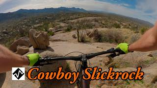
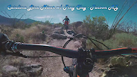
This short trail is full of freeride goodness if you look past the beaten path. There are a couple small drops and a couple optional rock face descents. Horses and cattle some times use this trail so beware of blind corners and loose rocks. This trail is by no means a double black however you can find some big faces to roll.

Local Trail Association

Recent Activity on Trail

Past Week
  • 0 rides
  •  
6 Months
  • 91 rides
  • 13 miles avg distance
All
  • 483 rides
  • Last: Jun 18, 2026
c1c2c3c4
January
February
March
April
May
June
July
August
September
October
November
December
Status:
on May 13, 2026
Dry
Avg: 4.36 (16 votes)
Your vote: 0

view (3,889)
close
3D
Trail Conditions
  • Unknown
  • Snow Groomed
  • Snow Packed
  • Snow Covered
  • Snow Cover Partial
  • Freeze/thaw Cycle
  • Icy
  • Prevalent Mud
  • Wet
  • Variable
  • Ideal
  • Dry
  • Very Dry
Trail Flow (Ridden Direction)
Trailforks scans users ridelogs to determine the most popular direction each trail is ridden. A good flowing trail network will have most trails flowing in a single direction according to their intension.
The colour categories are based on what percentage of riders are riding a trail in its intended direction.
  • > 96%
  • > 90%
  • > 80%
  • > 70%
  • > 50%
  • < 50%
  • bi-directional trail
  • no data
Trail Last Ridden
Trailforks scans ridelogs to determine the last time a trail was ridden.
  • < 2 days
  • < 1 week
  • < 2 weeks
  • < 1 month
  • < 6 months
  • > 6 months
Trail Ridden Direction
The intended direction a trail should be ridden.
  • Downhill Only
  • Downhill Primary
  • Both Directions
  • Uphill Primary
  • Uphill Only
  • One Direction
Contribute Details
Colors indicate trail is missing specified detail.
  • Description
  • Photos
  • Description & Photos
  • Videos
Trail Popularity ?
Trailforks scans ridelogs to determine which trails are ridden the most in the last 9 months. Trails are compared with nearby trails in the same city region with a possible 25 colour shades. Think of this as a heatmap, more rides = more kinetic energy = warmer colors.
  • most popular
  • popular
  • less popular
  • not popular
ATV/ORV/OHV Filter
Max Vehicle Width
inches
US Cell Coverage
Legend
cell carrier legend

Radar Time
Activity Recordings
Trailforks uses anonymized public activity data. ?
Activity Recordings
Trailforks uses anonymized public activity data. ?
Personal Heatmap
Activity Types
all / none
Options
2
Date range month
Winter Trails
Warning A routing network for winter maps does not exist. Selecting trails using the winter trails layer has been disabled.
Missing Trails
Most Popular
Least Popular
Trails are colored based on popularity. The more popular a trail is, the more red. Less popular trails trend towards green.
Jump Magnitude Heatmap
Heatmap of where riders jump on trails. Zoom in to see individual jumps, click circles to view jump details.
BC Backroad Status

Service Road Atlas is a free to use, community-driven service for viewing and creating reports on the numerous back-country service roads around B.C. and Alberta.

map legend
Slope Aspect
Direction the slope faces
Flat N NE E SE S SW W NW
Trails Deemphasized
Trails are shown in grey.
disable
Only show trails with no bike usage.
Enable
Suggested Layers
Based on selected activity type

    Save the current map location and zoom level as your default home location whenever this page is loaded.

    Save
        Directions to gem trailhead (32.501220, -110.859640)

        Photos

        9 more »
        38 |
        Jan 28, 2026 @ 8:21pm
        Jan 28, 2026
        27 |
        Jan 28, 2026 @ 8:20pm
        Jan 28, 2026
        30 |
        Jan 28, 2026 @ 8:19pm
        Jan 28, 2026
        32 |
        Jan 28, 2026 @ 8:19pm
        Jan 28, 2026

        Videos

        4 more »
        youtuber Cowboy Slickrock and Gem
        18:53 | 79 | Mar 6, 2026 , My City
        Gem Slabs and Middle Gate: Best of the 50-Year...
        11:01 | 206 | Mar 7, 2023 , My City
        Catalina State Park Tucson - MTB riding,...
        22:52 | 181 | Mar 7, 2021 , My City
        Catalina Line Mixer, w/ Trey Clay - Tucson AZ
        4:43 | 294 | Feb 4, 2018 , My City

        Routes with this trail

        5.0 14 miles 1,668 ft 8
        Similar to the V1 route, but takes Gem Slabs instead of Chutes. The bottom portion of Gem is similar to...
        11 miles 1,078 ft 7 Loop
        Nice combination of the Chutes and Gem DH. Return via Middle Gate.

        6 Reviews & Comments


        We hope you've been enjoying Trailforks!

        Create a FREE account to view trail comments and much more.

        • By toddTF Pro Trailforks & contributors
        • #15431 - 4,143 views

        Frequently Asked Questions About Gem

        Where is Gem located?
        Gem is located in Coronado National Forest - Mt Lemmon, Arizona, United States. It is part of the Coronado National Forest - Mt Lemmon trail network. The trailhead is located at coordinates 32.50122, -110.85964.
        How hard is Gem?
        Gem is rated as Black Diamond difficulty. The physical rating is Extreme. The average grade is 8.199%. The climb difficulty is rated Double Black Diamond.
        What is the elevation gain for Gem?
        Gem has 22 ft of elevation gain. The trail has 292 ft of elevation descent. The elevation ranges from 3,276 ft to 3,559 ft.
        Is Gem a point to point trail?
        Gem is not a point to point trail. The direction is Both Directions. The trail type is singletrack.

        Hit the Trail

        Open in App

        Get this trail on your phone instantly.
        open trail in app

        Download Trail

        Save to wishlist, Garmin & download.
        save the trail

        Find Related Routes

        Find routes and users activities that include this trail.
        find routes for this trail

        You must enter a description before submitting.