more stats
3.1 miles
Distance
15 ft
Climb
-568 ft
Descent
00:21:22
Avg time
-552 ft
Altitude change
5,458 ft
Altitude min
6,020 ft
Altitude max
6,020 ft
Altitude start
5,466 ft
Altitude end
-3.4%
Grade
-15.6%
Grade max
5.7%
Grade min
722 ft
Distance climb
3 miles
Distance down
774 ft
Distance flat
00:21:22
Avg time

Getaway (Top) Details

  • Activities
    • Mountain Bike
    • E-Bike
    • Adaptive Bike
    • Hike
    • Trail Running
  • Riding Area
    Mag 7
    Moab, Utah
  • Difficulty Rating
  • Voted Difficulty
    Blue (1 vote)
  • Local Popularity
    90 in Mountain Biking [+]
    • 55 in Trail Running
    • 65 in Hiking
  • Global Ranking
    #27303 in Mountain Biking [+]
    • #105323 in Trail Running
    • #72100 in Hiking
  • Trail Type
    Singletrack
  • Bike Type
    AM, XC, Adaptive MTB
  • Dogs Allowed
    Yes
  • eBike Allowed
    Yes up to Class 1
  • Land Owner
    BLM

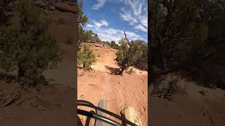
New trail to connect the parking area on 313 to the start of Bull Run. Sweet singletrack trail, way better than riding Gemini Bridges road

Adaptive Bike Info
aMTB Blue Rating: Intermediate features and steeper terrain.

Trail is generally 40 inches wide. Mostly on camber. Some spots off camber. They are certainly sections with rocks, drops, etc. Recommended west to east, due to some technical moves at several locations . Advanced riders will most likely be ok solo after some practice.

Trail Supporters
Local Trail Association
Traditionally Indigenous Territory

Recent Activity on Trail

Past Week
  • 0 rides
  •  
6 Months
  • 78 rides
  • 17 miles avg distance
All
  • 748 rides
  • Last: Mar 21, 2026
c1c2c3c4
January
February
March
April
May
June
July
August
September
October
November
December
Status:
on May 20, 2026
Ideal
Avg: 4.48 (42 votes)
Your vote: 0

view (4,682)
close
3D
Trail Conditions
  • Unknown
  • Snow Groomed
  • Snow Packed
  • Snow Covered
  • Snow Cover Partial
  • Freeze/thaw Cycle
  • Icy
  • Prevalent Mud
  • Wet
  • Variable
  • Ideal
  • Dry
  • Very Dry
Trail Flow (Ridden Direction)
Trailforks scans users ridelogs to determine the most popular direction each trail is ridden. A good flowing trail network will have most trails flowing in a single direction according to their intension.
The colour categories are based on what percentage of riders are riding a trail in its intended direction.
  • > 96%
  • > 90%
  • > 80%
  • > 70%
  • > 50%
  • < 50%
  • bi-directional trail
  • no data
Trail Last Ridden
Trailforks scans ridelogs to determine the last time a trail was ridden.
  • < 2 days
  • < 1 week
  • < 2 weeks
  • < 1 month
  • < 6 months
  • > 6 months
Trail Ridden Direction
The intended direction a trail should be ridden.
  • Downhill Only
  • Downhill Primary
  • Both Directions
  • Uphill Primary
  • Uphill Only
  • One Direction
Contribute Details
Colors indicate trail is missing specified detail.
  • Description
  • Photos
  • Description & Photos
  • Videos
Trail Popularity ?
Trailforks scans ridelogs to determine which trails are ridden the most in the last 9 months. Trails are compared with nearby trails in the same city region with a possible 25 colour shades. Think of this as a heatmap, more rides = more kinetic energy = warmer colors.
  • most popular
  • popular
  • less popular
  • not popular
ATV/ORV/OHV Filter
Max Vehicle Width
inches
US Cell Coverage
Legend
cell carrier legend

Radar Time
Activity Recordings
Trailforks uses anonymized public activity data. ?
Activity Recordings
Trailforks uses anonymized public activity data. ?
Personal Heatmap
Activity Types
all / none
Options
2
Date range month
Winter Trails
Warning A routing network for winter maps does not exist. Selecting trails using the winter trails layer has been disabled.
Missing Trails
Most Popular
Least Popular
Trails are colored based on popularity. The more popular a trail is, the more red. Less popular trails trend towards green.
Jump Magnitude Heatmap
Heatmap of where riders jump on trails. Zoom in to see individual jumps, click circles to view jump details.
BC Backroad Status

Service Road Atlas is a free to use, community-driven service for viewing and creating reports on the numerous back-country service roads around B.C. and Alberta.

map legend
Slope Aspect
Direction the slope faces
Flat N NE E SE S SW W NW
Trails Deemphasized
Trails are shown in grey.
disable
Only show trails with no bike usage.
Enable
Suggested Layers
Based on selected activity type

    Save the current map location and zoom level as your default home location whenever this page is loaded.

    Save
        Directions to getaway-top trailhead (38.573460, -109.791710)

        Photos

        14 more »
        15 |
        Apr 9, 2026 @ 8:49pm
        Apr 9, 2026
        48 |
        Aug 18, 2025 @ 2:44pm
        Aug 18, 2025
        58 |
        Aug 18, 2025 @ 2:44pm
        Aug 18, 2025
        49 |
        Aug 18, 2025 @ 2:44pm
        Aug 18, 2025

        Videos

        10 more »
        youtuber Mountain Biking Mag 7 in Moab, UT | Giant...
        8:15 | 757 | May 17, 2018 , Moab
        youtuber Getaway & Great Escape 2018 Moab, Utah...
        10:35 | 863 | Apr 30, 2018 , Moab
        youtuber Mag 7 - Getaway (top) | Moab, Utah
        13:25 | 833 | Jun 6, 2018 , Moab
        Getatway highlights of top section
        70 | Aug 18, 2025 , Moab

        Trail Lists

        Routes with this trail

        4.4 21 miles 1,779 ft 19 Shuttled
        This is the Mag 7 ride, named after the 7 trails it includes. There are alternate routes but this one is...
        4.4 16 miles 647 ft 11 Shuttled
        The Mag 5 ride is an awesome shuttle. The terrain is fairly intermediate and not super steep either....
        5.0 17 miles 656 ft 13
        The Mag 5 ride is an awesome shuttle. The terrain is fairly intermediate and not super steep either....

        5 Reviews & Comments


        We hope you've been enjoying Trailforks!

        Create a FREE account to view trail comments and much more.

        • By canadakaTF Pro Trailforks & contributors
        • #36714 - 6,457 views

        Frequently Asked Questions About Getaway (Top)

        Where is Getaway (Top) located?
        Getaway (Top) is located in Mag 7, Moab, Utah, United States. It is part of the Mag 7 trail network. The trailhead is located at coordinates 38.57346, -109.79171.
        How hard is Getaway (Top)?
        Getaway (Top) is rated as Blue difficulty. The average grade is 3.4%.
        What is the elevation gain for Getaway (Top)?
        Getaway (Top) has 15 ft of elevation gain. The trail has 568 ft of elevation descent. The elevation ranges from 5,458 ft to 6,020 ft.
        How long is Getaway (Top)?
        Getaway (Top) is 3.1 miles long. The trail type is singletrack.

        Hit the Trail

        Open in App

        Get this trail on your phone instantly.
        open trail in app

        Download Trail

        Save to wishlist, Garmin & download.
        save the trail

        Find Related Routes

        Find routes and users activities that include this trail.
        find routes for this trail

        You must enter a description before submitting.