more stats
1,155 ft
Distance
-111 ft
Descent
00:02:26
Avg time
-111 ft
Altitude change
300 ft
Altitude min
411 ft
Altitude max
410 ft
Altitude start
299 ft
Altitude end
-9.6%
Grade
-23.3%
Grade max
1.5%
Grade min
69 ft
Distance climb
1,086 ft
Distance down
00:02:26
Avg time

Getryggen Backside Details

  • Activities
    • Mountain Bike
    • Hike
    • Trail Running
  • Riding Area
    Delsjöområdet
    Göteborg
  • Difficulty Rating
  • Voted Difficulty
    Red (1 vote)
  • Local Popularity
    85 in Mountain Biking [+]
    • 100 in Trail Running
    • 70 in Hiking
  • Global Ranking
    #125140 in Mountain Biking [+]
    • #1651 in Trail Running
    • #37900 in Hiking
  • Trail Type
    Singletrack
  • Bike Type
    AM, XC
  • Direction
    Downhill Primary
  • Dogs Allowed
    Yes
  • eBike Allowed

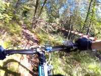
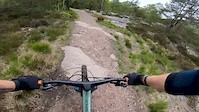
Utförsåk ner från Getryggen som bjuder på en mix av klipphäll, skråsväng, rötter och några mindre kanter och små trappsteg/stendrop.

Del av Vildmarksleden. Fram till 2020 även utmärkt del av Bohusleden men denna är nu flyttad till PåSkrå DeHå.

Local Trail Association

Recent Activity on Trail

Past Week
  • 2 rides
  • 9 miles average
6 Months
  • 14 rides
  • 18 miles avg distance
All
  • 199 rides
  • Last: Jun 15, 2026
c1c2c3c4
January
February
March
April
May
June
July
August
September
October
November
December
Status:
on May 29, 2026
Dry
no votes yet
Your vote: 0

view (1,917)
close
3D
Trail Conditions
  • Unknown
  • Snow Groomed
  • Snow Packed
  • Snow Covered
  • Snow Cover Partial
  • Freeze/thaw Cycle
  • Icy
  • Prevalent Mud
  • Wet
  • Variable
  • Ideal
  • Dry
  • Very Dry
Trail Flow (Ridden Direction)
Trailforks scans users ridelogs to determine the most popular direction each trail is ridden. A good flowing trail network will have most trails flowing in a single direction according to their intension.
The colour categories are based on what percentage of riders are riding a trail in its intended direction.
  • > 96%
  • > 90%
  • > 80%
  • > 70%
  • > 50%
  • < 50%
  • bi-directional trail
  • no data
Trail Last Ridden
Trailforks scans ridelogs to determine the last time a trail was ridden.
  • < 2 days
  • < 1 week
  • < 2 weeks
  • < 1 month
  • < 6 months
  • > 6 months
Trail Ridden Direction
The intended direction a trail should be ridden.
  • Downhill Only
  • Downhill Primary
  • Both Directions
  • Uphill Primary
  • Uphill Only
  • One Direction
Contribute Details
Colors indicate trail is missing specified detail.
  • Description
  • Photos
  • Description & Photos
  • Videos
Trail Popularity ?
Trailforks scans ridelogs to determine which trails are ridden the most in the last 9 months. Trails are compared with nearby trails in the same city region with a possible 25 colour shades. Think of this as a heatmap, more rides = more kinetic energy = warmer colors.
  • most popular
  • popular
  • less popular
  • not popular
ATV/ORV/OHV Filter
Max Vehicle Width
inches
US Cell Coverage
Legend
cell carrier legend

Radar Time
Activity Recordings
Trailforks uses anonymized public activity data. ?
Activity Recordings
Trailforks uses anonymized public activity data. ?
Personal Heatmap
Activity Types
all / none
Options
2
Date range month
Winter Trails
Warning A routing network for winter maps does not exist. Selecting trails using the winter trails layer has been disabled.
Missing Trails
Most Popular
Least Popular
Trails are colored based on popularity. The more popular a trail is, the more red. Less popular trails trend towards green.
Jump Magnitude Heatmap
Heatmap of where riders jump on trails. Zoom in to see individual jumps, click circles to view jump details.
BC Backroad Status

Service Road Atlas is a free to use, community-driven service for viewing and creating reports on the numerous back-country service roads around B.C. and Alberta.

map legend
Slope Aspect
Direction the slope faces
Flat N NE E SE S SW W NW
Trails Deemphasized
Trails are shown in grey.
disable
Only show trails with no bike usage.
Enable
Suggested Layers
Based on selected activity type

    Save the current map location and zoom level as your default home location whenever this page is loaded.

    Save
        Directions to getryggen-backside trailhead (57.705030, 12.068900)

        Photos

        No photos have been added for Getryggen Backside yet, add a photo.

        Videos

        2 more »
        Hillside DH 2015 - Pre-Run 2015-08-21
        3:08 | 259 | Feb 20, 2020 , Göteborg
        Getryggen
        0:24 | 125 | Jun 4, 2020 , Göteborg

        Routes with this trail

        16 miles 1,853 ft 18
        Fett ball, svåraste leden i hela världen. Stor eloge till de som klarar allt

        Reviews / Comments

        No reviews yet, be the first to write a review or ask a question.
        Use trail reports to comment on trail conditions.


        We hope you've been enjoying Trailforks!

        Create a FREE account to view trail comments and much more.

        • By PatternsOnTF Pro & contributors
        • #42631 - 1,717 views

        Frequently Asked Questions About Getryggen Backside

        Where is Getryggen Backside located?
        Getryggen Backside is located in Delsjöområdet, Göteborg, Sweden. It is part of the Delsjöområdet trail network. The trailhead is located at coordinates 57.70503, 12.0689.
        How hard is Getryggen Backside?
        Getryggen Backside is rated as Blue difficulty. The average grade is 9.6%.
        What is the elevation gain for Getryggen Backside?
        The trail has 111 ft of elevation descent. The elevation ranges from 300 ft to 411 ft.
        Is Getryggen Backside a point to point trail?
        Getryggen Backside is not a point to point trail. The direction is Downhill Primary. The trail type is singletrack.

        Hit the Trail

        Open in App

        Get this trail on your phone instantly.
        open trail in app

        Download Trail

        Save to wishlist, Garmin & download.
        save the trail

        Find Related Routes

        Find routes and users activities that include this trail.
        find routes for this trail

        You must enter a description before submitting.