This trail is permanently closed/decommissioned
more stats
3,478 ft
Distance
3 ft
Climb
-652 ft
Descent
00:04:04
Avg time
-649 ft
Altitude change
665 ft
Altitude min
1,317 ft
Altitude max
1,314 ft
Altitude start
666 ft
Altitude end
-18.7%
Grade
-40.7%
Grade max
5%
Grade min
39 ft
Distance climb
3,294 ft
Distance down
144 ft
Distance flat
00:04:04
Avg time

Ghetto Track Details

  • Activities
    • Mountain Bike
  • Riding Area
  • Difficulty Rating
  • Local Popularity
    65 in Mountain Biking
  • Trail Type
    Singletrack
  • Bike Type
    DH, AM
  • Direction
    Downhill Only
  • Dogs Allowed
    Yes
  • Ride in Rain
    Yes

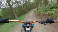
The most natural of the Revolution Bike Park trails weaving its way through the woodland with loam for days.

Access Info

Follow Red Downhill until the first fire road where there is a split.

Bike Park

Recent Activity on Trail

Past Week
  • 0 rides
  •  
6 Months
  • 9 rides
  • 14 miles avg distance
All
  • 38 rides
  • Last: Jun 14, 2026
c1c2c3c4
January
February
March
April
May
June
July
August
September
October
November
December
update trails status or condition

Ghetto Track Trail Reports

statusdatedescription
Dec 2, 2022 @ 6:26pm
Dec 2, 2022
more »
Status:
on Dec 2, 2022
Prevalent Mud
Avg: 4.35 (5 votes)
Your vote: 0

view (923)
close
3D
Trail Conditions
  • Unknown
  • Snow Groomed
  • Snow Packed
  • Snow Covered
  • Snow Cover Partial
  • Freeze/thaw Cycle
  • Icy
  • Prevalent Mud
  • Wet
  • Variable
  • Ideal
  • Dry
  • Very Dry
Trail Flow (Ridden Direction)
Trailforks scans users ridelogs to determine the most popular direction each trail is ridden. A good flowing trail network will have most trails flowing in a single direction according to their intension.
The colour categories are based on what percentage of riders are riding a trail in its intended direction.
  • > 96%
  • > 90%
  • > 80%
  • > 70%
  • > 50%
  • < 50%
  • bi-directional trail
  • no data
Trail Last Ridden
Trailforks scans ridelogs to determine the last time a trail was ridden.
  • < 2 days
  • < 1 week
  • < 2 weeks
  • < 1 month
  • < 6 months
  • > 6 months
Trail Ridden Direction
The intended direction a trail should be ridden.
  • Downhill Only
  • Downhill Primary
  • Both Directions
  • Uphill Primary
  • Uphill Only
  • One Direction
Contribute Details
Colors indicate trail is missing specified detail.
  • Description
  • Photos
  • Description & Photos
  • Videos
Trail Popularity ?
Trailforks scans ridelogs to determine which trails are ridden the most in the last 9 months. Trails are compared with nearby trails in the same city region with a possible 25 colour shades. Think of this as a heatmap, more rides = more kinetic energy = warmer colors.
  • most popular
  • popular
  • less popular
  • not popular
ATV/ORV/OHV Filter
Max Vehicle Width
inches
US Cell Coverage
Legend
cell carrier legend

Radar Time
Activity Recordings
Trailforks uses anonymized public activity data. ?
Activity Recordings
Trailforks uses anonymized public activity data. ?
Personal Heatmap
Activity Types
all / none
Options
2
Date range month
Winter Trails
Warning A routing network for winter maps does not exist. Selecting trails using the winter trails layer has been disabled.
Missing Trails
Most Popular
Least Popular
Trails are colored based on popularity. The more popular a trail is, the more red. Less popular trails trend towards green.
Jump Magnitude Heatmap
Heatmap of where riders jump on trails. Zoom in to see individual jumps, click circles to view jump details.
BC Backroad Status

Service Road Atlas is a free to use, community-driven service for viewing and creating reports on the numerous back-country service roads around B.C. and Alberta.

map legend
Slope Aspect
Direction the slope faces
Flat N NE E SE S SW W NW
Trails Deemphasized
Trails are shown in grey.
disable
Only show trails with no bike usage.
Enable
Suggested Layers
Based on selected activity type

    Save the current map location and zoom level as your default home location whenever this page is loaded.

    Save
        Directions to ghetto-track trailhead (52.811650, -3.408420)

        Photos

        36 more »
        152 |
        May 1, 2019 @ 1:26pm
        May 1, 2019
        220 |
        Nov 11, 2016 @ 12:45am
        Nov 11, 2016
        103 |
        May 1, 2019 @ 1:23pm
        May 1, 2019
        106 |
        Feb 27, 2018 @ 3:49am
        Feb 27, 2018

        Videos

        19 more »
        youtuber Riding in Wales and England, Bikepark Wales,...
        16:21 | 411 | Nov 18, 2018 , Llangynog
        Freeride, Ghetto Track, Reddy McRedface |...
        5:02 | 343 | Jul 21, 2018 , Llangynog
        Tree hugging
        0:38 | 316 | Aug 1, 2019 , Llangynog
        Revolution Bike Park - Crash
        0:15 | 544 | Apr 7, 2018 , Llangynog

        1 Review & Comments


        We hope you've been enjoying Trailforks!

        Create a FREE account to view trail comments and much more.

        • By wiseyTF Pro TRAILFORKS & contributors
        • #31713 - 2,376 views

        Frequently Asked Questions About Ghetto Track

        Where is Ghetto Track located?
        Ghetto Track is located in Revolution Bikepark, Llangynog, United Kingdom. It is part of the Revolution Bikepark trail network. The trailhead is located at coordinates 52.81165, -3.40842.
        How hard is Ghetto Track?
        Ghetto Track is rated as Black difficulty. The average grade is 18.7%.
        What is the elevation gain for Ghetto Track?
        Ghetto Track has 3 ft of elevation gain. The trail has 652 ft of elevation descent. The elevation ranges from 665 ft to 1,317 ft.
        Is Ghetto Track a point to point trail?
        Yes, Ghetto Track is a point to point trail. The direction is Downhill Only. The trail type is singletrack.

        Hit the Trail

        Open in App

        Get this trail on your phone instantly.
        open trail in app

        Download Trail

        Save to wishlist, Garmin & download.
        save the trail

        Find Related Routes

        Find routes and users activities that include this trail.
        find routes for this trail

        You must enter a description before submitting.