more stats
1,969 ft
Distance
-286 ft
Descent
00:03:11
Avg time
-286 ft
Altitude change
1,186 ft
Altitude min
1,471 ft
Altitude max
1,471 ft
Altitude start
1,184 ft
Altitude end
-14.5%
Grade
-38.6%
Grade max
-7%
Grade min
1,969 ft
Distance down
00:03:11
Avg time

Giant Killer Details

  • Activities
    • Mountain Bike
    • Hike
    • Trail Running
  • Riding Area
    Woodlot
    Maple Ridge, British Columbia
  • AKA
    GK, Giant
  • Difficulty Rating
  • Voted Difficulty
    Blue (5 votes)
  • Local Popularity
    85 in Mountain Biking [+]
    • 35 in Trail Running
    • 35 in Hiking
  • Global Ranking
    #14275 in Mountain Biking [+]
    • #111199 in Trail Running
    • #114763 in Hiking
  • Trail Type
    Singletrack
  • Bike Type
    DH, AM
  • Climb Difficulty
    Double Black Diamond
  • Physical Rating
    Moderate
  • Trail Visibility
    Always easy to follow
  • Dogs Allowed
    Yes
  • eBike Allowed
  • TTFs on Trail
    A-Frame, Berm, Bridge, Drop, Jump, Gap Jump, Ladder Bridge

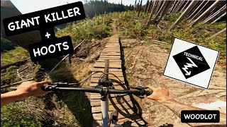
This is one of the Maple Ridge Woodlot classics, newly re-imagined for sustainability by builder's Ryan and Eugene.


With plenty of challenges, this ride hooks up with great fall line riding from Blood Donor, and flows nicely into Hoots.

Trail Supporters
Local Trail Association

Recent Activity on Trail

Past Week
  • 5 rides
  • 12.3 km average
6 Months
  • 167 rides
  • 10.9 km avg distance
All
  • 1,280 rides
  • Last: Jun 14, 2026
c1c2c3c4
January
February
March
April
May
June
July
August
September
October
November
December
Status:
on May 17, 2026
Ideal
Avg: 4.53 (58 votes)
Your vote: 0

view (5,427)
close
3D
Trail Conditions
  • Unknown
  • Snow Groomed
  • Snow Packed
  • Snow Covered
  • Snow Cover Partial
  • Freeze/thaw Cycle
  • Icy
  • Prevalent Mud
  • Wet
  • Variable
  • Ideal
  • Dry
  • Very Dry
Trail Flow (Ridden Direction)
Trailforks scans users ridelogs to determine the most popular direction each trail is ridden. A good flowing trail network will have most trails flowing in a single direction according to their intension.
The colour categories are based on what percentage of riders are riding a trail in its intended direction.
  • > 96%
  • > 90%
  • > 80%
  • > 70%
  • > 50%
  • < 50%
  • bi-directional trail
  • no data
Trail Last Ridden
Trailforks scans ridelogs to determine the last time a trail was ridden.
  • < 2 days
  • < 1 week
  • < 2 weeks
  • < 1 month
  • < 6 months
  • > 6 months
Trail Ridden Direction
The intended direction a trail should be ridden.
  • Downhill Only
  • Downhill Primary
  • Both Directions
  • Uphill Primary
  • Uphill Only
  • One Direction
Contribute Details
Colors indicate trail is missing specified detail.
  • Description
  • Photos
  • Description & Photos
  • Videos
Trail Popularity ?
Trailforks scans ridelogs to determine which trails are ridden the most in the last 9 months. Trails are compared with nearby trails in the same city region with a possible 25 colour shades. Think of this as a heatmap, more rides = more kinetic energy = warmer colors.
  • most popular
  • popular
  • less popular
  • not popular
ATV/ORV/OHV Filter
Max Vehicle Width
inches
US Cell Coverage
Legend
cell carrier legend

Radar Time
Activity Recordings
Trailforks uses anonymized public activity data. ?
Activity Recordings
Trailforks uses anonymized public activity data. ?
Personal Heatmap
Activity Types
all / none
Options
2
Date range month
Winter Trails
Warning A routing network for winter maps does not exist. Selecting trails using the winter trails layer has been disabled.
Missing Trails
Most Popular
Least Popular
Trails are colored based on popularity. The more popular a trail is, the more red. Less popular trails trend towards green.
Jump Magnitude Heatmap
Heatmap of where riders jump on trails. Zoom in to see individual jumps, click circles to view jump details.
BC Backroad Status

Service Road Atlas is a free to use, community-driven service for viewing and creating reports on the numerous back-country service roads around B.C. and Alberta.

map legend
Slope Aspect
Direction the slope faces
Flat N NE E SE S SW W NW
Trails Deemphasized
Trails are shown in grey.
disable
Only show trails with no bike usage.
Enable
Suggested Layers
Based on selected activity type

    Save the current map location and zoom level as your default home location whenever this page is loaded.

    Save
        Directions to giant-killer trailhead (49.237410, -122.432910)

        Photos

        203 more »
        716 |
        Feb 14, 2015 @ 4:00pm
        Feb 14, 2015
        276 |
        Nov 25, 2013 @ 11:13am
        Nov 25, 2013
        45 |
        Nov 24, 2025 @ 8:42pm
        Nov 24, 2025
        40 |
        Oct 10, 2024 @ 6:47pm
        Oct 10, 2024

        Videos

        29 more »
        youtuber GIANT KILLER + HOOTS | Single Black trail |...
        3:01 | 169 | Oct 24, 2024 , Maple Ridge
        youtuber AMAZING FREERIDE TRAILS!  All Good Things Come...
        11:45 | 1182 | Mar 6, 2019 , Maple Ridge
        Happy Lagwagon Day!  (a day late)
        0:49 | 40 | May 22, 2026 , Maple Ridge
        Giant Killer Mar 21 2024
        2:11 | 183 | Mar 23, 2024 , Maple Ridge

        Routes with this trail

        12 miles 3,146 ft 17
        Fraser Valley Woodlot Epic Fraser Valley Relive Your Ride For other ride suggestions for this and other...
        5 miles 1,438 ft 16
        A short lap of some of the best this zone has to offer in a Blue category.

        Trail Products

        10 Reviews & Comments


        We hope you've been enjoying Trailforks!

        Create a FREE account to view trail comments and much more.

        Nearby Trails

        • By BCpovTF Pro & contributors
        • #95 - 10,407 views

        Frequently Asked Questions About Giant Killer

        Where is Giant Killer located?
        Giant Killer is located in Woodlot, Maple Ridge, British Columbia, Canada. It is part of the Woodlot trail network. The trailhead is located at coordinates 49.23741, -122.43291.
        How hard is Giant Killer?
        Giant Killer is rated as Black Diamond difficulty. The physical rating is Moderate. The average grade is 14.5%. The climb difficulty is rated Double Black Diamond.
        What is the elevation gain for Giant Killer?
        The trail has 87 m of elevation descent. The elevation ranges from 361 m to 449 m.
        How long is Giant Killer?
        Giant Killer is 600.0 m long. The trail type is singletrack.

        Hit the Trail

        Open in App

        Get this trail on your phone instantly.
        open trail in app

        Download Trail

        Save to wishlist, Garmin & download.
        save the trail

        Find Related Routes

        Find routes and users activities that include this trail.
        find routes for this trail

        You must enter a description before submitting.