


Open in App
Get this trail on your phone instantly.

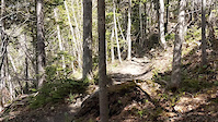
Ginger Route is a biking-primary multi-use trail designed for the beginner to advanced rider. The trail has several narrow sections and steep switchbacks near the end that can make a challenging climb for the beginner rider.
Access from the upper Margaret Bowater parking lot or from the top of Ginger Route at Crockers Road.
Trail can get very slippery when wet. To maintain trail quality, please avoid during heavy wet weather.
| c1 | c2 | c3 | c4 |
|---|---|---|---|
January | February | March | April |
May | June | July | August |
September | October | November | December |

Service Road Atlas is a free to use, community-driven service for viewing and creating reports on the numerous back-country service roads around B.C. and Alberta.
Save the current map location and zoom level as your default home location whenever this page is loaded.
Save
No reviews yet, be the first to write a review or ask a question.
Use trail reports to comment on trail conditions.
We hope you've been enjoying Trailforks!
Create a FREE account to view trail comments and much more.
You must enter a description before submitting.

