more stats
2.0 miles
Distance
93 ft
Climb
-519 ft
Descent
00:13:41
Avg time
-427 ft
Altitude change
2,110 ft
Altitude min
2,547 ft
Altitude max
2,537 ft
Altitude start
2,110 ft
Altitude end
-4.1%
Grade
-20.4%
Grade max
14.8%
Grade min
1,677 ft
Distance climb
1 mile
Distance down
2,028 ft
Distance flat
00:13:41
Avg time

Glacier view Details

  • Activities
    • Mountain Bike
    • Hike
    • Trail Running
  • Riding Area
    Sage Hills
    Wenatchee, Washington
  • Difficulty Rating
  • Local Popularity
    90 in Mountain Biking [+]
    • 70 in Trail Running
    • 75 in Hiking
  • Global Ranking
    #43771 in Mountain Biking [+]
    • #90769 in Trail Running
    • #72175 in Hiking
  • Trail Type
    Singletrack
  • Bike Type
    AM, XC
  • Climb Difficulty
    Blue
  • Physical Rating
    Moderate
  • Season
    April through November
  • Dogs Allowed
    Yes
  • eBike Allowed
  • Land Owner
    Chelan-Douglas Land trust

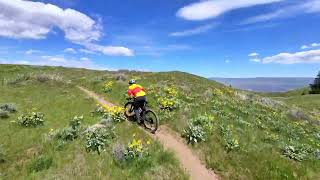
The Glacier View trail was flagged in the fall of 2015 and cut in spring of 2016 by Chelan Douglas Land Trust volunteers. The handbuilt top section meanders across level terrain below Horse Lake (which is sometimes a dry lakebed and sometimes has water) with spectacular views of the Wenatchee River Valley 2000 feet below. The trail starts to head downhill with flowing narrow singletrack that was machine built for the first mile of descending and then handbuilt through sagebrush forests for the bottom mile of descending. The trail turns back toward the Homestead trail service road at the bottom of the descent with a short climb and more level terrain to finish. Seasonal wildflowers including balsam root and lupine are incredible from mid-April through mid-May. Peak seasons for riding are April 1 - May 31 and then September 15 - November 30.

Local Trail Association
Traditionally Indigenous Territory

Recent Activity on Trail

Past Week
  • 1 rides
  • 17 miles average
6 Months
  • 84 rides
  • 20 miles avg distance
All
  • 692 rides
  • Last: Jun 20, 2026
c1c2c3c4
January
February
March
April
May
June
July
August
September
October
November
December
update trails status or condition

Glacier view Trail Reports

statusdatedescription
Apr 13, 2026 @ 5:58pm (America/Los_Angeles)
Apr 13, 2026
Apr 1, 2026 @ 12:03am (America/Los_Angeles)
Apr 1, 2026
Dec 1, 2025 @ 8:38am (America/Los_Angeles)
Dec 1, 2025
All trails in Sage Hills and the Horse Lake Reserve are under a seasonal closure from December 1st until April 1st to protect migrating mule deer...
Sep 4, 2025 @ 9:05pm
Sep 4, 2025
Grass is overgrown but still rideable
May 26, 2025 @ 4:21pm
May 26, 2025
Dry but good
more »
Status:
on Apr 13, 2026
Ideal
Avg: 4.08 (18 votes)
Your vote: 0

view (2,781)
close
3D
Trail Conditions
  • Unknown
  • Snow Groomed
  • Snow Packed
  • Snow Covered
  • Snow Cover Partial
  • Freeze/thaw Cycle
  • Icy
  • Prevalent Mud
  • Wet
  • Variable
  • Ideal
  • Dry
  • Very Dry
Trail Flow (Ridden Direction)
Trailforks scans users ridelogs to determine the most popular direction each trail is ridden. A good flowing trail network will have most trails flowing in a single direction according to their intension.
The colour categories are based on what percentage of riders are riding a trail in its intended direction.
  • > 96%
  • > 90%
  • > 80%
  • > 70%
  • > 50%
  • < 50%
  • bi-directional trail
  • no data
Trail Last Ridden
Trailforks scans ridelogs to determine the last time a trail was ridden.
  • < 2 days
  • < 1 week
  • < 2 weeks
  • < 1 month
  • < 6 months
  • > 6 months
Trail Ridden Direction
The intended direction a trail should be ridden.
  • Downhill Only
  • Downhill Primary
  • Both Directions
  • Uphill Primary
  • Uphill Only
  • One Direction
Contribute Details
Colors indicate trail is missing specified detail.
  • Description
  • Photos
  • Description & Photos
  • Videos
Trail Popularity ?
Trailforks scans ridelogs to determine which trails are ridden the most in the last 9 months. Trails are compared with nearby trails in the same city region with a possible 25 colour shades. Think of this as a heatmap, more rides = more kinetic energy = warmer colors.
  • most popular
  • popular
  • less popular
  • not popular
ATV/ORV/OHV Filter
Max Vehicle Width
inches
US Cell Coverage
Legend
cell carrier legend

Radar Time
Activity Recordings
Trailforks uses anonymized public activity data. ?
Activity Recordings
Trailforks uses anonymized public activity data. ?
Personal Heatmap
Activity Types
all / none
Options
2
Date range month
Winter Trails
Warning A routing network for winter maps does not exist. Selecting trails using the winter trails layer has been disabled.
Missing Trails
Most Popular
Least Popular
Trails are colored based on popularity. The more popular a trail is, the more red. Less popular trails trend towards green.
Jump Magnitude Heatmap
Heatmap of where riders jump on trails. Zoom in to see individual jumps, click circles to view jump details.
BC Backroad Status

Service Road Atlas is a free to use, community-driven service for viewing and creating reports on the numerous back-country service roads around B.C. and Alberta.

map legend
Slope Aspect
Direction the slope faces
Flat N NE E SE S SW W NW
Trails Deemphasized
Trails are shown in grey.
disable
Only show trails with no bike usage.
Enable
Suggested Layers
Based on selected activity type

    Save the current map location and zoom level as your default home location whenever this page is loaded.

    Save
        Directions to glacier-view trailhead (47.450110, -120.404120)

        Photos

        34 more »
        1,074 |
        Apr 29, 2019 @ 12:12pm
        Apr 29, 2019
        61 |
        May 26, 2025 @ 12:03pm
        May 26, 2025
        58 |
        Oct 27, 2024 @ 5:49pm
        Oct 27, 2024
        80 |
        Mar 17, 2024 @ 2:23pm
        Mar 17, 2024

        Videos

        2 more »
        Glacier View Trail Mountain Biking in...
        2:22 | 61 | May 11, 2026 , Wenatchee
        Glacier View and Homestead Loop
        5:09 | 604 | May 10, 2021 , Wenatchee

        Routes with this trail

        4.4 13 miles 2,303 ft 9
        Up Horselake trail down to through Sage across Balsamroot back
        14 miles 2,461 ft 9
        Up Horselake trail down to through Sage across back
        14 miles 2,489 ft 8
        Burts, Glacier View, Apricot Crisp, up over back on Balsom root

        2 Reviews & Comments


        We hope you've been enjoying Trailforks!

        Create a FREE account to view trail comments and much more.

        • By bradakTF Pro & contributors
        • #64897 - 5,459 views

        Frequently Asked Questions About Glacier view

        Where is Glacier view located?
        Glacier view is located in Sage Hills, Wenatchee, Washington, United States. It is part of the Sage Hills trail network. The trailhead is located at coordinates 47.45011, -120.40412.
        How hard is Glacier view?
        Glacier view is rated as Blue difficulty. The physical rating is Moderate. The average grade is 4.1%. The climb difficulty is rated Blue.
        What is the elevation gain for Glacier view?
        Glacier view has 93 ft of elevation gain. The trail has 519 ft of elevation descent. The elevation ranges from 2,110 ft to 2,547 ft.
        How long is Glacier view?
        Glacier view is 2.0 miles long. The trail type is singletrack.

        Hit the Trail

        Open in App

        Get this trail on your phone instantly.
        open trail in app

        Download Trail

        Save to wishlist, Garmin & download.
        save the trail

        Find Related Routes

        Find routes and users activities that include this trail.
        find routes for this trail

        You must enter a description before submitting.