more stats
1.4 miles
Distance
106 ft
Climb
-162 ft
Descent
00:11:04
Avg time
-57 ft
Altitude change
241 ft
Altitude min
337 ft
Altitude max
299 ft
Altitude start
243 ft
Altitude end
-0.8%
Grade
-15.1%
Grade max
12.4%
Grade min
3,291 ft
Distance climb
3,743 ft
Distance down
541 ft
Distance flat
00:11:04
Avg time

Glider Details

  • Activities
    • Mountain Bike
    • E-Bike
    • Horse
    • Hike
    • Trail Running
  • Riding Area
    Daisy Hill
    Brisbane
  • Ref Number
    #10
  • Difficulty Rating
  • Voted Difficulty
    Blue (4 votes)
  • Local Popularity
    95 in Mountain Biking [+]
    • 95 in E-Biking
    • 70 in Trail Running
    • 55 in Hiking
    • 5 in Horseback
  • Global Ranking
    #474 in Mountain Biking [+]
    • #2456 in E-Biking
    • #61921 in Trail Running
    • #107418 in Hiking
    • #1323 in Horseback
  • Trail Type
    Singletrack
  • Bike Type
    AM
  • Direction
    Both Directions
  • Climb Difficulty
    Blue
  • Physical Rating
    Moderate
  • Dogs Allowed
    Yes
  • eBike Allowed
    Yes up to Class 1
  • TTFs on Trail
    Berm, Bridge, Drop, Jump
  • Land Owner
    Logan City Council

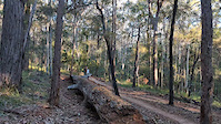
Glider can be ridden in both directions and has some great features - berms, switchbacks, tight rocky section and rollovers. Most of the trail is easy 'green' trail riding with nice flow and some sections get quite fast which is a good reward for the minor, steady climb sections. The trail serves as an important connector from other Daisy Hill trails to the Wiry Panic/Stonehenge area near Ford Rd. It also delivers riders to the Quarry - a popular spot for all recreational users given it's now a lake.

N.B. this trail is a green trail, but for some difficult terrain and tight turns around the quarry section

(the trail has four parts divided by fire trails and one at the quarry turn-off)

Local Trail Association
Traditionally Indigenous Territory

Recent Activity on Trail

Past Week
  • 7 rides
  • 15 miles average
6 Months
  • 243 rides
  • 16 miles avg distance
All
  • 3,702 rides
  • Last: Jun 19, 2026
c1c2c3c4
January
February
March
April
May
June
July
August
September
October
November
December
Status:
on Jun 7, 2026
Ideal
Avg: 3.93 (10 votes)
Your vote: 0

view (25,081)
close
3D
Trail Conditions
  • Unknown
  • Snow Groomed
  • Snow Packed
  • Snow Covered
  • Snow Cover Partial
  • Freeze/thaw Cycle
  • Icy
  • Prevalent Mud
  • Wet
  • Variable
  • Ideal
  • Dry
  • Very Dry
Trail Flow (Ridden Direction)
Trailforks scans users ridelogs to determine the most popular direction each trail is ridden. A good flowing trail network will have most trails flowing in a single direction according to their intension.
The colour categories are based on what percentage of riders are riding a trail in its intended direction.
  • > 96%
  • > 90%
  • > 80%
  • > 70%
  • > 50%
  • < 50%
  • bi-directional trail
  • no data
Trail Last Ridden
Trailforks scans ridelogs to determine the last time a trail was ridden.
  • < 2 days
  • < 1 week
  • < 2 weeks
  • < 1 month
  • < 6 months
  • > 6 months
Trail Ridden Direction
The intended direction a trail should be ridden.
  • Downhill Only
  • Downhill Primary
  • Both Directions
  • Uphill Primary
  • Uphill Only
  • One Direction
Contribute Details
Colors indicate trail is missing specified detail.
  • Description
  • Photos
  • Description & Photos
  • Videos
Trail Popularity ?
Trailforks scans ridelogs to determine which trails are ridden the most in the last 9 months. Trails are compared with nearby trails in the same city region with a possible 25 colour shades. Think of this as a heatmap, more rides = more kinetic energy = warmer colors.
  • most popular
  • popular
  • less popular
  • not popular
ATV/ORV/OHV Filter
Max Vehicle Width
inches
US Cell Coverage
Legend
cell carrier legend

Radar Time
Activity Recordings
Trailforks uses anonymized public activity data. ?
Activity Recordings
Trailforks uses anonymized public activity data. ?
Personal Heatmap
Activity Types
all / none
Options
2
Date range month
Winter Trails
Warning A routing network for winter maps does not exist. Selecting trails using the winter trails layer has been disabled.
Missing Trails
Most Popular
Least Popular
Trails are colored based on popularity. The more popular a trail is, the more red. Less popular trails trend towards green.
Jump Magnitude Heatmap
Heatmap of where riders jump on trails. Zoom in to see individual jumps, click circles to view jump details.
BC Backroad Status

Service Road Atlas is a free to use, community-driven service for viewing and creating reports on the numerous back-country service roads around B.C. and Alberta.

map legend
Slope Aspect
Direction the slope faces
Flat N NE E SE S SW W NW
Trails Deemphasized
Trails are shown in grey.
disable
Only show trails with no bike usage.
Enable
Suggested Layers
Based on selected activity type

    Save the current map location and zoom level as your default home location whenever this page is loaded.

    Save
        Directions to glider-49831 trailhead (-27.620910, 153.172290)

        Photos

        14 more »
        84 |
        Sep 16, 2022 @ 10:42am
        Sep 16, 2022
        47 |
        Sep 18, 2021 @ 9:55pm
        Sep 18, 2021
        36 |
        Sep 18, 2021 @ 9:55pm
        Sep 18, 2021
        41 |
        Sep 18, 2021 @ 9:55pm
        Sep 18, 2021

        Videos

        3 more »
        Glider Trail //Daisy Hill Conservation Park
        3:18 | 1014 | Jan 5, 2020 , Brisbane
        0:12 | | Jun 15, 2025 , Brisbane
        0:08 | 29 | Feb 1, 2024 , Brisbane

        Routes with this trail

        5.0 20 miles 1,915 ft 25
        Nice 33k loop from the main carpark. This picks up almost every trail that is officially part of daisy...
        4.0 17 miles 1,455 ft 17 Loop
        Start at Daisy Hill carpark. Head down fire trail to 5 ways. Down and up to to to Glider. Climb up to then...
        12 miles 1,025 ft 12 Loop
        20km Loop from Ford Rd Car park. Heading down Wiry Panic, and over to Flying Cloud & Jim Finch before...

        4 Reviews & Comments


        We hope you've been enjoying Trailforks!

        Create a FREE account to view trail comments and much more.

        • By aaroncobTF Pro & contributors
        • #49831 - 4,419 views

        Frequently Asked Questions About Glider

        Where is Glider located?
        Glider is located in Daisy Hill, Brisbane, Australia. It is part of the Daisy Hill trail network. The trailhead is located at coordinates -27.62091, 153.17229.
        How hard is Glider?
        Glider is rated as Blue difficulty. The physical rating is Moderate. The average grade is 0.8%. The climb difficulty is rated Blue.
        What is the elevation gain for Glider?
        Glider has 32 m of elevation gain. The trail has 50 m of elevation descent. The elevation ranges from 74 m to 103 m.
        Is Glider a point to point trail?
        Glider is not a point to point trail. The direction is Both Directions. The trail type is singletrack.

        Hit the Trail

        Open in App

        Get this trail on your phone instantly.
        open trail in app

        Download Trail

        Save to wishlist, Garmin & download.
        save the trail

        Find Related Routes

        Find routes and users activities that include this trail.
        find routes for this trail

        You must enter a description before submitting.