more stats
3,323 ft
Distance
67 ft
Climb
-136 ft
Descent
00:03:51
Avg time
-69 ft
Altitude change
930 ft
Altitude min
999 ft
Altitude max
999 ft
Altitude start
932 ft
Altitude end
-2.1%
Grade
-22.9%
Grade max
36.1%
Grade min
814 ft
Distance climb
1,644 ft
Distance down
866 ft
Distance flat
00:03:51
Avg time

Gnarly Berms Details

  • Activities
    • Mountain Bike
    • E-Bike
    • Trail Running
  • Riding Area
    Albion Hills
    Caledon, Ontario
  • Difficulty Rating
  • Local Popularity
    85 in Mountain Biking [+]
    • 80 in E-Biking
    • 35 in Trail Running
  • Global Ranking
    #35153 in Mountain Biking [+]
    • #135938 in Trail Running
  • Trail Type
    Singletrack
  • Bike Type
    XC, Fat
  • Climb Difficulty
    Blue
  • Physical Rating
    Moderate
  • Dogs Allowed
    Yes
  • eBike Allowed
    Yes up to Class 1
  • TTFs on Trail
    Berm
  • Land Owner

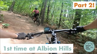
A fun trail for intermediate riders. Large turns with big downhills and uphills and plenty of log and root features to practice on. Ends on doubletrack heading beside the Marsh.

Trail Supporters

Recent Activity on Trail

Past Week
  • 21 rides
  • 15 miles average
6 Months
  • 95 rides
  • 13 miles avg distance
All
  • 1,967 rides
  • Last: Jun 9, 2026
c1c2c3c4
January
February
March
April
May
June
July
August
September
October
November
December
update trails status or condition

Gnarly Berms Trail Reports

statusdatedescription
Apr 26, 2026 @ 10:07am (America/Toronto)
Apr 26, 2026
It has been improved so much. The new berms are great.
Jan 4, 2026 @ 2:35pm (America/Toronto)
Jan 4, 2026
Nov 29, 2025 @ 4:36pm (America/Toronto)
Nov 29, 2025
New berms are awesome, frozen, quite a bit of leaf fall at start, Couple trees down, a climb under (bare fir) and ride around (small)
Nov 11, 2025 @ 4:17pm (America/Toronto)
Nov 11, 2025
reporter
Oct 1, 2025 @ 3:53pm (America/Toronto)
Oct 1, 2025
reporter Trail closed for refurnishment
more »
Status:
on Apr 26, 2026
Ideal
Avg: 4.46 (9 votes)
Your vote: 0

view (10,063)
close
3D
Trail Conditions
  • Unknown
  • Snow Groomed
  • Snow Packed
  • Snow Covered
  • Snow Cover Partial
  • Freeze/thaw Cycle
  • Icy
  • Prevalent Mud
  • Wet
  • Variable
  • Ideal
  • Dry
  • Very Dry
Trail Flow (Ridden Direction)
Trailforks scans users ridelogs to determine the most popular direction each trail is ridden. A good flowing trail network will have most trails flowing in a single direction according to their intension.
The colour categories are based on what percentage of riders are riding a trail in its intended direction.
  • > 96%
  • > 90%
  • > 80%
  • > 70%
  • > 50%
  • < 50%
  • bi-directional trail
  • no data
Trail Last Ridden
Trailforks scans ridelogs to determine the last time a trail was ridden.
  • < 2 days
  • < 1 week
  • < 2 weeks
  • < 1 month
  • < 6 months
  • > 6 months
Trail Ridden Direction
The intended direction a trail should be ridden.
  • Downhill Only
  • Downhill Primary
  • Both Directions
  • Uphill Primary
  • Uphill Only
  • One Direction
Contribute Details
Colors indicate trail is missing specified detail.
  • Description
  • Photos
  • Description & Photos
  • Videos
Trail Popularity ?
Trailforks scans ridelogs to determine which trails are ridden the most in the last 9 months. Trails are compared with nearby trails in the same city region with a possible 25 colour shades. Think of this as a heatmap, more rides = more kinetic energy = warmer colors.
  • most popular
  • popular
  • less popular
  • not popular
ATV/ORV/OHV Filter
Max Vehicle Width
inches
US Cell Coverage
Legend
cell carrier legend

Radar Time
Activity Recordings
Trailforks uses anonymized public activity data. ?
Activity Recordings
Trailforks uses anonymized public activity data. ?
Personal Heatmap
Activity Types
all / none
Options
2
Date range month
Winter Trails
Warning A routing network for winter maps does not exist. Selecting trails using the winter trails layer has been disabled.
Missing Trails
Most Popular
Least Popular
Trails are colored based on popularity. The more popular a trail is, the more red. Less popular trails trend towards green.
Jump Magnitude Heatmap
Heatmap of where riders jump on trails. Zoom in to see individual jumps, click circles to view jump details.
BC Backroad Status

Service Road Atlas is a free to use, community-driven service for viewing and creating reports on the numerous back-country service roads around B.C. and Alberta.

map legend
Slope Aspect
Direction the slope faces
Flat N NE E SE S SW W NW
Trails Deemphasized
Trails are shown in grey.
disable
Only show trails with no bike usage.
Enable
Suggested Layers
Based on selected activity type

    Save the current map location and zoom level as your default home location whenever this page is loaded.

    Save
        Directions to gnarly-berms trailhead (43.923590, -79.824030)

        Photos

        5 more »
        200 |
        Sep 10, 2021 @ 11:04am
        Sep 10, 2021
        420 |
        Jul 26, 2017 @ 9:27am
        Jul 26, 2017
        392 |
        Jul 23, 2017 @ 6:42pm
        Jul 23, 2017
        349 |
        Jul 23, 2017 @ 6:40pm
        Jul 23, 2017

        Videos

        1 more »
        Albion Hills - Gnarly Berms
        15:06 | 260 | Aug 30, 2022 , Caledon

        Routes with this trail

        5.0 14 miles 1,414 ft 92 Loop
        A loop around all the main trails at Albion Hills ending with a lung-busting climb up The Green Monster!
        11 miles 1,154 ft 23
        Did you like TENET, All AlbioN NoiblA style enjoy your most memorable Albion Hills moments Retrograde best...
        35 miles 3,191 ft 40
        A really fun link up of the three trails systems, Albion Hills, Palgrave, and Glen Haffy. It has a bit of...

        1 Review & Comments


        We hope you've been enjoying Trailforks!

        Create a FREE account to view trail comments and much more.

        • By hipposauceTF Pro & contributors
        • #17444 - 2,801 views

        Frequently Asked Questions About Gnarly Berms

        Where is Gnarly Berms located?
        Gnarly Berms is located in Albion Hills, Caledon, Ontario, Canada. It is part of the Albion Hills trail network. The trailhead is located at coordinates 43.92359, -79.82403.
        How hard is Gnarly Berms?
        Gnarly Berms is rated as Blue difficulty. The physical rating is Moderate. The average grade is 2.1%. The climb difficulty is rated Blue.
        What is the elevation gain for Gnarly Berms?
        Gnarly Berms has 67 ft of elevation gain. The trail has 136 ft of elevation descent. The elevation ranges from 930 ft to 999 ft.
        How long is Gnarly Berms?
        Gnarly Berms is 3,323 ft long. The trail type is singletrack.

        Hit the Trail

        Open in App

        Get this trail on your phone instantly.
        open trail in app

        Download Trail

        Save to wishlist, Garmin & download.
        save the trail

        Find Related Routes

        Find routes and users activities that include this trail.
        find routes for this trail

        You must enter a description before submitting.