more stats
3,402 ft
Distance
7 ft
Climb
-642 ft
Descent
00:10:04
Avg time
-635 ft
Altitude change
1,029 ft
Altitude min
1,664 ft
Altitude max
1,664 ft
Altitude start
1,029 ft
Altitude end
-18.668%
Grade
-41.535%
Grade max
4.562%
Grade min
166 ft
Distance climb
3,148 ft
Distance down
88 ft
Distance flat
00:10:04
Avg time

Gnarnia Details

  • Activities
    • Mountain Bike
  • Riding Area
    Exchequer Mountain Bike Park
    Merced, California
  • Difficulty Rating
  • Voted Difficulty
    Double Black Diamond (2 votes)
  • Local Popularity
    70 in Mountain Biking
  • Global Ranking
    #76786 in Mountain Biking
  • Trail Type
    Singletrack
  • Bike Type
    DH, AM
  • Direction
    Downhill Primary
    Popular Direction Shown
  • Dogs Allowed
    Yes
  • TTFs on Trail
    Berm, Drop, Jump, Gap Jump, Rock Face, Rock Garden
  • Year Opened
    2017

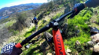
Gnarnia is challenging DH run. The terrain is rough and raw with features including drops, steeps, jumps, gaps, rocks, and berms. Hiking or sessioning the trail first is highly recommended.

Disclaimer

Look before you leap. Ride within your ability.

Local Trail Association
Traditionally Indigenous Territory

Recent Activity on Trail

Past Week
  • 0 rides
  •  
6 Months
  • 19 rides
  • 14 miles avg distance
All
  • 67 rides
  • Last: May 29, 2026
c1c2c3c4
January
February
March
April
May
June
July
August
September
October
November
December
update trails status or condition

Gnarnia Trail Reports

statusdatedescription
Mar 4, 2025 @ 1:31pm
Mar 4, 2025
Oct 16, 2023 @ 10:42am
Oct 16, 2023
Dry conditions
Feb 18, 2023 @ 10:39pm
Feb 18, 2023
Puddle halfway down
Jan 10, 2022 @ 8:21am
Jan 10, 2022
sometimes perfect dirt, other times rutted and muddy. needs catch berm work in some places.
Nov 26, 2021 @ 8:57pm
Nov 26, 2021
more »
Status:
on Mar 4, 2025
Dry
Avg: 4.04 (18 votes)
Your vote: 0

view (653)
close
3D
Trail Conditions
  • Unknown
  • Snow Groomed
  • Snow Packed
  • Snow Covered
  • Snow Cover Partial
  • Freeze/thaw Cycle
  • Icy
  • Prevalent Mud
  • Wet
  • Variable
  • Ideal
  • Dry
  • Very Dry
Trail Flow (Ridden Direction)
Trailforks scans users ridelogs to determine the most popular direction each trail is ridden. A good flowing trail network will have most trails flowing in a single direction according to their intension.
The colour categories are based on what percentage of riders are riding a trail in its intended direction.
  • > 96%
  • > 90%
  • > 80%
  • > 70%
  • > 50%
  • < 50%
  • bi-directional trail
  • no data
Trail Last Ridden
Trailforks scans ridelogs to determine the last time a trail was ridden.
  • < 2 days
  • < 1 week
  • < 2 weeks
  • < 1 month
  • < 6 months
  • > 6 months
Trail Ridden Direction
The intended direction a trail should be ridden.
  • Downhill Only
  • Downhill Primary
  • Both Directions
  • Uphill Primary
  • Uphill Only
  • One Direction
Contribute Details
Colors indicate trail is missing specified detail.
  • Description
  • Photos
  • Description & Photos
  • Videos
Trail Popularity ?
Trailforks scans ridelogs to determine which trails are ridden the most in the last 9 months. Trails are compared with nearby trails in the same city region with a possible 25 colour shades. Think of this as a heatmap, more rides = more kinetic energy = warmer colors.
  • most popular
  • popular
  • less popular
  • not popular
ATV/ORV/OHV Filter
Max Vehicle Width
inches
US Cell Coverage
Legend
cell carrier legend

Radar Time
Activity Recordings
Trailforks uses anonymized public activity data. ?
Activity Recordings
Trailforks uses anonymized public activity data. ?
Personal Heatmap
Activity Types
all / none
Options
2
Date range month
Winter Trails
Warning A routing network for winter maps does not exist. Selecting trails using the winter trails layer has been disabled.
Missing Trails
Most Popular
Least Popular
Trails are colored based on popularity. The more popular a trail is, the more red. Less popular trails trend towards green.
Jump Magnitude Heatmap
Heatmap of where riders jump on trails. Zoom in to see individual jumps, click circles to view jump details.
BC Backroad Status

Service Road Atlas is a free to use, community-driven service for viewing and creating reports on the numerous back-country service roads around B.C. and Alberta.

map legend
Slope Aspect
Direction the slope faces
Flat N NE E SE S SW W NW
Trails Deemphasized
Trails are shown in grey.
disable
Only show trails with no bike usage.
Enable
Suggested Layers
Based on selected activity type

    Save the current map location and zoom level as your default home location whenever this page is loaded.

    Save
        Directions to gnarnia trailhead (37.627080, -120.300020)

        Photos

        15 more »
        636 |
        Apr 17, 2019 @ 11:33pm
        Apr 17, 2019
        613 |
        Apr 17, 2019 @ 11:17pm
        Apr 17, 2019
        66 |
        Apr 22, 2025 @ 9:38pm
        Apr 22, 2025
        70 |
        Apr 22, 2025 @ 9:38pm
        Apr 22, 2025

        Videos

        7 more »
        youtuber Exchequer Bike Trails (Mariposa County, CA)...
        16:25 | 1023 | Jan 23, 2018 , Merced
        youtuber I MADE IT TO GNARNIA | Exchequer Mountain Bike...
        15:54 | 1310 | Mar 2, 2018 , Merced
        Exchequer Enduro 2022 Gnarnia
        3:44 | 447 | Apr 7, 2022 , Merced
        Exchequer: The Comicals of Gnarnia
        2:59 | 450 | Apr 14, 2021 , Merced

        Routes with this trail

        8 miles 1,657 ft 5
        exchequer enduro: https://www.bearraceevents.com/exchequerextravaganza
        3,891 ft 1 Race
        SJSU Proline Downhill Race Course

        3 Reviews & Comments


        We hope you've been enjoying Trailforks!

        Create a FREE account to view trail comments and much more.

        • By bchristiTF Pro & contributors
        • #81960 - 7,167 views

        Frequently Asked Questions About Gnarnia

        Where is Gnarnia located?
        Gnarnia is located in Exchequer Mountain Bike Park, Merced, California, United States. It is part of the Exchequer Mountain Bike Park trail network. The trailhead is located at coordinates 37.62708, -120.30002.
        How hard is Gnarnia?
        Gnarnia is rated as Double Black Diamond difficulty. The average grade is 18.668%.
        What is the elevation gain for Gnarnia?
        Gnarnia has 7 ft of elevation gain. The trail has 642 ft of elevation descent. The elevation ranges from 1,029 ft to 1,664 ft.
        Is Gnarnia a point to point trail?
        Gnarnia is not a point to point trail. The direction is Downhill Primary. The trail type is singletrack.

        Hit the Trail

        Open in App

        Get this trail on your phone instantly.
        open trail in app

        Download Trail

        Save to wishlist, Garmin & download.
        save the trail

        Find Related Routes

        Find routes and users activities that include this trail.
        find routes for this trail

        You must enter a description before submitting.