more stats
1,453 ft
Distance
-164 ft
Descent
00:02:48
Avg time
-165 ft
Altitude change
546 ft
Altitude min
711 ft
Altitude max
711 ft
Altitude start
545 ft
Altitude end
-11.4%
Grade
-28%
Grade max
-1%
Grade min
46 ft
Distance climb
1,371 ft
Distance down
36 ft
Distance flat
00:02:48
Avg time

Goblin Details

  • Activities
    • Mountain Bike
    • E-Bike
    • Winter Fat Bike
  • Riding Area
    Balquhidder
    Strathyre
  • Difficulty Rating
  • Local Popularity
    70 in Mountain Biking [+]
    • 80 in E-Biking
  • Global Ranking
    #68955 in Mountain Biking [+]
    • #23564 in E-Biking
  • Trail Type
    Singletrack
  • Bike Type
    AM, XC, DJ, Fat
  • Climb Difficulty
    Blue
  • Physical Rating
    Moderate
  • Trail Visibility
    Always easy to follow
  • Season
    All year
  • Dogs Allowed
    Yes
  • eBike Allowed
    Yes up to Class 1
  • TTFs on Trail
    Berm, Bridge, Drop, Jump, Rock Face
  • Ride in Rain
    Yes
  • Land Owner
    Forestry And Land Scotland

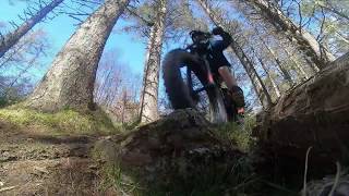
The Goblin is a great wee techy and scenic trail pretty much right behind the Kirk in Balquhidder. Simply ride up the steep forestry track behind the church about 300 metres to access the trail head on your left. (It's about 50 metres before the water pumping station building on your right).
The trail is loamy rooty and rocky underwheel. There is a small rock drop at the start (which sets the level of technical ability required). Its fast and flowy most of the way with some interesting rock features, bridges and drops next to the ravine on your right. Take care when riding close to the ravine - particularly at the final rock bridge and over rooty sections where a fall rightwards will send you down a 10metre rocky drop into the burn!
Top Tips: At th eend of the trail turn right towards the waterfall for a photo opp... and then if you're into it, once you come out by the Church pay a quick visit to Rob Roy's Grave for a bit of history and culture! (Look up "Rob Roy" for the story online...)

Access Info

From the back of Balquhidder Kirk Ride 400m up the steep forestry track. It's on your left as the track levels off (50m before the water pumping station building on your right)

Local Trail Association

Recent Activity on Trail

Past Week
  • 0 rides
  •  
6 Months
  • 6 rides
  • 10 miles avg distance
All
  • 29 rides
  • Last: May 31, 2026
c1c2c3c4
January
February
March
April
May
June
July
August
September
October
November
December
update trails status or condition

Goblin Trail Reports

statusdatedescription
Nov 6, 2025 @ 12:21pm (Europe/London)
Nov 6, 2025
fallen tree near river.
Feb 15, 2025 @ 4:50am
Feb 15, 2025
all clear after storm
Mar 31, 2023 @ 8:07pm
Mar 31, 2023
Dec 25, 2022 @ 7:18am
Dec 25, 2022
Tree down blocking the trail about 3/4 of the way down, easily spotted. Possible to walk round but very boggy and crumbly ground.
Dec 5, 2022 @ 8:00pm
Dec 5, 2022
more »
Status:
on Nov 6, 2025
Avg: 4.33 (7 votes)
Your vote: 0

view (501)
close
3D
Trail Conditions
  • Unknown
  • Snow Groomed
  • Snow Packed
  • Snow Covered
  • Snow Cover Partial
  • Freeze/thaw Cycle
  • Icy
  • Prevalent Mud
  • Wet
  • Variable
  • Ideal
  • Dry
  • Very Dry
Trail Flow (Ridden Direction)
Trailforks scans users ridelogs to determine the most popular direction each trail is ridden. A good flowing trail network will have most trails flowing in a single direction according to their intension.
The colour categories are based on what percentage of riders are riding a trail in its intended direction.
  • > 96%
  • > 90%
  • > 80%
  • > 70%
  • > 50%
  • < 50%
  • bi-directional trail
  • no data
Trail Last Ridden
Trailforks scans ridelogs to determine the last time a trail was ridden.
  • < 2 days
  • < 1 week
  • < 2 weeks
  • < 1 month
  • < 6 months
  • > 6 months
Trail Ridden Direction
The intended direction a trail should be ridden.
  • Downhill Only
  • Downhill Primary
  • Both Directions
  • Uphill Primary
  • Uphill Only
  • One Direction
Contribute Details
Colors indicate trail is missing specified detail.
  • Description
  • Photos
  • Description & Photos
  • Videos
Trail Popularity ?
Trailforks scans ridelogs to determine which trails are ridden the most in the last 9 months. Trails are compared with nearby trails in the same city region with a possible 25 colour shades. Think of this as a heatmap, more rides = more kinetic energy = warmer colors.
  • most popular
  • popular
  • less popular
  • not popular
ATV/ORV/OHV Filter
Max Vehicle Width
inches
US Cell Coverage
Legend
cell carrier legend

Radar Time
Activity Recordings
Trailforks uses anonymized public activity data. ?
Activity Recordings
Trailforks uses anonymized public activity data. ?
Personal Heatmap
Activity Types
all / none
Options
2
Date range month
Winter Trails
Warning A routing network for winter maps does not exist. Selecting trails using the winter trails layer has been disabled.
Missing Trails
Most Popular
Least Popular
Trails are colored based on popularity. The more popular a trail is, the more red. Less popular trails trend towards green.
Jump Magnitude Heatmap
Heatmap of where riders jump on trails. Zoom in to see individual jumps, click circles to view jump details.
BC Backroad Status

Service Road Atlas is a free to use, community-driven service for viewing and creating reports on the numerous back-country service roads around B.C. and Alberta.

map legend
Slope Aspect
Direction the slope faces
Flat N NE E SE S SW W NW
Trails Deemphasized
Trails are shown in grey.
disable
Only show trails with no bike usage.
Enable
Suggested Layers
Based on selected activity type

    Save the current map location and zoom level as your default home location whenever this page is loaded.

    Save
        Directions to goblin trailhead (56.361600, -4.375260)

        Photos

        1 more »
        109 |
        Feb 5, 2021 @ 5:46am
        Feb 5, 2021

        Videos

        2 more »
        Balquhidder MTB Trails - The GOBLIN Singletrack
        0:47 | 214 | Sep 11, 2020 , Strathyre
        Balquhidder MTB Trails - The GOBLIN Singletrack
        231 | May 17, 2020 , Strathyre

        2 Reviews & Comments


        We hope you've been enjoying Trailforks!

        Create a FREE account to view trail comments and much more.

        • By gav-sTF Pro & contributors
        • #101208 - 1,512 views

        Frequently Asked Questions About Goblin

        Where is Goblin located?
        Goblin is located in Balquhidder, Strathyre, United Kingdom. It is part of the Balquhidder trail network. The trailhead is located at coordinates 56.3616, -4.37526.
        How hard is Goblin?
        Goblin is rated as Red difficulty. The physical rating is Moderate. The average grade is 11.4%. The climb difficulty is rated Blue.
        What is the elevation gain for Goblin?
        The trail has 50 m of elevation descent. The elevation ranges from 166 m to 217 m.
        How long is Goblin?
        Goblin is 443.0 m long. The trail type is singletrack.

        Hit the Trail

        Open in App

        Get this trail on your phone instantly.
        open trail in app

        Download Trail

        Save to wishlist, Garmin & download.
        save the trail

        Find Related Routes

        Find routes and users activities that include this trail.
        find routes for this trail

        You must enter a description before submitting.