more stats
2.9 miles
Distance
106 ft
Climb
-1,045 ft
Descent
00:09:07
Avg time
-941 ft
Altitude change
7,115 ft
Altitude min
8,056 ft
Altitude max
8,056 ft
Altitude start
7,116 ft
Altitude end
-6.1%
Grade
-37.9%
Grade max
36.6%
Grade min
1,578 ft
Distance climb
2 miles
Distance down
2,260 ft
Distance flat
00:09:07
Avg time

Going Green Details

  • Activities
    • Mountain Bike
    • E-Bike
    • Hike
    • Trail Running
  • Riding Area
    Snow Summit Bike Park
    Big Bear City, California
  • Difficulty Rating
  • Voted Difficulty
    Green (5 votes)
  • Local Popularity
    65 in Mountain Biking [+]
    • 45 in E-Biking
    • 65 in Trail Running
    • 50 in Hiking
  • Global Ranking
    #59498 in Mountain Biking [+]
    • #75288 in E-Biking
    • #49391 in Trail Running
    • #81729 in Hiking
  • Hiking SAC Scale
    T1 Hiking
  • Trail Type
    Singletrack
  • Bike Type
    DH, AM, XC
  • Climb Difficulty
    Green
  • Physical Rating
    Easy
  • Trail Visibility
    Always easy to follow
  • Season
    May-Sept
  • Dogs Allowed
    Yes
  • eBike Allowed
    Yes up to Class 1
  • TTFs on Trail
    Berm, Jump, Rock Garden, Other
  • Ride in Rain
    Yes
  • Year Opened
    2016
  • Land Owner
    Snow Summit

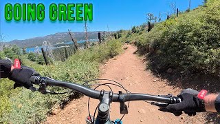
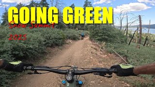
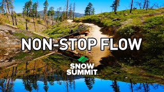
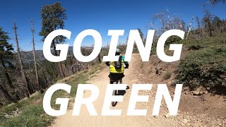
A fun trail for riders of all abilities. This trail introduces riders to new features such as berms, paver stones, rock gardens, and rollers. It also helps riders that are looking to get better at jumping as there are a few opportunities scattered along the trail and some small step downs near the top of the trail. Novice riders should beware that the trail does have rocky and moderately steep sections. This trail, nor any trail at Snow Summit, is not recommended for riders with no experience riding mountain bikes.
The trail intersects Towne Trail at the bottom. The rider is automatically pointed in the correct direction back to the base of Snow Summit for another lift ride to the top. Beware of hikers and families on Towne Trail - it isn't a bike specific trail.

Access Info

Follow posted signs from either lift to the trail head. Two possible routes from west lift and one route from the east lift.

Disclaimer

NOTE: this trail is considered downhill primary; however, outside of bike park operating hours it is a bi-directional trail and is also open to other forms of outdoor recreation: hikers, walkers, trail runners, backpackers, etc.

Trail Supporters

  • USFS
    Land Manager

Bike Park

Local Trail Association
Traditionally Indigenous Territory

Recent Activity on Trail

Past Week
  • 11 rides
  • 22 miles average
6 Months
  • 35 rides
  • 23 miles avg distance
All
  • 566 rides
  • Last: Jun 18, 2026
c1c2c3c4
January
February
March
April
May
June
July
August
September
October
November
December
update trails status or condition

Going Green Trail Reports

statusdatedescription
Mar 27, 2026 @ 2:29pm (America/Los_Angeles)
Mar 27, 2026
Rode the lower half and it was really good.
Sep 28, 2025 @ 2:23pm (America/Los_Angeles)
Sep 28, 2025
Long ride..smooth and fast
Aug 16, 2025 @ 8:16am
Aug 16, 2025
Great for novice or warm up. If you're a DH purist then expect some pedaling, but not much. Snow Summit has vastly improved signage over the...
Jul 4, 2025 @ 5:30pm
Jul 4, 2025
Very nice flow trail perfect for beginners. I’m an advanced rider and took my 2 year old on it and was ok. I would say this is more of a green...
Jun 22, 2025 @ 8:37pm
Jun 22, 2025
Brake bump season
more »
Status:
on Mar 27, 2026
Ideal
Avg: 4.3 (17 votes)
Your vote: 0

view (6,565)
close
3D
Trail Conditions
  • Unknown
  • Snow Groomed
  • Snow Packed
  • Snow Covered
  • Snow Cover Partial
  • Freeze/thaw Cycle
  • Icy
  • Prevalent Mud
  • Wet
  • Variable
  • Ideal
  • Dry
  • Very Dry
Trail Flow (Ridden Direction)
Trailforks scans users ridelogs to determine the most popular direction each trail is ridden. A good flowing trail network will have most trails flowing in a single direction according to their intension.
The colour categories are based on what percentage of riders are riding a trail in its intended direction.
  • > 96%
  • > 90%
  • > 80%
  • > 70%
  • > 50%
  • < 50%
  • bi-directional trail
  • no data
Trail Last Ridden
Trailforks scans ridelogs to determine the last time a trail was ridden.
  • < 2 days
  • < 1 week
  • < 2 weeks
  • < 1 month
  • < 6 months
  • > 6 months
Trail Ridden Direction
The intended direction a trail should be ridden.
  • Downhill Only
  • Downhill Primary
  • Both Directions
  • Uphill Primary
  • Uphill Only
  • One Direction
Contribute Details
Colors indicate trail is missing specified detail.
  • Description
  • Photos
  • Description & Photos
  • Videos
Trail Popularity ?
Trailforks scans ridelogs to determine which trails are ridden the most in the last 9 months. Trails are compared with nearby trails in the same city region with a possible 25 colour shades. Think of this as a heatmap, more rides = more kinetic energy = warmer colors.
  • most popular
  • popular
  • less popular
  • not popular
ATV/ORV/OHV Filter
Max Vehicle Width
inches
US Cell Coverage
Legend
cell carrier legend

Radar Time
Activity Recordings
Trailforks uses anonymized public activity data. ?
Activity Recordings
Trailforks uses anonymized public activity data. ?
Personal Heatmap
Activity Types
all / none
Options
2
Date range month
Winter Trails
Warning A routing network for winter maps does not exist. Selecting trails using the winter trails layer has been disabled.
Missing Trails
Most Popular
Least Popular
Trails are colored based on popularity. The more popular a trail is, the more red. Less popular trails trend towards green.
Jump Magnitude Heatmap
Heatmap of where riders jump on trails. Zoom in to see individual jumps, click circles to view jump details.
BC Backroad Status

Service Road Atlas is a free to use, community-driven service for viewing and creating reports on the numerous back-country service roads around B.C. and Alberta.

map legend
Slope Aspect
Direction the slope faces
Flat N NE E SE S SW W NW
Trails Deemphasized
Trails are shown in grey.
disable
Only show trails with no bike usage.
Enable
Suggested Layers
Based on selected activity type

    Save the current map location and zoom level as your default home location whenever this page is loaded.

    Save
        Directions to going-green trailhead (34.222430, -116.893970)

        Photos

        15 more »
        38 |
        Aug 19, 2025 @ 9:53am
        Aug 19, 2025
        49 |
        Aug 16, 2025 @ 8:16am
        Aug 16, 2025
        176 |
        Sep 8, 2019 @ 8:47am
        Sep 8, 2019
        162 |
        Jul 15, 2018 @ 12:57am
        Jul 15, 2018

        Videos

        16 more »
        youtuber Going Green Trail - Snow Summit Bike Park - 7/2025
        13:22 | 93 | Jul 10, 2025 , Big Bear City
        youtuber Going Green 'Beginner' Trail Snow Summit Bike...
        14:45 | 154 | Jul 29, 2025 , Big Bear City
        youtuber Snow Summit's Beginner Trail - Going Green [...
        11:21 | 363 | Aug 25, 2021 , Big Bear City
        youtuber Going Green MTB Trail | Snow Summit Bike Park...
        19:11 | 643 | Jul 26, 2020 , Big Bear City

        Trail Lists

        9 Reviews & Comments


        We hope you've been enjoying Trailforks!

        Create a FREE account to view trail comments and much more.

        • By socalstokieTF Pro & contributors
        • #62618 - 6,025 views

        Frequently Asked Questions About Going Green

        Where is Going Green located?
        Going Green is located in Snow Summit Bike Park, Big Bear City, California, United States. It is part of the Snow Summit Bike Park trail network. The trailhead is located at coordinates 34.22243, -116.89397.
        How hard is Going Green?
        Going Green is rated as Green difficulty. The physical rating is Easy. The average grade is 6.1%. The climb difficulty is rated Green.
        What is the elevation gain for Going Green?
        Going Green has 106 ft of elevation gain. The trail has 1,045 ft of elevation descent. The elevation ranges from 7,115 ft to 8,056 ft.
        How long is Going Green?
        Going Green is 2.9 miles long. The trail type is singletrack.

        Hit the Trail

        Open in App

        Get this trail on your phone instantly.
        open trail in app

        Download Trail

        Save to wishlist, Garmin & download.
        save the trail

        Find Related Routes

        Find routes and users activities that include this trail.
        find routes for this trail

        You must enter a description before submitting.