more stats
1.5 miles
Distance
32 ft
Climb
-564 ft
Descent
00:14:00
Avg time
-532 ft
Altitude change
1,204 ft
Altitude min
1,737 ft
Altitude max
1,737 ft
Altitude start
1,204 ft
Altitude end
-6.7%
Grade
-39.1%
Grade max
10.8%
Grade min
679 ft
Distance climb
1 mile
Distance down
942 ft
Distance flat
00:14:00
Avg time

Gold Digger Details

  • Activities
    • Mountain Bike
    • Hike
    • Trail Running
  • Riding Area
    7 Mile Riding Area
    Queenstown
  • Difficulty Rating
  • Local Popularity
    50 in Mountain Biking [+]
    • 40 in Trail Running
    • 45 in Hiking
  • Global Ranking
    #73792 in Mountain Biking [+]
    • #129428 in Trail Running
    • #102941 in Hiking
  • Trail Type
    Singletrack
  • Bike Type
    AM, XC
  • Climb Difficulty
    Blue
  • Physical Rating
    Hard
  • Season
    Oct - June
  • Dogs Allowed
    Yes
  • Year Opened
    2012
  • Land Owner
    DOC

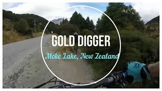
2 way single track out and back or as part of Moke Lake loop through gold mining remains from 7mile creek car park to the 4WD Road to Moke Lake. Trail is narrow in places and has some exposure to tracks edge. Trail is best ridden as a climb towards Moke Lake. Give way to uphill riders.

Access Info

Drive/ride towards Genorchy from Queenstown trail starts opposit the 7 Mile Creek carpark next to the Moke Lake Rd intersection.

Local Trail Association
Traditionally Indigenous Territory

Recent Activity on Trail

Past Week
  • 0 rides
  •  
6 Months
  • 16 rides
  • 20 miles avg distance
All
  • 137 rides
  • Last: Jun 6, 2026
c1c2c3c4
January
February
March
April
May
June
July
August
September
October
November
December
update trails status or condition

Gold Digger Trail Reports

statusdatedescription
May 26, 2026 @ 8:42am (Pacific/Auckland)
May 25, 2026
Whole trail cut back and blown ready for winter
Jan 13, 2026 @ 6:30pm (Pacific/Auckland)
Jan 12, 2026
Creek has scoured and cut into the bank. Needs a small gabion basket to protect. Midway on gold digger.
Jan 11, 2026 @ 7:54pm (Pacific/Auckland)
Jan 10, 2026
Needs a vegetation cut back and spray bracken General blow and rake
Oct 2, 2025 @ 6:26pm (Pacific/Auckland)
Oct 1, 2025
Sep 24, 2025 @ 3:57pm (Pacific/Auckland)
Sep 23, 2025
Track needs a spring rake and blow. Some drains to clear. Chicken wire to be replaced on one of the bridges.
more »
Status:
on May 26, 2026
Variable
Avg: 4.13 (18 votes)
Your vote: 0

view (1,288)
close
3D
Trail Conditions
  • Unknown
  • Snow Groomed
  • Snow Packed
  • Snow Covered
  • Snow Cover Partial
  • Freeze/thaw Cycle
  • Icy
  • Prevalent Mud
  • Wet
  • Variable
  • Ideal
  • Dry
  • Very Dry
Trail Flow (Ridden Direction)
Trailforks scans users ridelogs to determine the most popular direction each trail is ridden. A good flowing trail network will have most trails flowing in a single direction according to their intension.
The colour categories are based on what percentage of riders are riding a trail in its intended direction.
  • > 96%
  • > 90%
  • > 80%
  • > 70%
  • > 50%
  • < 50%
  • bi-directional trail
  • no data
Trail Last Ridden
Trailforks scans ridelogs to determine the last time a trail was ridden.
  • < 2 days
  • < 1 week
  • < 2 weeks
  • < 1 month
  • < 6 months
  • > 6 months
Trail Ridden Direction
The intended direction a trail should be ridden.
  • Downhill Only
  • Downhill Primary
  • Both Directions
  • Uphill Primary
  • Uphill Only
  • One Direction
Contribute Details
Colors indicate trail is missing specified detail.
  • Description
  • Photos
  • Description & Photos
  • Videos
Trail Popularity ?
Trailforks scans ridelogs to determine which trails are ridden the most in the last 9 months. Trails are compared with nearby trails in the same city region with a possible 25 colour shades. Think of this as a heatmap, more rides = more kinetic energy = warmer colors.
  • most popular
  • popular
  • less popular
  • not popular
ATV/ORV/OHV Filter
Max Vehicle Width
inches
US Cell Coverage
Legend
cell carrier legend

Radar Time
Activity Recordings
Trailforks uses anonymized public activity data. ?
Activity Recordings
Trailforks uses anonymized public activity data. ?
Personal Heatmap
Activity Types
all / none
Options
2
Date range month
Winter Trails
Warning A routing network for winter maps does not exist. Selecting trails using the winter trails layer has been disabled.
Missing Trails
Most Popular
Least Popular
Trails are colored based on popularity. The more popular a trail is, the more red. Less popular trails trend towards green.
Jump Magnitude Heatmap
Heatmap of where riders jump on trails. Zoom in to see individual jumps, click circles to view jump details.
BC Backroad Status

Service Road Atlas is a free to use, community-driven service for viewing and creating reports on the numerous back-country service roads around B.C. and Alberta.

map legend
Slope Aspect
Direction the slope faces
Flat N NE E SE S SW W NW
Trails Deemphasized
Trails are shown in grey.
disable
Only show trails with no bike usage.
Enable
Suggested Layers
Based on selected activity type

    Save the current map location and zoom level as your default home location whenever this page is loaded.

    Save
        Directions to gold-digger trailhead (-45.044890, 168.589810)

        Photos

        44 more »
        184 |
        Jun 15, 2019 @ 11:29pm
        Jun 15, 2019
        19 |
        May 25, 2026 @ 1:42pm
        May 25, 2026
        22 |
        May 25, 2026 @ 1:42pm
        May 25, 2026
        17 |
        May 25, 2026 @ 1:42pm
        May 25, 2026

        Videos

        5 more »
        youtuber Gold Digger Trail / New Zealand (Follow Cam)
        5:21 | 1095 | Mar 29, 2017 , Queenstown
        7 mile Gold Digger | Bike Travel Destination...
        8:59 | 797 | Jul 29, 2019 , Queenstown
        Gold Digger Track - Queenstown - NZ by Hugo
        629 | Apr 20, 2017 , Queenstown
        Gold Digger Track - Queenstown - NZ by Hugo
        990 | Nov 5, 2016 , Queenstown

        Routes with this trail

        1.0 15 miles 2,342 ft 7 Loop
        Classic Queenstown backountry loop sometimes called the 'Four Lakes' ride, start at either Wilson Bay or 7...
        185 miles 39,064 ft 36
        Starting in Tāhuna , heading on bike path to Frankton ,taking in Remarkables, before returning to bike...

        Reviews / Comments

        No reviews yet, be the first to write a review or ask a question.
        Use trail reports to comment on trail conditions.


        We hope you've been enjoying Trailforks!

        Create a FREE account to view trail comments and much more.

        • By BrendhanTF Pro QMTBC & contributors
        • #24301 - 11,184 views

        Frequently Asked Questions About Gold Digger

        Where is Gold Digger located?
        Gold Digger is located in 7 Mile Riding Area, Queenstown, New Zealand. It is part of the 7 Mile Riding Area trail network. The trailhead is located at coordinates -45.04489, 168.58981.
        How hard is Gold Digger?
        Gold Digger is rated as Blue difficulty. The physical rating is Hard. The average grade is 6.7%. The climb difficulty is rated Blue.
        What is the elevation gain for Gold Digger?
        Gold Digger has 32 ft of elevation gain. The trail has 564 ft of elevation descent. The elevation ranges from 1,204 ft to 1,737 ft.
        How long is Gold Digger?
        Gold Digger is 1.5 miles long. The trail type is singletrack.

        Hit the Trail

        Open in App

        Get this trail on your phone instantly.
        open trail in app

        Download Trail

        Save to wishlist, Garmin & download.
        save the trail

        Find Related Routes

        Find routes and users activities that include this trail.
        find routes for this trail

        You must enter a description before submitting.