more stats
3,376 ft
Distance
15 ft
Climb
-260 ft
Descent
00:04:52
Avg time
-246 ft
Altitude change
2,935 ft
Altitude min
3,186 ft
Altitude max
3,180 ft
Altitude start
2,936 ft
Altitude end
-7.3%
Grade
-23.8%
Grade max
12.4%
Grade min
413 ft
Distance climb
2,156 ft
Distance down
807 ft
Distance flat
00:04:52
Avg time

Golden Triangle Details

  • Activities
    • Mountain Bike
  • Riding Area
    Whistler Mountain Bike Park
    Whistler, British Columbia
  • Difficulty Rating
  • Voted Difficulty
    Double Black Diamond (3 votes)
  • Local Popularity
    50 in Mountain Biking
  • Global Ranking
    #53651 in Mountain Biking
  • Trail Type
    Singletrack
  • Bike Type
    DH, AM
  • Direction
    Downhill Only
    Popular Direction Shown
  • Land Owner

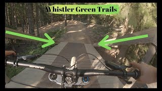
A fun flow trail accessed off EZ with many berms and rollers. A great way to practice gaining speed from pumping and turning. More rewarding and fun when using proper pumping and berm techniques together to create a "flowtastic" roller coaster like experience.

Bike Park

Recent Activity on Trail

Past Week
  • 20 rides
  • 22 miles average
6 Months
  • 74 rides
  • 19 miles avg distance
All
  • 1,625 rides
  • Last: Jun 9, 2026
c1c2c3c4
January
February
March
April
May
June
July
August
September
October
November
December
Status:
on May 15, 2026
Ideal
Avg: 3.48 (55 votes)
Your vote: 0

view (7,843)
close
3D
Trail Conditions
  • Unknown
  • Snow Groomed
  • Snow Packed
  • Snow Covered
  • Snow Cover Partial
  • Freeze/thaw Cycle
  • Icy
  • Prevalent Mud
  • Wet
  • Variable
  • Ideal
  • Dry
  • Very Dry
Trail Flow (Ridden Direction)
Trailforks scans users ridelogs to determine the most popular direction each trail is ridden. A good flowing trail network will have most trails flowing in a single direction according to their intension.
The colour categories are based on what percentage of riders are riding a trail in its intended direction.
  • > 96%
  • > 90%
  • > 80%
  • > 70%
  • > 50%
  • < 50%
  • bi-directional trail
  • no data
Trail Last Ridden
Trailforks scans ridelogs to determine the last time a trail was ridden.
  • < 2 days
  • < 1 week
  • < 2 weeks
  • < 1 month
  • < 6 months
  • > 6 months
Trail Ridden Direction
The intended direction a trail should be ridden.
  • Downhill Only
  • Downhill Primary
  • Both Directions
  • Uphill Primary
  • Uphill Only
  • One Direction
Contribute Details
Colors indicate trail is missing specified detail.
  • Description
  • Photos
  • Description & Photos
  • Videos
Trail Popularity ?
Trailforks scans ridelogs to determine which trails are ridden the most in the last 9 months. Trails are compared with nearby trails in the same city region with a possible 25 colour shades. Think of this as a heatmap, more rides = more kinetic energy = warmer colors.
  • most popular
  • popular
  • less popular
  • not popular
ATV/ORV/OHV Filter
Max Vehicle Width
inches
US Cell Coverage
Legend
cell carrier legend

Radar Time
Activity Recordings
Trailforks uses anonymized public activity data. ?
Activity Recordings
Trailforks uses anonymized public activity data. ?
Personal Heatmap
Activity Types
all / none
Options
2
Date range month
Winter Trails
Warning A routing network for winter maps does not exist. Selecting trails using the winter trails layer has been disabled.
Missing Trails
Most Popular
Least Popular
Trails are colored based on popularity. The more popular a trail is, the more red. Less popular trails trend towards green.
Jump Magnitude Heatmap
Heatmap of where riders jump on trails. Zoom in to see individual jumps, click circles to view jump details.
BC Backroad Status

Service Road Atlas is a free to use, community-driven service for viewing and creating reports on the numerous back-country service roads around B.C. and Alberta.

map legend
Slope Aspect
Direction the slope faces
Flat N NE E SE S SW W NW
Trails Deemphasized
Trails are shown in grey.
disable
Only show trails with no bike usage.
Enable
Suggested Layers
Based on selected activity type

    Save the current map location and zoom level as your default home location whenever this page is loaded.

    Save
        Directions to golden-triangle trailhead (50.099220, -122.962400)

        Photos

        69 more »
        70 |
        Sep 7, 2017 @ 10:05am
        Sep 7, 2017
        106 |
        Aug 13, 2017 @ 11:35am
        Aug 13, 2017
        360 |
        Sep 6, 2004 @ 7:46pm
        Sep 6, 2004
        350 |
        Sep 6, 2004 @ 7:46pm
        Sep 6, 2004

        Videos

        7 more »
        youtuber Easy Does It - Whistler Bike Park - Whistler, BC
        17:22 | 326 | Sep 26, 2022 , Whistler
        youtuber Golden Triangle - Whistler Bike Park -...
        4:03 | 364 | Sep 26, 2022 , Whistler
        Whistler Bike Park 2023 - Easy Does It, Golden...
        12:57 | 259 | Jun 20, 2023 , Whistler
        Whistler Bike Park Green Trails - Complete...
        12:13 | 418 | Jul 12, 2019 , Whistler

        Routes with this trail

        5.0 5 miles 21 ft 19
        A lap including , , and A-Line. Tech, berms and jumps.
        5 miles 1,249 ft 26
        Bike park Ride!! Start - Yellow gate at access road. Access Road UP Singing Pass UP to Crank it up...
        1.0 4 miles 657 ft 13
        Start at bottom of Whistler Bike Park Up main road to connect to Easy Does It all the way up to , Then...

        1 Review & Comments


        We hope you've been enjoying Trailforks!

        Create a FREE account to view trail comments and much more.

        • By Tekmisfit & contributors
        • #2480 - 6,420 views

        Frequently Asked Questions About Golden Triangle

        Where is Golden Triangle located?
        Golden Triangle is located in Whistler Mountain Bike Park, Whistler, British Columbia, Canada. It is part of the Whistler Mountain Bike Park trail network. The trailhead is located at coordinates 50.09922, -122.9624.
        How hard is Golden Triangle?
        Golden Triangle is rated as Green difficulty. The average grade is 7.3%.
        What is the elevation gain for Golden Triangle?
        Golden Triangle has 15 ft of elevation gain. The trail has 260 ft of elevation descent. The elevation ranges from 2,935 ft to 3,186 ft.
        Is Golden Triangle a point to point trail?
        Yes, Golden Triangle is a point to point trail. The direction is Downhill Only. The trail type is singletrack.

        Hit the Trail

        Open in App

        Get this trail on your phone instantly.
        open trail in app

        Download Trail

        Save to wishlist, Garmin & download.
        save the trail

        Find Related Routes

        Find routes and users activities that include this trail.
        find routes for this trail

        You must enter a description before submitting.