more stats
1.0 mile
Distance
188 ft
Climb
-235 ft
Descent
00:11:32
Avg time
-48 ft
Altitude change
646 ft
Altitude min
775 ft
Altitude max
775 ft
Altitude start
728 ft
Altitude end
-48.675%
Grade max
43.103%
Grade min
2,335 ft
Distance climb
2,442 ft
Distance down
605 ft
Distance flat
00:11:32
Avg time

Goldman Trail Details

  • Activities
    • Mountain Bike
    • E-Bike
    • Hike
    • Trail Running
  • Riding Area
    Tamarancho
    Fairfax, California
  • Difficulty Rating
  • Voted Difficulty
    Blue (4 votes)
  • Local Popularity
    85 in Mountain Biking [+]
    • 40 in E-Biking
    • 65 in Trail Running
    • 35 in Hiking
  • Global Ranking
    #66350 in Mountain Biking [+]
    • #86147 in E-Biking
    • #73188 in Trail Running
    • #96669 in Hiking
  • Trail Type
    Singletrack
  • Bike Type
    XC
  • Direction
    Both Directions
    Popular Direction Shown
  • Climb Difficulty
    Blue
  • Physical Rating
    Moderate
  • Dogs Allowed
    Yes
  • eBike Allowed
  • Land Owner
    Boy Scouts of America

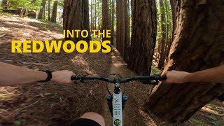
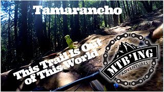
This is the first trail most people run into after climbing up Alchemist. This is assuming you came into the camp via Iron Springs Road. It is a trail with equal ups and downs not a lot of climbing but not a lot of descending. Nothing overly technical, a few tree roots and ruts but most with multiple lines. It is all singletrack and very well maintained. Remember this is a trail within Camp Tamarancho and a fee is associated with riding in the camp, mind you it is a small fee that is well worth the experience. Easily purchased at sunshine bikes in Fairfax or online.

Local Trail Association
Traditionally Indigenous Territory

Recent Activity on Trail

Past Week
  • 10 rides
  • 15 miles average
6 Months
  • 227 rides
  • 15 miles avg distance
All
  • 893 rides
  • Last: Jun 19, 2026
c1c2c3c4
January
February
March
April
May
June
July
August
September
October
November
December
Status:
on Apr 15, 2026
Variable
Avg: 3.88 (19 votes)
Your vote: 0

view (7,641)
close
3D
Trail Conditions
  • Unknown
  • Snow Groomed
  • Snow Packed
  • Snow Covered
  • Snow Cover Partial
  • Freeze/thaw Cycle
  • Icy
  • Prevalent Mud
  • Wet
  • Variable
  • Ideal
  • Dry
  • Very Dry
Trail Flow (Ridden Direction)
Trailforks scans users ridelogs to determine the most popular direction each trail is ridden. A good flowing trail network will have most trails flowing in a single direction according to their intension.
The colour categories are based on what percentage of riders are riding a trail in its intended direction.
  • > 96%
  • > 90%
  • > 80%
  • > 70%
  • > 50%
  • < 50%
  • bi-directional trail
  • no data
Trail Last Ridden
Trailforks scans ridelogs to determine the last time a trail was ridden.
  • < 2 days
  • < 1 week
  • < 2 weeks
  • < 1 month
  • < 6 months
  • > 6 months
Trail Ridden Direction
The intended direction a trail should be ridden.
  • Downhill Only
  • Downhill Primary
  • Both Directions
  • Uphill Primary
  • Uphill Only
  • One Direction
Contribute Details
Colors indicate trail is missing specified detail.
  • Description
  • Photos
  • Description & Photos
  • Videos
Trail Popularity ?
Trailforks scans ridelogs to determine which trails are ridden the most in the last 9 months. Trails are compared with nearby trails in the same city region with a possible 25 colour shades. Think of this as a heatmap, more rides = more kinetic energy = warmer colors.
  • most popular
  • popular
  • less popular
  • not popular
ATV/ORV/OHV Filter
Max Vehicle Width
inches
US Cell Coverage
Legend
cell carrier legend

Radar Time
Activity Recordings
Trailforks uses anonymized public activity data. ?
Activity Recordings
Trailforks uses anonymized public activity data. ?
Personal Heatmap
Activity Types
all / none
Options
2
Date range month
Winter Trails
Warning A routing network for winter maps does not exist. Selecting trails using the winter trails layer has been disabled.
Missing Trails
Most Popular
Least Popular
Trails are colored based on popularity. The more popular a trail is, the more red. Less popular trails trend towards green.
Jump Magnitude Heatmap
Heatmap of where riders jump on trails. Zoom in to see individual jumps, click circles to view jump details.
BC Backroad Status

Service Road Atlas is a free to use, community-driven service for viewing and creating reports on the numerous back-country service roads around B.C. and Alberta.

map legend
Slope Aspect
Direction the slope faces
Flat N NE E SE S SW W NW
Trails Deemphasized
Trails are shown in grey.
disable
Only show trails with no bike usage.
Enable
Suggested Layers
Based on selected activity type

    Save the current map location and zoom level as your default home location whenever this page is loaded.

    Save
        Directions to goldman-trail trailhead (37.997020, -122.612490)

        Photos

        3 more »
        530 |
        Mar 4, 2019 @ 11:34am
        Mar 4, 2019
        370 |
        Feb 16, 2015 @ 9:10pm
        Feb 16, 2015
        55 |
        Jan 11, 2025 @ 8:18pm
        Jan 11, 2025

        Videos

        3 more »
        Camp Tamarancho Loop, Fairfax, California
        6:00 | 148 | May 30, 2024 , Fairfax
        Broken rear derailleur at Tamarancho in 4k
        14:03 | 179 | Oct 6, 2020 , Fairfax
        youtuber Tamarancho 2018 (Fairfax,CA)  Mountain Biking
        16:22 | 493 | Sep 18, 2018 , Fairfax

        Routes with this trail

        5.0 14 miles 2,406 ft 7
        Tamarancho Ride from Fairfax. Maiden Voyage
        3.5 7 miles 1,254 ft 10 Loop
        Great loop around Tamarancho Trail system!
        3.0 10 miles 1,748 ft 11
        To tam loop via alchimist

        Trail Products

        2 Reviews & Comments


        We hope you've been enjoying Trailforks!

        Create a FREE account to view trail comments and much more.

        • By TheBikeNerdTF Pro NWTA & contributors
        • #20427 - 3,169 views

        Frequently Asked Questions About Goldman Trail

        Where is Goldman Trail located?
        Goldman Trail is located in Tamarancho, Fairfax, California, United States. It is part of the Tamarancho trail network. The trailhead is located at coordinates 37.99702, -122.61249.
        How hard is Goldman Trail?
        Goldman Trail is rated as Blue difficulty. The physical rating is Moderate. The climb difficulty is rated Blue.
        What is the elevation gain for Goldman Trail?
        Goldman Trail has 188 ft of elevation gain. The trail has 235 ft of elevation descent. The elevation ranges from 646 ft to 775 ft.
        Is Goldman Trail a point to point trail?
        Goldman Trail is not a point to point trail. The direction is Both Directions. The trail type is singletrack.

        Hit the Trail

        Open in App

        Get this trail on your phone instantly.
        open trail in app

        Download Trail

        Save to wishlist, Garmin & download.
        save the trail

        Find Related Routes

        Find routes and users activities that include this trail.
        find routes for this trail

        You must enter a description before submitting.