more stats
1.1 miles
Distance
51 ft
Climb
-1,457 ft
Descent
00:20:37
Avg time
-1,406 ft
Altitude change
3,484 ft
Altitude min
4,942 ft
Altitude max
4,890 ft
Altitude start
3,484 ft
Altitude end
-23.2%
Grade
-121.7%
Grade max
16.1%
Grade min
896 ft
Distance climb
5,135 ft
Distance down
26 ft
Distance flat
00:20:37
Avg time

Goldmember Details

  • Activities
    • Mountain Bike
    • E-Bike
  • Riding Area
    Giveout and Gold Creek
    Nelson, British Columbia
  • Difficulty Rating
  • Local Popularity
    60 in Mountain Biking [+]
    • 35 in E-Biking
  • Global Ranking
    #104656 in Mountain Biking [+]
    • #99293 in E-Biking
  • Trail Type
    Singletrack
  • Bike Type
    DH
  • Direction
    Downhill Only[+]
    Popular Direction Shown
    • Downhill Only for E-Biking
  • Dogs Allowed
    Yes
  • eBike Allowed
    Yes up to Class 1
  • TTFs on Trail
    Drop

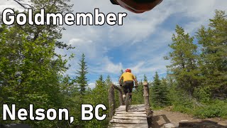
Do a very short double-track climb and look for the start of the trail
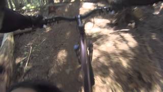
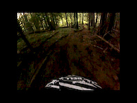
on the right near the top out. Goldmember offers up plenty of steeps,
stunts, and airs, with some harsher technical lines.

On the lower section, keep right to stay on Goldmember at the SFD junction.

Access Info

Giveout Creek FSR

Trail Supporters
Local Trail Association

Recent Activity on Trail

Past Week
  • 0 rides
  •  
6 Months
  • 2 rides
  • 4 miles avg distance
All
  • 26 rides
  • Last: Jun 19, 2026
c1c2c3c4
January
February
March
April
May
June
July
August
September
October
November
December
update trails status or condition

Goldmember Trail Reports

statusdatedescription
Jun 1, 2026 @ 7:57am (America/Vancouver)
Jun 1, 2026
2 trees down right near the bottom about 50m up from road. Needs a chainsaw. This was around 1pm May 31 so might have been cleared by now.
May 5, 2026 @ 10:03pm (America/Vancouver)
May 5, 2026
Almost full snow till about a third way down the trail, plus a few trees down.
May 7, 2025 @ 6:10pm
May 7, 2025
Cleared all trees from road cross down
May 2, 2025 @ 8:43pm
May 2, 2025
About 1/3 the way down from the road there are 2 seprate larger trees down not too far apart. (no photos) . Could probably get with a big boy or...
Jul 18, 2024 @ 11:49am
Jul 18, 2024
Perfect sketchball conditions.
more » 2 social media mentions
Status:
on Jun 1, 2026
Avg: 3.99 (3 votes)
Your vote: 0

view (218)
close
3D
Trail Conditions
  • Unknown
  • Snow Groomed
  • Snow Packed
  • Snow Covered
  • Snow Cover Partial
  • Freeze/thaw Cycle
  • Icy
  • Prevalent Mud
  • Wet
  • Variable
  • Ideal
  • Dry
  • Very Dry
Trail Flow (Ridden Direction)
Trailforks scans users ridelogs to determine the most popular direction each trail is ridden. A good flowing trail network will have most trails flowing in a single direction according to their intension.
The colour categories are based on what percentage of riders are riding a trail in its intended direction.
  • > 96%
  • > 90%
  • > 80%
  • > 70%
  • > 50%
  • < 50%
  • bi-directional trail
  • no data
Trail Last Ridden
Trailforks scans ridelogs to determine the last time a trail was ridden.
  • < 2 days
  • < 1 week
  • < 2 weeks
  • < 1 month
  • < 6 months
  • > 6 months
Trail Ridden Direction
The intended direction a trail should be ridden.
  • Downhill Only
  • Downhill Primary
  • Both Directions
  • Uphill Primary
  • Uphill Only
  • One Direction
Contribute Details
Colors indicate trail is missing specified detail.
  • Description
  • Photos
  • Description & Photos
  • Videos
Trail Popularity ?
Trailforks scans ridelogs to determine which trails are ridden the most in the last 9 months. Trails are compared with nearby trails in the same city region with a possible 25 colour shades. Think of this as a heatmap, more rides = more kinetic energy = warmer colors.
  • most popular
  • popular
  • less popular
  • not popular
ATV/ORV/OHV Filter
Max Vehicle Width
inches
US Cell Coverage
Legend
cell carrier legend

Radar Time
Activity Recordings
Trailforks uses anonymized public activity data. ?
Activity Recordings
Trailforks uses anonymized public activity data. ?
Personal Heatmap
Activity Types
all / none
Options
2
Date range month
Winter Trails
Warning A routing network for winter maps does not exist. Selecting trails using the winter trails layer has been disabled.
Missing Trails
Most Popular
Least Popular
Trails are colored based on popularity. The more popular a trail is, the more red. Less popular trails trend towards green.
Jump Magnitude Heatmap
Heatmap of where riders jump on trails. Zoom in to see individual jumps, click circles to view jump details.
BC Backroad Status

Service Road Atlas is a free to use, community-driven service for viewing and creating reports on the numerous back-country service roads around B.C. and Alberta.

map legend
Slope Aspect
Direction the slope faces
Flat N NE E SE S SW W NW
Trails Deemphasized
Trails are shown in grey.
disable
Only show trails with no bike usage.
Enable
Suggested Layers
Based on selected activity type

    Save the current map location and zoom level as your default home location whenever this page is loaded.

    Save
        Directions to goldmember trailhead (49.437300, -117.283200)

        Photos

        13 more »
        693 |
        Jul 3, 2015 @ 2:12pm
        Jul 3, 2015
        52 |
        Jul 2, 2024 @ 4:00pm
        Jul 2, 2024
        62 |
        Jul 2, 2024 @ 3:33pm
        Jul 2, 2024
        333 |
        Jul 19, 2010 @ 5:32am
        Jul 19, 2010

        Videos

        3 more »
        youtuber Goldmember - Nelson, BC
        10:09 | 559 | Jul 20, 2023 , Nelson
        youtuber Mountain Biking: Gold Member, Nelson, BC
        3:56 | 872 | Jan 27, 2020 , Nelson
        Goldmember
        12:18 | 649 | Jul 3, 2013 , Nelson

        Trail Products

        Reviews / Comments

        No reviews yet, be the first to write a review or ask a question.
        Use trail reports to comment on trail conditions.


        We hope you've been enjoying Trailforks!

        Create a FREE account to view trail comments and much more.

        • By canadakaTF Pro Trailforks & contributors
        • #1996 - 5,138 views

        Frequently Asked Questions About Goldmember

        Where is Goldmember located?
        Goldmember is located in Giveout and Gold Creek, Nelson, British Columbia, Canada. It is part of the Giveout and Gold Creek trail network. The trailhead is located at coordinates 49.4373, -117.2832.
        How hard is Goldmember?
        Goldmember is rated as Double Black Diamond difficulty. The average grade is 23.2%.
        What is the elevation gain for Goldmember?
        Goldmember has 51 ft of elevation gain. The trail has 1,457 ft of elevation descent. The elevation ranges from 3,484 ft to 4,942 ft.
        Is Goldmember a point to point trail?
        Yes, Goldmember is a point to point trail. The direction is Downhill Only. The trail type is singletrack.

        Hit the Trail

        Open in App

        Get this trail on your phone instantly.
        open trail in app

        Download Trail

        Save to wishlist, Garmin & download.
        save the trail

        Find Related Routes

        Find routes and users activities that include this trail.
        find routes for this trail

        You must enter a description before submitting.