more stats
2,835 ft
Distance
2 ft
Climb
-2 ft
Descent
00:04:49
Avg time
753 ft
Altitude min
756 ft
Altitude max
756 ft
Altitude start
755 ft
Altitude end
-1.9%
Grade max
1%
Grade min
174 ft
Distance climb
125 ft
Distance down
1,670 ft
Distance flat
00:04:49
Avg time

Goose it Details

  • Activities
    • Mountain Bike
    • Winter Fat Bike
    • Hike
    • Trail Running
  • Riding Area
    Bison Butte Recreational Trails
    Winnipeg, Manitoba
  • Difficulty Rating
  • Local Popularity
    95 in Mountain Biking [+]
    • 60 in Trail Running
    • 5 in Hiking
  • Global Ranking
    #60182 in Mountain Biking [+]
    • #94308 in Trail Running
    • #306115 in Hiking
  • Trail Type
    Singletrack
  • Bike Type
    AM, XC, Fat
  • Direction
    One Direction
    Popular Direction Shown
  • Climb Difficulty
    Blue
  • Physical Rating
    Moderate
  • Dogs Allowed
    Yes
  • TTFs on Trail
    Berm, Bridge, Drop, Jump

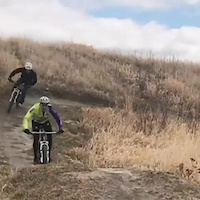
This line shows the easier descent option without the mandatory drops. Very flowy high speed berm section to start, table top jumps included. Continues on to following the lake contour with undulating single track, then doubles back and finishes with a difficult short climb up to the top of the hill. The final climb has two line options; pretty hard, and very hard. You'll know it when you see it.

Mind the Geese :-)

Disclaimer

Helmets mandatory. Riders assume all risks.

Local Trail Association

Recent Activity on Trail

Past Week
  • 2 rides
  • 15 miles average
6 Months
  • 22 rides
  • 12 miles avg distance
All
  • 391 rides
  • Last: Jun 22, 2026
c1c2c3c4
January
February
March
April
May
June
July
August
September
October
November
December
Status:
on Aug 28, 2025
Ideal
Avg: 3.98 (1 votes)
Your vote: 0

view (4,203)
close
3D
Trail Conditions
  • Unknown
  • Snow Groomed
  • Snow Packed
  • Snow Covered
  • Snow Cover Partial
  • Freeze/thaw Cycle
  • Icy
  • Prevalent Mud
  • Wet
  • Variable
  • Ideal
  • Dry
  • Very Dry
Trail Flow (Ridden Direction)
Trailforks scans users ridelogs to determine the most popular direction each trail is ridden. A good flowing trail network will have most trails flowing in a single direction according to their intension.
The colour categories are based on what percentage of riders are riding a trail in its intended direction.
  • > 96%
  • > 90%
  • > 80%
  • > 70%
  • > 50%
  • < 50%
  • bi-directional trail
  • no data
Trail Last Ridden
Trailforks scans ridelogs to determine the last time a trail was ridden.
  • < 2 days
  • < 1 week
  • < 2 weeks
  • < 1 month
  • < 6 months
  • > 6 months
Trail Ridden Direction
The intended direction a trail should be ridden.
  • Downhill Only
  • Downhill Primary
  • Both Directions
  • Uphill Primary
  • Uphill Only
  • One Direction
Contribute Details
Colors indicate trail is missing specified detail.
  • Description
  • Photos
  • Description & Photos
  • Videos
Trail Popularity ?
Trailforks scans ridelogs to determine which trails are ridden the most in the last 9 months. Trails are compared with nearby trails in the same city region with a possible 25 colour shades. Think of this as a heatmap, more rides = more kinetic energy = warmer colors.
  • most popular
  • popular
  • less popular
  • not popular
ATV/ORV/OHV Filter
Max Vehicle Width
inches
US Cell Coverage
Legend
cell carrier legend

Radar Time
Activity Recordings
Trailforks uses anonymized public activity data. ?
Activity Recordings
Trailforks uses anonymized public activity data. ?
Personal Heatmap
Activity Types
all / none
Options
2
Date range month
Winter Trails
Warning A routing network for winter maps does not exist. Selecting trails using the winter trails layer has been disabled.
Missing Trails
Most Popular
Least Popular
Trails are colored based on popularity. The more popular a trail is, the more red. Less popular trails trend towards green.
Jump Magnitude Heatmap
Heatmap of where riders jump on trails. Zoom in to see individual jumps, click circles to view jump details.
BC Backroad Status

Service Road Atlas is a free to use, community-driven service for viewing and creating reports on the numerous back-country service roads around B.C. and Alberta.

map legend
Slope Aspect
Direction the slope faces
Flat N NE E SE S SW W NW
Trails Deemphasized
Trails are shown in grey.
disable
Only show trails with no bike usage.
Enable
Suggested Layers
Based on selected activity type

    Save the current map location and zoom level as your default home location whenever this page is loaded.

    Save
        Directions to goose-it trailhead (49.833850, -97.218020)

        Photos

        2 more »
        299 |
        Jun 4, 2020 @ 11:08pm
        Jun 4, 2020
        69 |
        Jul 24, 2022 @ 6:15pm
        Jul 24, 2022

        Videos

        1 more »
        Table Tops and rollers
        0:10 | 628 | Apr 28, 2018 , Winnipeg

        Reviews / Comments

        No reviews yet, be the first to write a review or ask a question.
        Use trail reports to comment on trail conditions.


        We hope you've been enjoying Trailforks!

        Create a FREE account to view trail comments and much more.

        • By crislabossiereTF Pro SWTA MTB MB & contributors
        • #126131 - 1,956 views

        Frequently Asked Questions About Goose it

        Where is Goose it located?
        Goose it is located in Bison Butte Recreational Trails, Winnipeg, Manitoba, Canada. It is part of the Bison Butte Recreational Trails trail network. The trailhead is located at coordinates 49.83385, -97.21802.
        How hard is Goose it?
        Goose it is rated as Blue difficulty. The physical rating is Moderate. The climb difficulty is rated Blue.
        What is the elevation gain for Goose it?
        Goose it has 2 ft of elevation gain. The trail has 2 ft of elevation descent. The elevation ranges from 753 ft to 756 ft.
        Is Goose it a point to point trail?
        Yes, Goose it is a point to point trail. The direction is One Direction. The trail type is singletrack.

        Hit the Trail

        Open in App

        Get this trail on your phone instantly.
        open trail in app

        Download Trail

        Save to wishlist, Garmin & download.
        save the trail

        Find Related Routes

        Find routes and users activities that include this trail.
        find routes for this trail

        You must enter a description before submitting.