more stats
1.4 miles
Distance
76 ft
Climb
-1,077 ft
Descent
00:31:59
Avg time
-1,001 ft
Altitude change
314 ft
Altitude min
1,315 ft
Altitude max
1,315 ft
Altitude start
314 ft
Altitude end
-13.525%
Grade
-42.301%
Grade max
28.536%
Grade min
679 ft
Distance climb
1 mile
Distance down
187 ft
Distance flat
00:31:59
Avg time

Gorilla Details

  • Activities
    • Mountain Bike
    • Hike
    • Trail Running
  • Riding Area
    Hope
    , British Columbia
  • Difficulty Rating
  • Local Popularity
    5 in Mountain Biking [+]
    • 5 in Trail Running
    • 5 in Hiking
  • Global Ranking
    #123712 in Mountain Biking [+]
    • #129273 in Trail Running
    • #122272 in Hiking
  • Trail Type
    Singletrack
  • Bike Type
    DH, AM
  • Direction
    Downhill Primary
    Popular Direction Shown
  • Climb Difficulty
    Black Diamond
  • Physical Rating
    Moderate
  • Trail Visibility
    Always easy to follow
  • Dogs Allowed
    Yes
  • TTFs on Trail
    Ladder Bridge

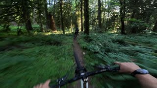
Hike to the top using the Gorilla climbing trail. Then rip down the mountain all the way to Kawkwa Lake. Trail is fairly new with jump and drops and some steep and technical areas. At a point branch off and try and newly added Macho Mango. Two different routes on one great mountain. Very scenic and green throughout the hole trail. Know your limits as a rider and if unclear on the feature ahead. Check it before you wreck it. Enjoy riders!!

Local Trail Association

Recent Activity on Trail

Past Week
  • 0 rides
  •  
6 Months
  • 0 rides
  •  
All
  • 7 rides
  • Last: Mar 16, 2024
c1c2c3c4
January
February
March
April
May
June
July
August
September
October
November
December
update trails status or condition

Gorilla Trail Reports

statusdatedescription
Aug 12, 2025 @ 11:56am
Aug 12, 2025
Didn t find the middle section. I think it disappeared under vegetation. I took macho mambo instead which is really good and seem to be the...
Mar 16, 2024 @ 1:48pm
Mar 16, 2024
Good shape, nothing down, top section seems to have been raked. One steeper spot just before you cross the climb/hike trail has alot of water...
Sep 30, 2023 @ 6:55pm
Sep 30, 2023
took turn off to macho mango ( amazing flow build and some steep sections).
May 29, 2020 @ 11:55am
May 29, 2020
Take the “macho mango” bypass, middle is a riverbed and your hands will thank you
Jul 6, 2019 @ 2:15pm
Jul 6, 2019
reporter Really feels like 3 separate trails. Top is newer and loamy, great conditions. Middle section is rather overgrown at the moment. Bottom section...
more »
Status:
on Aug 12, 2025
Ideal
Avg: 4.33 (6 votes)
Your vote: 0

view (15)
close
3D
Trail Conditions
  • Unknown
  • Snow Groomed
  • Snow Packed
  • Snow Covered
  • Snow Cover Partial
  • Freeze/thaw Cycle
  • Icy
  • Prevalent Mud
  • Wet
  • Variable
  • Ideal
  • Dry
  • Very Dry
Trail Flow (Ridden Direction)
Trailforks scans users ridelogs to determine the most popular direction each trail is ridden. A good flowing trail network will have most trails flowing in a single direction according to their intension.
The colour categories are based on what percentage of riders are riding a trail in its intended direction.
  • > 96%
  • > 90%
  • > 80%
  • > 70%
  • > 50%
  • < 50%
  • bi-directional trail
  • no data
Trail Last Ridden
Trailforks scans ridelogs to determine the last time a trail was ridden.
  • < 2 days
  • < 1 week
  • < 2 weeks
  • < 1 month
  • < 6 months
  • > 6 months
Trail Ridden Direction
The intended direction a trail should be ridden.
  • Downhill Only
  • Downhill Primary
  • Both Directions
  • Uphill Primary
  • Uphill Only
  • One Direction
Contribute Details
Colors indicate trail is missing specified detail.
  • Description
  • Photos
  • Description & Photos
  • Videos
Trail Popularity ?
Trailforks scans ridelogs to determine which trails are ridden the most in the last 9 months. Trails are compared with nearby trails in the same city region with a possible 25 colour shades. Think of this as a heatmap, more rides = more kinetic energy = warmer colors.
  • most popular
  • popular
  • less popular
  • not popular
ATV/ORV/OHV Filter
Max Vehicle Width
inches
US Cell Coverage
Legend
cell carrier legend

Radar Time
Activity Recordings
Trailforks uses anonymized public activity data. ?
Activity Recordings
Trailforks uses anonymized public activity data. ?
Personal Heatmap
Activity Types
all / none
Options
2
Date range month
Winter Trails
Warning A routing network for winter maps does not exist. Selecting trails using the winter trails layer has been disabled.
Missing Trails
Most Popular
Least Popular
Trails are colored based on popularity. The more popular a trail is, the more red. Less popular trails trend towards green.
Jump Magnitude Heatmap
Heatmap of where riders jump on trails. Zoom in to see individual jumps, click circles to view jump details.
BC Backroad Status

Service Road Atlas is a free to use, community-driven service for viewing and creating reports on the numerous back-country service roads around B.C. and Alberta.

map legend
Slope Aspect
Direction the slope faces
Flat N NE E SE S SW W NW
Trails Deemphasized
Trails are shown in grey.
disable
Only show trails with no bike usage.
Enable
Suggested Layers
Based on selected activity type

    Save the current map location and zoom level as your default home location whenever this page is loaded.

    Save
        Directions to gorilla-165408 trailhead (49.387900, -121.359360)

        Photos

        37 more »
        181 |
        Jul 19, 2019 @ 2:29pm
        Jul 19, 2019
        221 |
        Jun 13, 2019 @ 7:38pm
        Jun 13, 2019
        132 |
        Nov 14, 2020 @ 8:42am
        Nov 14, 2020
        116 |
        Nov 14, 2020 @ 8:42am
        Nov 14, 2020

        Videos

        1 more »
        Gorilla trail
        7:12 | 165 | Jul 21, 2025 , Hope

        Trail Products

        10 Reviews & Comments


        We hope you've been enjoying Trailforks!

        Create a FREE account to view trail comments and much more.

        • By sheriffteasel FVMBA - Hope & contributors
        • #165408 - 3,285 views

        Frequently Asked Questions About Gorilla

        Where is Gorilla located?
        Gorilla is located in Hope, British Columbia, Canada. It is part of the Hope trail network. The trailhead is located at coordinates 49.3879, -121.35936.
        How hard is Gorilla?
        Gorilla is rated as Black Diamond difficulty. The physical rating is Moderate. The average grade is 13.525%. The climb difficulty is rated Black Diamond.
        What is the elevation gain for Gorilla?
        Gorilla has 76 ft of elevation gain. The trail has 1,077 ft of elevation descent. The elevation ranges from 314 ft to 1,315 ft.
        Is Gorilla a point to point trail?
        Gorilla is not a point to point trail. The direction is Downhill Primary. The trail type is singletrack.

        Hit the Trail

        Open in App

        Get this trail on your phone instantly.
        open trail in app

        Download Trail

        Save to wishlist, Garmin & download.
        save the trail

        Find Related Routes

        Find routes and users activities that include this trail.
        find routes for this trail

        You must enter a description before submitting.