more stats
1,093 ft
Distance
-165 ft
Descent
00:09:29
Avg time
-165 ft
Altitude change
585 ft
Altitude min
752 ft
Altitude max
751 ft
Altitude start
584 ft
Altitude end
-15.2%
Grade
-39.9%
Grade max
-1%
Grade min
23 ft
Distance climb
1,030 ft
Distance down
39 ft
Distance flat
00:09:29
Avg time

Gouranga Details

  • Activities
    • Mountain Bike
    • E-Bike
    • Observed Trials
  • Riding Area
    Alice Lake & Highlands
    Squamish, British Columbia
  • Difficulty Rating
  • Voted Difficulty
    Double Black Diamond (4 votes)
  • Local Popularity
    75 in Mountain Biking [+]
    • 80 in E-Biking
    • 5 in Observed Trials
  • Global Ranking
    #34586 in Mountain Biking [+]
    • #35911 in E-Biking
    • #189 in Observed Trials
  • Trail Type
    Singletrack
  • Bike Type
    DH, AM
  • Direction
    Downhill Only
    Popular Direction Shown
  • Dogs Allowed
    Yes
  • eBike Allowed
    Yes up to Class 1
  • TTFs on Trail
    Drop, Rock Face

It was an abandoned forgotten, left to rot trail in 2009.
D. Joseph decided it was worth reclaiming. Boggles the mind to think it was left to die.
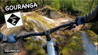
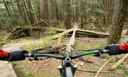
Fun steep technical trail, with options galore. Also some fun slabs.

Of note is the finale slab at the end on the right - which used to be ridden with v brakes.
One of the best in Squamish.

Local Trail Association
Traditionally Indigenous Territory

Recent Activity on Trail

Past Week
  • 3 rides
  • 15 miles average
6 Months
  • 44 rides
  • 9 miles avg distance
All
  • 756 rides
  • Last: Jun 13, 2026
c1c2c3c4
January
February
March
April
May
June
July
August
September
October
November
December
Status:
on Jun 6, 2026
Ideal
Avg: 4.42 (33 votes)
Your vote: 0

view (4,901)
close
3D
Trail Conditions
  • Unknown
  • Snow Groomed
  • Snow Packed
  • Snow Covered
  • Snow Cover Partial
  • Freeze/thaw Cycle
  • Icy
  • Prevalent Mud
  • Wet
  • Variable
  • Ideal
  • Dry
  • Very Dry
Trail Flow (Ridden Direction)
Trailforks scans users ridelogs to determine the most popular direction each trail is ridden. A good flowing trail network will have most trails flowing in a single direction according to their intension.
The colour categories are based on what percentage of riders are riding a trail in its intended direction.
  • > 96%
  • > 90%
  • > 80%
  • > 70%
  • > 50%
  • < 50%
  • bi-directional trail
  • no data
Trail Last Ridden
Trailforks scans ridelogs to determine the last time a trail was ridden.
  • < 2 days
  • < 1 week
  • < 2 weeks
  • < 1 month
  • < 6 months
  • > 6 months
Trail Ridden Direction
The intended direction a trail should be ridden.
  • Downhill Only
  • Downhill Primary
  • Both Directions
  • Uphill Primary
  • Uphill Only
  • One Direction
Contribute Details
Colors indicate trail is missing specified detail.
  • Description
  • Photos
  • Description & Photos
  • Videos
Trail Popularity ?
Trailforks scans ridelogs to determine which trails are ridden the most in the last 9 months. Trails are compared with nearby trails in the same city region with a possible 25 colour shades. Think of this as a heatmap, more rides = more kinetic energy = warmer colors.
  • most popular
  • popular
  • less popular
  • not popular
ATV/ORV/OHV Filter
Max Vehicle Width
inches
US Cell Coverage
Legend
cell carrier legend

Radar Time
Activity Recordings
Trailforks uses anonymized public activity data. ?
Activity Recordings
Trailforks uses anonymized public activity data. ?
Personal Heatmap
Activity Types
all / none
Options
2
Date range month
Winter Trails
Warning A routing network for winter maps does not exist. Selecting trails using the winter trails layer has been disabled.
Missing Trails
Most Popular
Least Popular
Trails are colored based on popularity. The more popular a trail is, the more red. Less popular trails trend towards green.
Jump Magnitude Heatmap
Heatmap of where riders jump on trails. Zoom in to see individual jumps, click circles to view jump details.
BC Backroad Status

Service Road Atlas is a free to use, community-driven service for viewing and creating reports on the numerous back-country service roads around B.C. and Alberta.

map legend
Slope Aspect
Direction the slope faces
Flat N NE E SE S SW W NW
Trails Deemphasized
Trails are shown in grey.
disable
Only show trails with no bike usage.
Enable
Suggested Layers
Based on selected activity type

    Save the current map location and zoom level as your default home location whenever this page is loaded.

    Save
        Directions to gouranga trailhead (49.754990, -123.112600)

        Photos

        33 more »
        422 |
        Jul 1, 2022 @ 9:39am
        Jul 1, 2022
        947 |
        Apr 6, 2022 @ 11:20pm
        Apr 6, 2022
        286 |
        May 29, 2021 @ 9:39am
        May 29, 2021
        202 |
        May 29, 2021 @ 9:39am
        May 29, 2021

        Videos

        22 more »
        youtuber Trail Preview | Sourkraut , Chossy's slabs,...
        12:49 | 2735 | Aug 22, 2019 , Squamish
        youtuber Riding New Trails at 57?!  Squamish BC, ...
        7:35 | 791 | Aug 1, 2019 , Squamish
        youtuber Gouranga in Squamish BC   The easy route in 4K
        4:03 | 1753 | Apr 30, 2018 , Squamish
        youtuber GOURANGA | Double black trail | Squamish -...
        2:10 | 195 | Dec 10, 2023 , Squamish

        Articles

        Video: Remy Metailler Takes Steve Vanderhoek for a Gnarly Ride
        Apr 7, 2022 from pinkbike.com
        Remy helps Steve progress to the gnarliest side hits on Gouranga in Squamish.
        Video: Remy Metailler Rides Squamish's Iconic Treasure Trail
        Apr 22, 2020 from pinkbike.com
        Widely considered Squamish's most technical trail.

        Trail Lists

        Routes with this trail

        3.0 11 miles 2,094 ft 37 Loop
        The toughest trails in Squamish, compiled. Try not to crash.
        6 miles 1,349 ft 11
        > > >
        23 miles 4,962 ft 34
        Best Double Blacks of Squamish

        3 Reviews & Comments


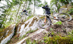
        We hope you've been enjoying Trailforks!

        Create a FREE account to view trail comments and much more.

        • By davereidTF Pro & contributors
        • #921 - 19,025 views

        Frequently Asked Questions About Gouranga

        Where is Gouranga located?
        Gouranga is located in Alice Lake & Highlands, Squamish, British Columbia, Canada. It is part of the Alice Lake & Highlands trail network. The trailhead is located at coordinates 49.75499, -123.1126.
        How hard is Gouranga?
        Gouranga is rated as Black Diamond difficulty. The average grade is 15.2%.
        What is the elevation gain for Gouranga?
        The trail has 165 ft of elevation descent. The elevation ranges from 585 ft to 752 ft.
        Is Gouranga a point to point trail?
        Yes, Gouranga is a point to point trail. The direction is Downhill Only. The trail type is singletrack.

        Hit the Trail

        Open in App

        Get this trail on your phone instantly.
        open trail in app

        Download Trail

        Save to wishlist, Garmin & download.
        save the trail

        Find Related Routes

        Find routes and users activities that include this trail.
        find routes for this trail

        You must enter a description before submitting.