more stats
2.3 miles
Distance
465 ft
Climb
-213 ft
Descent
00:25:26
Avg time
252 ft
Altitude change
4,240 ft
Altitude min
4,652 ft
Altitude max
4,243 ft
Altitude start
4,495 ft
Altitude end
2.1%
Grade
-32.2%
Grade max
32.4%
Grade min
1 mile
Distance climb
2,329 ft
Distance down
3,766 ft
Distance flat
00:25:26
Avg time

Grand Central Details

  • Activities
    • Mountain Bike
    • Hike
    • Trail Running
  • Riding Area
    Soldier Wash
    Sedona, Arizona
  • Ref Number
    #661
  • Difficulty Rating
  • Voted Difficulty
    Black Diamond (5 votes)
  • Local Popularity
    85 in Mountain Biking [+]
    • 55 in Trail Running
    • 40 in Hiking
  • Global Ranking
    #2343 in Mountain Biking [+]
    • #82260 in Trail Running
    • #107094 in Hiking
  • Hiking SAC Scale
    T1 Hiking
  • Trail Type
    Singletrack
  • Direction
    Both Directions
    Popular Direction Shown
  • Dogs Allowed
    Yes
  • eBike Allowed

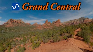
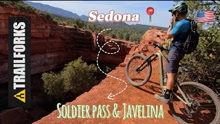
Beginner 20%, intermediate 50 % and advanced 30%, 2.3 mile MTB trail which is a bi-directional singletrack The trai is very diverse in its character. It has several long climbs and descents in the north section and in the middle it rides through a large gravel wash section with optional sections on single track for those riders who don't like wash riding that Sedona is famous for. In the southern section it has less climbing and is in and out of the wash more than what you experience in the middle.

If you wanted to ride the middle of Soldier Wash in the most downhill direction from the Sinkhole you would not ride Grand Central the whole way. You would ride Jordan to Ant Hill (clockwise) to Grand Central to Hwy. 89 A.

Section of Grand Central can be used to make a number of fun loops in the Soldier Wash area.

Trail Supporters

  • USFS
    Land Manager
Local Trail Association

Recent Activity on Trail

Past Week
  • 0 rides
  •  
6 Months
  • 96 rides
  • 11 miles avg distance
All
  • 915 rides
  • Last: Jun 13, 2026
c1c2c3c4
January
February
March
April
May
June
July
August
September
October
November
December
update trails status or condition

Grand Central Trail Reports

statusdatedescription
Mar 29, 2025 @ 10:06am
Mar 29, 2025
Hero dirt.
Oct 7, 2024 @ 11:27am
Oct 7, 2024
Jul 2, 2024 @ 11:56am
Jul 2, 2024
Tree was down in between manzanita jct and coyote jct(removed). Small debris on trail. Caution, rest of tree looked like it was ready to tip over...
Jul 1, 2024 @ 6:51am
Jul 1, 2024
Apr 17, 2024 @ 3:06pm
Apr 17, 2024
more »
Status:
on Mar 29, 2025
Ideal
Avg: 4.35 (45 votes)
Your vote: 0

view (4,622)
close
3D
Trail Conditions
  • Unknown
  • Snow Groomed
  • Snow Packed
  • Snow Covered
  • Snow Cover Partial
  • Freeze/thaw Cycle
  • Icy
  • Prevalent Mud
  • Wet
  • Variable
  • Ideal
  • Dry
  • Very Dry
Trail Flow (Ridden Direction)
Trailforks scans users ridelogs to determine the most popular direction each trail is ridden. A good flowing trail network will have most trails flowing in a single direction according to their intension.
The colour categories are based on what percentage of riders are riding a trail in its intended direction.
  • > 96%
  • > 90%
  • > 80%
  • > 70%
  • > 50%
  • < 50%
  • bi-directional trail
  • no data
Trail Last Ridden
Trailforks scans ridelogs to determine the last time a trail was ridden.
  • < 2 days
  • < 1 week
  • < 2 weeks
  • < 1 month
  • < 6 months
  • > 6 months
Trail Ridden Direction
The intended direction a trail should be ridden.
  • Downhill Only
  • Downhill Primary
  • Both Directions
  • Uphill Primary
  • Uphill Only
  • One Direction
Contribute Details
Colors indicate trail is missing specified detail.
  • Description
  • Photos
  • Description & Photos
  • Videos
Trail Popularity ?
Trailforks scans ridelogs to determine which trails are ridden the most in the last 9 months. Trails are compared with nearby trails in the same city region with a possible 25 colour shades. Think of this as a heatmap, more rides = more kinetic energy = warmer colors.
  • most popular
  • popular
  • less popular
  • not popular
ATV/ORV/OHV Filter
Max Vehicle Width
inches
US Cell Coverage
Legend
cell carrier legend

Radar Time
Activity Recordings
Trailforks uses anonymized public activity data. ?
Activity Recordings
Trailforks uses anonymized public activity data. ?
Personal Heatmap
Activity Types
all / none
Options
2
Date range month
Winter Trails
Warning A routing network for winter maps does not exist. Selecting trails using the winter trails layer has been disabled.
Missing Trails
Most Popular
Least Popular
Trails are colored based on popularity. The more popular a trail is, the more red. Less popular trails trend towards green.
Jump Magnitude Heatmap
Heatmap of where riders jump on trails. Zoom in to see individual jumps, click circles to view jump details.
BC Backroad Status

Service Road Atlas is a free to use, community-driven service for viewing and creating reports on the numerous back-country service roads around B.C. and Alberta.

map legend
Slope Aspect
Direction the slope faces
Flat N NE E SE S SW W NW
Trails Deemphasized
Trails are shown in grey.
disable
Only show trails with no bike usage.
Enable
Suggested Layers
Based on selected activity type

    Save the current map location and zoom level as your default home location whenever this page is loaded.

    Save
        Directions to grand-central trailhead (34.867190, -111.768740)

        Photos

        34 more »
        635 |
        Mar 29, 2018 @ 7:47am
        Mar 29, 2018
        844 |
        May 19, 2016 @ 9:49am
        May 19, 2016
        83 |
        Dec 30, 2024 @ 2:50pm
        Dec 30, 2024
        79 |
        Oct 24, 2024 @ 1:43pm
        Oct 24, 2024

        Videos

        20 more »
        youtuber Best intermediate mountain bike trail in...
        10:16 | 177 | Jan 16, 2026 , Sedona
        Sedona Trail Guide: Grand Central
        8:24 | 50 | Feb 27, 2026 , Sedona
        Sentier de fou à Sedona avec un gros trou !!!
        17:09 | 58 | Jun 4, 2025 , Sedona
        Grand Central
        8:36 | 325 | Feb 19, 2023 , Sedona

        Routes with this trail

        3.4 8 miles 919 ft 6 Loop
        The trails in the middle of Sedona are fantastic and a must ride while you are in town. This route is an...
        3.5 11 miles 1,138 ft 13 Loop
        /Soldier Wash is a unique trail system that typically takes a couple laps to get a good feel for the area....
        3.0 10 miles 1,044 ft 6 Loop
        A long loop that will test your endurance and technical skill, this loop will feel more like 15 miles than...

        7 Reviews & Comments


        We hope you've been enjoying Trailforks!

        Create a FREE account to view trail comments and much more.

        Nearby Trails

        • By toddTF Pro Trailforks & contributors
        • #14996 - 10,784 views

        Frequently Asked Questions About Grand Central

        Where is Grand Central located?
        Grand Central is located in Soldier Wash, Sedona, Arizona, United States. It is part of the Soldier Wash trail network. The trailhead is located at coordinates 34.86719, -111.76874.
        How hard is Grand Central?
        Grand Central is rated as Blue difficulty. The average grade is 2.1%.
        What is the elevation gain for Grand Central?
        Grand Central has 465 ft of elevation gain. The trail has 213 ft of elevation descent. The elevation ranges from 4,240 ft to 4,652 ft.
        Is Grand Central a point to point trail?
        Grand Central is not a point to point trail. The direction is Both Directions. The trail type is singletrack.

        Hit the Trail

        Open in App

        Get this trail on your phone instantly.
        open trail in app

        Download Trail

        Save to wishlist, Garmin & download.
        save the trail

        Find Related Routes

        Find routes and users activities that include this trail.
        find routes for this trail

        You must enter a description before submitting.