more stats
2.4 miles
Distance
48 ft
Climb
-352 ft
Descent
00:20:29
Avg time
-306 ft
Altitude change
4,320 ft
Altitude min
4,650 ft
Altitude max
4,626 ft
Altitude start
4,321 ft
Altitude end
-2.4%
Grade
-15.5%
Grade max
9.6%
Grade min
1,650 ft
Distance climb
2 miles
Distance down
1,890 ft
Distance flat
00:20:29
Avg time

Grand Slam (Upper) Details

  • Activities
    • Mountain Bike
    • E-Bike
    • Adaptive Bike
    • Hike
    • Trail Running
  • Riding Area
    Phil's
    Bend, Oregon
  • Difficulty Rating
  • Voted Difficulty
    Black Diamond (0 vote)
  • Local Popularity
    85 in Mountain Biking [+]
    • 5 in Trail Running
    • 55 in Hiking
  • Global Ranking
    #72473 in Mountain Biking [+]
    • #120216 in Trail Running
    • #89291 in Hiking
  • Trail Type
    Singletrack
  • Bike Type
    AM, XC, Adaptive MTB
  • Dogs Allowed
    Yes
  • eBike Allowed
    Yes up to Class 1
  • Land Owner
    USFS - Deschutes Ranger District

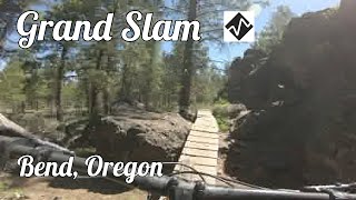
Mostly pretty easy singletrack, with some little rocky transitions and spots that will bite your rims as you try to maneuver through through the rocks. More down that up, but sometimes it is not easy to tell if you are climbing or going down as you pedal a lot through the ups and downs.

Adaptive Bike Info
aMTB Black Rating: Advanced obstacles exist, some trail obstructions.

aMTB rating is provided for general information only and may not reflect the technical difficulty of the trail or a particular rider's support needs. COTA completed a trail assessment process, please find more information on our website: https://www.cotamtb.com/amtb-trail-information.html. Contact Oregon Adaptive Sports for more information or ride support: https://oregonadaptivesports.org.

Local Trail Association

Recent Activity on Trail

Past Week
  • 15 rides
  • 18 miles average
6 Months
  • 120 rides
  • 20 miles avg distance
All
  • 1,148 rides
  • Last: Jun 17, 2026
c1c2c3c4
January
February
March
April
May
June
July
August
September
October
November
December
update trails status or condition

Grand Slam (Upper) Trail Reports

Status:
on May 6, 2026
Dry
Avg: 3.56 (10 votes)
Your vote: 0

view (9,271)
close
3D
Trail Conditions
  • Unknown
  • Snow Groomed
  • Snow Packed
  • Snow Covered
  • Snow Cover Partial
  • Freeze/thaw Cycle
  • Icy
  • Prevalent Mud
  • Wet
  • Variable
  • Ideal
  • Dry
  • Very Dry
Trail Flow (Ridden Direction)
Trailforks scans users ridelogs to determine the most popular direction each trail is ridden. A good flowing trail network will have most trails flowing in a single direction according to their intension.
The colour categories are based on what percentage of riders are riding a trail in its intended direction.
  • > 96%
  • > 90%
  • > 80%
  • > 70%
  • > 50%
  • < 50%
  • bi-directional trail
  • no data
Trail Last Ridden
Trailforks scans ridelogs to determine the last time a trail was ridden.
  • < 2 days
  • < 1 week
  • < 2 weeks
  • < 1 month
  • < 6 months
  • > 6 months
Trail Ridden Direction
The intended direction a trail should be ridden.
  • Downhill Only
  • Downhill Primary
  • Both Directions
  • Uphill Primary
  • Uphill Only
  • One Direction
Contribute Details
Colors indicate trail is missing specified detail.
  • Description
  • Photos
  • Description & Photos
  • Videos
Trail Popularity ?
Trailforks scans ridelogs to determine which trails are ridden the most in the last 9 months. Trails are compared with nearby trails in the same city region with a possible 25 colour shades. Think of this as a heatmap, more rides = more kinetic energy = warmer colors.
  • most popular
  • popular
  • less popular
  • not popular
ATV/ORV/OHV Filter
Max Vehicle Width
inches
US Cell Coverage
Legend
cell carrier legend

Radar Time
Activity Recordings
Trailforks uses anonymized public activity data. ?
Activity Recordings
Trailforks uses anonymized public activity data. ?
Personal Heatmap
Activity Types
all / none
Options
2
Date range month
Winter Trails
Warning A routing network for winter maps does not exist. Selecting trails using the winter trails layer has been disabled.
Missing Trails
Most Popular
Least Popular
Trails are colored based on popularity. The more popular a trail is, the more red. Less popular trails trend towards green.
Jump Magnitude Heatmap
Heatmap of where riders jump on trails. Zoom in to see individual jumps, click circles to view jump details.
BC Backroad Status

Service Road Atlas is a free to use, community-driven service for viewing and creating reports on the numerous back-country service roads around B.C. and Alberta.

map legend
Slope Aspect
Direction the slope faces
Flat N NE E SE S SW W NW
Trails Deemphasized
Trails are shown in grey.
disable
Only show trails with no bike usage.
Enable
Suggested Layers
Based on selected activity type

    Save the current map location and zoom level as your default home location whenever this page is loaded.

    Save
        Directions to grand-slam-upper trailhead (44.002660, -121.470310)

        Photos

        52 more »
        270 |
        Jun 10, 2008 @ 9:59am
        Jun 10, 2008
        1,134 |
        Jun 23, 2012 @ 7:18pm
        Jun 23, 2012
        51 |
        Oct 24, 2024 @ 6:35pm
        Oct 24, 2024
        42 |
        Oct 24, 2024 @ 6:34pm
        Oct 24, 2024

        Videos

        5 more »
        Grand Slam at the Phil's Riding Area in Bend,...
        11:18 | 208 | Jul 6, 2024 , Bend
        Upper Grand Slam at the Phil's Riding Area in...
        20:58 | 112 | Jun 29, 2024 , Bend
        Lower Grand Slam Chunky Bits
        0:06 | 420 | Nov 5, 2022 , Bend
        Lower Grand Slam in the snow..at night
        0:54 | 194 | Nov 5, 2022 , Bend

        Routes with this trail

        4.0 13 miles 821 ft 4
        !0 Barrel Riding Solo Fall 2020 - Week 3: Short Course - Lactic Sendydosis!
        18 miles 1,537 ft 5 Loop
        Loop: -> -> (s)->Marvin's G
        4.0 8 miles 584 ft 5
        storm king + cod

        Trail Products

        2 Reviews & Comments


        We hope you've been enjoying Trailforks!

        Create a FREE account to view trail comments and much more.

        Frequently Asked Questions About Grand Slam (Upper)

        Where is Grand Slam (Upper) located?
        Grand Slam (Upper) is located in Phil's, Bend, Oregon, United States. It is part of the Phil's trail network. The trailhead is located at coordinates 44.00266, -121.47031.
        How hard is Grand Slam (Upper)?
        Grand Slam (Upper) is rated as Blue difficulty. The average grade is 2.4%.
        What is the elevation gain for Grand Slam (Upper)?
        Grand Slam (Upper) has 48 ft of elevation gain. The trail has 352 ft of elevation descent. The elevation ranges from 4,320 ft to 4,650 ft.
        How long is Grand Slam (Upper)?
        Grand Slam (Upper) is 2.4 miles long. The trail type is singletrack.

        Hit the Trail

        Open in App

        Get this trail on your phone instantly.
        open trail in app

        Download Trail

        Save to wishlist, Garmin & download.
        save the trail

        Find Related Routes

        Find routes and users activities that include this trail.
        find routes for this trail

        You must enter a description before submitting.