more stats
2.5 miles
Distance
73 ft
Climb
-1,310 ft
Descent
00:25:08
Avg time
-1,238 ft
Altitude change
2,124 ft
Altitude min
3,362 ft
Altitude max
3,362 ft
Altitude start
2,126 ft
Altitude end
-9.3%
Grade
-41.1%
Grade max
14.5%
Grade min
1,194 ft
Distance climb
2 miles
Distance down
735 ft
Distance flat
00:25:08
Avg time

Green Door Details

  • Activities
    • Mountain Bike
    • E-Bike
    • Hike
    • Trail Running
  • Riding Area
    Monte Christo - KC
    Rossland, British Columbia
  • Difficulty Rating
  • Local Popularity
    60 in Mountain Biking [+]
    • 75 in E-Biking
    • 60 in Trail Running
    • 5 in Hiking
  • Global Ranking
    #74985 in Mountain Biking [+]
    • #48423 in E-Biking
    • #98769 in Trail Running
    • #131204 in Hiking
  • Trail Type
    Singletrack
  • Bike Type
    DH, AM, XC
  • Direction
    Downhill Only[+]
    Popular Direction Shown
    • Downhill Only for E-Biking
    • Downhill Only for Trail Running
    • Downhill Only for Hiking
  • Climb Difficulty
    Blue
  • Physical Rating
    Moderate
  • Season
    April - Nov
  • Dogs Allowed
    Yes
  • eBike Allowed
  • TTFs on Trail
    Bridge, Rock Face, Rock Garden
  • Ride in Rain
    Yes
  • OSM Way

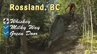
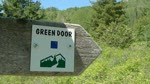
Don't let the name deceive you, this is an intermediate trail with a few tricky rocky sections. Also a great ride or shuttle for beginner riders looking for the next challenge. Very often ridden uphill to connect Milky Way (lower) to Roger's, so check your speed coming down.

The lower half is new school flow with some tight corners down to Warfield. Great trail design down a fairly steep ridge. Sandy dry terrain with corners and drops hardened by excellent rock work through forest and across rock slabs. Take the city bus back up or ride the Railgrade back to Rossland.

Local Trail Association

Recent Activity on Trail

Past Week
  • 1 rides
  • 10.0 km average
6 Months
  • 17 rides
  • 13.3 km avg distance
All
  • 197 rides
  • Last: Jun 15, 2026
c1c2c3c4
January
February
March
April
May
June
July
August
September
October
November
December
update trails status or condition

Green Door Trail Reports

statusdatedescription
May 31, 2026 @ 5:02pm (America/Vancouver)
May 31, 2026
Removed one tree that was blocking the trail near the bottom but it is getting quite overgrown in that same area
May 1, 2026 @ 7:55am (America/Vancouver)
May 1, 2026
reporter The KCTS trail crew completed seasonal inspection and maintenance.
Apr 26, 2026 @ 6:00pm (America/Vancouver)
Apr 26, 2026
Great conditions!
Mar 27, 2026 @ 3:00pm (America/Vancouver)
Mar 27, 2026
best conditions of the year :)
Aug 29, 2025 @ 1:00pm
Aug 29, 2025
downed tree
more »
Status:
on May 31, 2026
Ideal
Avg: 3.93 (9 votes)
Your vote: 0

view (1,140)
close
3D
Trail Conditions
  • Unknown
  • Snow Groomed
  • Snow Packed
  • Snow Covered
  • Snow Cover Partial
  • Freeze/thaw Cycle
  • Icy
  • Prevalent Mud
  • Wet
  • Variable
  • Ideal
  • Dry
  • Very Dry
Trail Flow (Ridden Direction)
Trailforks scans users ridelogs to determine the most popular direction each trail is ridden. A good flowing trail network will have most trails flowing in a single direction according to their intension.
The colour categories are based on what percentage of riders are riding a trail in its intended direction.
  • > 96%
  • > 90%
  • > 80%
  • > 70%
  • > 50%
  • < 50%
  • bi-directional trail
  • no data
Trail Last Ridden
Trailforks scans ridelogs to determine the last time a trail was ridden.
  • < 2 days
  • < 1 week
  • < 2 weeks
  • < 1 month
  • < 6 months
  • > 6 months
Trail Ridden Direction
The intended direction a trail should be ridden.
  • Downhill Only
  • Downhill Primary
  • Both Directions
  • Uphill Primary
  • Uphill Only
  • One Direction
Contribute Details
Colors indicate trail is missing specified detail.
  • Description
  • Photos
  • Description & Photos
  • Videos
Trail Popularity ?
Trailforks scans ridelogs to determine which trails are ridden the most in the last 9 months. Trails are compared with nearby trails in the same city region with a possible 25 colour shades. Think of this as a heatmap, more rides = more kinetic energy = warmer colors.
  • most popular
  • popular
  • less popular
  • not popular
ATV/ORV/OHV Filter
Max Vehicle Width
inches
US Cell Coverage
Legend
cell carrier legend

Radar Time
Activity Recordings
Trailforks uses anonymized public activity data. ?
Activity Recordings
Trailforks uses anonymized public activity data. ?
Personal Heatmap
Activity Types
all / none
Options
2
Date range month
Winter Trails
Warning A routing network for winter maps does not exist. Selecting trails using the winter trails layer has been disabled.
Missing Trails
Most Popular
Least Popular
Trails are colored based on popularity. The more popular a trail is, the more red. Less popular trails trend towards green.
Jump Magnitude Heatmap
Heatmap of where riders jump on trails. Zoom in to see individual jumps, click circles to view jump details.
BC Backroad Status

Service Road Atlas is a free to use, community-driven service for viewing and creating reports on the numerous back-country service roads around B.C. and Alberta.

map legend
Slope Aspect
Direction the slope faces
Flat N NE E SE S SW W NW
Trails Deemphasized
Trails are shown in grey.
disable
Only show trails with no bike usage.
Enable
Suggested Layers
Based on selected activity type

    Save the current map location and zoom level as your default home location whenever this page is loaded.

    Save
        Directions to green-door trailhead (49.084030, -117.777480)

        Photos

        39 more »
        446 |
        Jun 12, 2011 @ 6:45pm
        Jun 12, 2011
        222 |
        Jun 26, 2018 @ 1:57pm
        Jun 26, 2018
        1,242 |
        May 17, 2009 @ 7:40pm
        May 17, 2009
        615 |
        May 17, 2009 @ 7:40pm
        May 17, 2009

        Videos

        4 more »
        Best Destination - Green Door
        10:38 | 519 | Jul 13, 2020 , Rossland
        Whiskey on the Rocks & Green Door
        10:58 | 1084 | Oct 4, 2019 , Rossland
        youtuber Lower Green Door - Rossland, BC
        10:17 | 870 | Oct 5, 2018 , Rossland
        Bodhi on Green Door, Age 5
        0:16 | 1103 | Jul 7, 2010 , Rossland

        Routes with this trail

        5.0 38 miles 7,280 ft 28 Loop
        A long ride, almost all singletrack. Redtop up and down, Caldera, Eddie J, lower Mongoose, KC, Techno...
        3.5 6 miles 1,111 ft 14 Loop
        Park at the Centennial trailhead; ride up ; down ; down ; down Milky Way; then up Green Door / Roger's / /...
        4.0 6 miles 1,421 ft 11 Loop
        Park at the head; ride up KC; down and Milky Way; up Green Door to Roger's; down/up Roger's; down ; and up...

        6 Reviews & Comments


        We hope you've been enjoying Trailforks!

        Create a FREE account to view trail comments and much more.

        • By canadakaTF Pro Trailforks & contributors
        • #2172 - 9,205 views

        Frequently Asked Questions About Green Door

        Where is Green Door located?
        Green Door is located in Monte Christo - KC, Rossland, British Columbia, Canada. It is part of the Monte Christo - KC trail network. The trailhead is located at coordinates 49.08403, -117.77748.
        How hard is Green Door?
        Green Door is rated as Blue difficulty. The physical rating is Moderate. The average grade is 9.3%. The climb difficulty is rated Blue.
        What is the elevation gain for Green Door?
        Green Door has 22 m of elevation gain. The trail has 399 m of elevation descent. The elevation ranges from 648 m to 1,025 m.
        How long is Green Door?
        Green Door is 4.1 km long. The trail type is singletrack.

        Hit the Trail

        Open in App

        Get this trail on your phone instantly.
        open trail in app

        Download Trail

        Save to wishlist, Garmin & download.
        save the trail

        Find Related Routes

        Find routes and users activities that include this trail.
        find routes for this trail

        You must enter a description before submitting.