more stats
2.3 miles
Distance
531 ft
Climb
00:26:41
Avg time
532 ft
Altitude change
6,315 ft
Altitude min
6,847 ft
Altitude max
6,315 ft
Altitude start
6,847 ft
Altitude end
4.3%
Grade
-10%
Grade max
31.6%
Grade min
2 miles
Distance climb
102 ft
Distance down
1,365 ft
Distance flat
00:26:41
Avg time

Green Pond Details

  • Activities
    • Mountain Bike
    • Hike
    • Trail Running
  • Riding Area
    Snowbasin Resort
    Huntsville, Utah
  • Difficulty Rating
  • Voted Difficulty
    Green (3 votes)
  • Local Popularity
    90 in Mountain Biking [+]
    • 70 in Trail Running
    • 85 in Hiking
  • Global Ranking
    #48652 in Mountain Biking [+]
    • #61404 in Trail Running
    • #37065 in Hiking
  • Hiking SAC Scale
    T1 Hiking
  • Trail Type
    Singletrack
  • Bike Type
    AM, XC
  • Direction
    Both Directions
  • Climb Difficulty
    Green
  • Physical Rating
    Moderate
  • Dogs Allowed
    Yes

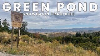
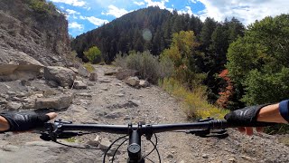
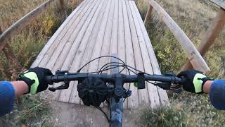
Of of the highlights of the Snowbasin trails. Lush riding through the tree's with a pretty little lake/pond in the middle. Lots of undulations and the occasional rocky patch keep it interesting.

Traditionally Indigenous Territory

Recent Activity on Trail

Past Week
  • 9 rides
  • 10 miles average
6 Months
  • 54 rides
  • 12 miles avg distance
All
  • 1,181 rides
  • Last: Jun 17, 2026
c1c2c3c4
January
February
March
April
May
June
July
August
September
October
November
December
update trails status or condition

Green Pond Trail Reports

Status:
on Jun 17, 2026
Very Dry
Avg: 4.23 (11 votes)
Your vote: 0

view (9,490)
close
3D
Trail Conditions
  • Unknown
  • Snow Groomed
  • Snow Packed
  • Snow Covered
  • Snow Cover Partial
  • Freeze/thaw Cycle
  • Icy
  • Prevalent Mud
  • Wet
  • Variable
  • Ideal
  • Dry
  • Very Dry
Trail Flow (Ridden Direction)
Trailforks scans users ridelogs to determine the most popular direction each trail is ridden. A good flowing trail network will have most trails flowing in a single direction according to their intension.
The colour categories are based on what percentage of riders are riding a trail in its intended direction.
  • > 96%
  • > 90%
  • > 80%
  • > 70%
  • > 50%
  • < 50%
  • bi-directional trail
  • no data
Trail Last Ridden
Trailforks scans ridelogs to determine the last time a trail was ridden.
  • < 2 days
  • < 1 week
  • < 2 weeks
  • < 1 month
  • < 6 months
  • > 6 months
Trail Ridden Direction
The intended direction a trail should be ridden.
  • Downhill Only
  • Downhill Primary
  • Both Directions
  • Uphill Primary
  • Uphill Only
  • One Direction
Contribute Details
Colors indicate trail is missing specified detail.
  • Description
  • Photos
  • Description & Photos
  • Videos
Trail Popularity ?
Trailforks scans ridelogs to determine which trails are ridden the most in the last 9 months. Trails are compared with nearby trails in the same city region with a possible 25 colour shades. Think of this as a heatmap, more rides = more kinetic energy = warmer colors.
  • most popular
  • popular
  • less popular
  • not popular
ATV/ORV/OHV Filter
Max Vehicle Width
inches
US Cell Coverage
Legend
cell carrier legend

Radar Time
Activity Recordings
Trailforks uses anonymized public activity data. ?
Activity Recordings
Trailforks uses anonymized public activity data. ?
Personal Heatmap
Activity Types
all / none
Options
2
Date range month
Winter Trails
Warning A routing network for winter maps does not exist. Selecting trails using the winter trails layer has been disabled.
Missing Trails
Most Popular
Least Popular
Trails are colored based on popularity. The more popular a trail is, the more red. Less popular trails trend towards green.
Jump Magnitude Heatmap
Heatmap of where riders jump on trails. Zoom in to see individual jumps, click circles to view jump details.
BC Backroad Status

Service Road Atlas is a free to use, community-driven service for viewing and creating reports on the numerous back-country service roads around B.C. and Alberta.

map legend
Slope Aspect
Direction the slope faces
Flat N NE E SE S SW W NW
Trails Deemphasized
Trails are shown in grey.
disable
Only show trails with no bike usage.
Enable
Suggested Layers
Based on selected activity type

    Save the current map location and zoom level as your default home location whenever this page is loaded.

    Save
        Directions to green-pond trailhead (41.206700, -111.835500)

        Photos

        53 more »
        71 |
        Jun 19, 2021 @ 8:11pm
        Jun 19, 2021
        64 |
        Jun 19, 2021 @ 8:08pm
        Jun 19, 2021
        81 |
        Oct 7, 2020 @ 4:47pm
        Oct 7, 2020
        83 |
        Aug 12, 2020 @ 5:03pm
        Aug 12, 2020

        Videos

        3 more »
        Green Pond MTB Trail - Snowbasin Resort Utah
        13:58 | 83 | Sep 16, 2025 , Huntsville
        Ogden, Ut MTB 1/3 | Wheeler Creek to Sardine...
        19:14 | 193 | Feb 20, 2024 , Huntsville
        Mountain Biking: Fall colors at Green Pond
        13:06 | 514 | Oct 4, 2021 , Huntsville

        Routes with this trail

        3.7 34 miles 5,108 ft 649 Loop
        This is the 50 k lap from the Mt ogden 100k race.
        5.0 6 miles 668 ft 6 Loop
        CCW TH loop. trail rock gardens up, then down for some smoother single track.
        3.0 20 miles 3,197 ft 12
        Big Loop of Area. Includes Lower , Sardine Loop, / Upper Wheeler, Art Nord / , ,

        1 Review & Comments


        We hope you've been enjoying Trailforks!

        Create a FREE account to view trail comments and much more.

        • By toddTF Pro Trailforks & contributors
        • #29380 - 6,691 views

        Frequently Asked Questions About Green Pond

        Where is Green Pond located?
        Green Pond is located in Snowbasin Resort, Huntsville, Utah, United States. It is part of the Snowbasin Resort trail network. The trailhead is located at coordinates 41.2067, -111.8355.
        How hard is Green Pond?
        Green Pond is rated as Green difficulty. The physical rating is Moderate. The average grade is 4.3%. The climb difficulty is rated Green.
        What is the elevation gain for Green Pond?
        Green Pond has 531 ft of elevation gain. The elevation ranges from 6,315 ft to 6,847 ft.
        Is Green Pond a point to point trail?
        Green Pond is not a point to point trail. The direction is Both Directions. The trail type is singletrack.

        Hit the Trail

        Open in App

        Get this trail on your phone instantly.
        open trail in app

        Download Trail

        Save to wishlist, Garmin & download.
        save the trail

        Find Related Routes

        Find routes and users activities that include this trail.
        find routes for this trail

        You must enter a description before submitting.