more stats
4,101 ft
Distance
28 ft
Climb
-635 ft
Descent
00:21:16
Avg time
-608 ft
Altitude change
610 ft
Altitude min
1,218 ft
Altitude max
1,218 ft
Altitude start
610 ft
Altitude end
-14.8%
Grade
-45.7%
Grade max
18.6%
Grade min
344 ft
Distance climb
3,068 ft
Distance down
689 ft
Distance flat
00:21:16
Avg time

Grinch Toes Details

  • Activities
    • Mountain Bike
    • E-Bike
    • Observed Trials
  • Riding Area
    Alice Lake & Highlands
    Squamish, British Columbia
  • Difficulty Rating
  • Voted Difficulty
    Double Black Diamond (5 votes)
  • Local Popularity
    60 in Mountain Biking [+]
    • 70 in E-Biking
    • 5 in Observed Trials
  • Global Ranking
    #50896 in Mountain Biking [+]
    • #43165 in E-Biking
    • #179 in Observed Trials
  • Trail Type
    Singletrack
  • Bike Type
    AM
  • Direction
    Downhill Only
    Popular Direction Shown
  • Physical Rating
    Hard
  • Season
    March - November
  • Dogs Allowed
    Yes
  • eBike Allowed
    Yes up to Class 1
  • TTFs on Trail
    Bridge, Drop, Rock Face

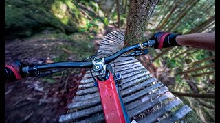
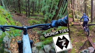
A technical trail offering higher level riders a little bit of everything - steeps, rock faces, rocks & rooty bits, and a few drops. If you can keep your momentum during the harder sections this trail offers some great flow. There are also a few climbs throughout, so have the dropper post ready for action.

Comparable in overall difficulty to Value Added, although both trails are unique when compared to each other.

Access Info

Use the same climbing route as to access Entrails, but turn right towards Value Added. At the Value Added sign that signifies the start of its climb, hang a right for Grinch Toes and the trail starts immediately.

Local Trail Association
Traditionally Indigenous Territory

Recent Activity on Trail

Past Week
  • 4 rides
  • 10 miles average
6 Months
  • 17 rides
  • 9 miles avg distance
All
  • 252 rides
  • Last: Jun 18, 2026
c1c2c3c4
January
February
March
April
May
June
July
August
September
October
November
December
update trails status or condition

Grinch Toes Trail Reports

statusdatedescription
Jun 9, 2026 @ 12:07pm (America/Vancouver)
Jun 9, 2026
Unclear why the iconic bridge has been replaced by this jumbled mess of rocks…?
May 30, 2026 @ 5:35pm (America/Vancouver)
May 30, 2026
cleared the tree
May 29, 2026 @ 6:50pm (America/Vancouver)
May 29, 2026
small tree down shortly after viewpoint. it's jammed in place so needs small saw
May 14, 2026 @ 1:32pm (America/Vancouver)
May 14, 2026
2 features are closed for trail work but there are ride arounds
Feb 11, 2026 @ 4:37pm (America/Vancouver)
Feb 11, 2026
All clear - riding well!
more »
Status:
on Jun 9, 2026
Variable
Avg: 4.41 (25 votes)
Your vote: 0

view (2,185)
close
3D
Trail Conditions
  • Unknown
  • Snow Groomed
  • Snow Packed
  • Snow Covered
  • Snow Cover Partial
  • Freeze/thaw Cycle
  • Icy
  • Prevalent Mud
  • Wet
  • Variable
  • Ideal
  • Dry
  • Very Dry
Trail Flow (Ridden Direction)
Trailforks scans users ridelogs to determine the most popular direction each trail is ridden. A good flowing trail network will have most trails flowing in a single direction according to their intension.
The colour categories are based on what percentage of riders are riding a trail in its intended direction.
  • > 96%
  • > 90%
  • > 80%
  • > 70%
  • > 50%
  • < 50%
  • bi-directional trail
  • no data
Trail Last Ridden
Trailforks scans ridelogs to determine the last time a trail was ridden.
  • < 2 days
  • < 1 week
  • < 2 weeks
  • < 1 month
  • < 6 months
  • > 6 months
Trail Ridden Direction
The intended direction a trail should be ridden.
  • Downhill Only
  • Downhill Primary
  • Both Directions
  • Uphill Primary
  • Uphill Only
  • One Direction
Contribute Details
Colors indicate trail is missing specified detail.
  • Description
  • Photos
  • Description & Photos
  • Videos
Trail Popularity ?
Trailforks scans ridelogs to determine which trails are ridden the most in the last 9 months. Trails are compared with nearby trails in the same city region with a possible 25 colour shades. Think of this as a heatmap, more rides = more kinetic energy = warmer colors.
  • most popular
  • popular
  • less popular
  • not popular
ATV/ORV/OHV Filter
Max Vehicle Width
inches
US Cell Coverage
Legend
cell carrier legend

Radar Time
Activity Recordings
Trailforks uses anonymized public activity data. ?
Activity Recordings
Trailforks uses anonymized public activity data. ?
Personal Heatmap
Activity Types
all / none
Options
2
Date range month
Winter Trails
Warning A routing network for winter maps does not exist. Selecting trails using the winter trails layer has been disabled.
Missing Trails
Most Popular
Least Popular
Trails are colored based on popularity. The more popular a trail is, the more red. Less popular trails trend towards green.
Jump Magnitude Heatmap
Heatmap of where riders jump on trails. Zoom in to see individual jumps, click circles to view jump details.
BC Backroad Status

Service Road Atlas is a free to use, community-driven service for viewing and creating reports on the numerous back-country service roads around B.C. and Alberta.

map legend
Slope Aspect
Direction the slope faces
Flat N NE E SE S SW W NW
Trails Deemphasized
Trails are shown in grey.
disable
Only show trails with no bike usage.
Enable
Suggested Layers
Based on selected activity type

    Save the current map location and zoom level as your default home location whenever this page is loaded.

    Save
        Directions to grinch-toes trailhead (49.765600, -123.113460)

        Photos

        47 more »
        100 |
        May 13, 2025 @ 10:43pm
        May 13, 2025
        340 |
        Nov 27, 2023 @ 10:58pm
        Nov 27, 2023
        303 |
        Nov 27, 2023 @ 10:58pm
        Nov 27, 2023
        275 |
        Nov 2, 2023 @ 10:10am
        Nov 2, 2023

        Videos

        9 more »
        youtuber This Double Black Trail Has a Little Bit of...
        10:26 | 511 | Dec 8, 2024 , Squamish
        youtuber Facebook said Grinch Toes was DUMBED DOWN,  ...
        11:24 | 101 | Apr 15, 2026 , Squamish
        youtuber GRINCH TOES | Double black trail | Squamish -...
        6:03 | 268 | Dec 20, 2023 , Squamish
        youtuber E MTBing on Grinch Toes in Squamish BC: The...
        13:34 | 818 | Oct 26, 2022 , Squamish

        Routes with this trail

        6 miles 1,080 ft 9
        Grinch Toes > Icy Hole of Death > The Donut
        29 miles 6,537 ft 37
        Tentative Mega Ride options. Spring Tune Up 2024
        27 miles 5,798 ft 36
        Spring Tune up 2024. Mega Ride option

        8 Reviews & Comments


        We hope you've been enjoying Trailforks!

        Create a FREE account to view trail comments and much more.

        • By canadakaTF Pro Trailforks & contributors
        • #33392 - 9,160 views

        Frequently Asked Questions About Grinch Toes

        Where is Grinch Toes located?
        Grinch Toes is located in Alice Lake & Highlands, Squamish, British Columbia, Canada. It is part of the Alice Lake & Highlands trail network. The trailhead is located at coordinates 49.7656, -123.11346.
        How hard is Grinch Toes?
        Grinch Toes is rated as Double Black Diamond difficulty. The physical rating is Hard. The average grade is 14.8%.
        What is the elevation gain for Grinch Toes?
        Grinch Toes has 28 ft of elevation gain. The trail has 635 ft of elevation descent. The elevation ranges from 610 ft to 1,218 ft.
        Is Grinch Toes a point to point trail?
        Yes, Grinch Toes is a point to point trail. The direction is Downhill Only. The trail type is singletrack.

        Hit the Trail

        Open in App

        Get this trail on your phone instantly.
        open trail in app

        Download Trail

        Save to wishlist, Garmin & download.
        save the trail

        Find Related Routes

        Find routes and users activities that include this trail.
        find routes for this trail

        You must enter a description before submitting.