more stats
4,216 ft
Distance
112 ft
Climb
-270 ft
Descent
00:15:23
Avg time
-158 ft
Altitude change
4,494 ft
Altitude min
4,727 ft
Altitude max
4,653 ft
Altitude start
4,495 ft
Altitude end
-3.8%
Grade
-32.9%
Grade max
12.5%
Grade min
1,854 ft
Distance climb
2,198 ft
Distance down
164 ft
Distance flat
00:15:23
Avg time

Ground Control Details

  • Activities
    • Mountain Bike
    • Hike
    • Trail Running
  • Riding Area
    Western Gateway
    Sedona, Arizona
  • Difficulty Rating
  • Voted Difficulty
    Black Diamond (6 votes)
  • Local Popularity
    85 in Mountain Biking [+]
    • 65 in Trail Running
    • 50 in Hiking
  • Global Ranking
    #4238 in Mountain Biking [+]
    • #60685 in Trail Running
    • #81289 in Hiking
  • Hiking SAC Scale
    T1 Hiking
  • Trail Type
    Singletrack
  • Bike Type
    AM
  • Direction
    One Direction
    Popular Direction Shown
  • Trail Visibility
    Always easy to follow
  • Season
    All Season
  • Dogs Allowed
    Yes
  • eBike Allowed
  • TTFs on Trail
    Berm, Drop, Rock Face, Other
  • Year Opened
    2020
  • Land Owner
    USFS

Ground Control is one of the Western Gateway trails built by the USFS and mostly local Sedona volunteers. The only direction to ride the trail is north to south (Cockscomb to Outer Limits).

Tthe trail has some expert sections the will definitely challenge some advanced riders. There are several uphill sections over to the steep challenging downhilll section, some riders might walk. The trail tread on the traverse is constructed with soil with very little clay content, so it will be constantly eroding where it isn't supported by large rock. Shortly before making to the downhill section there are two short challenging steep step-ups, that some advanced riders might not clean.

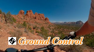
The views on the trail before the challenging switchbacks are World Class to the northwest and northeast.

As you ride off the high point of the trail you are instantly wondering what kind of steep challenging terrain lays ahead of you. Hopefully your bike has a dropper post to give you a more enjoyable ride to the bottom. Halfway down the downhill section there is an expert spot on the left side or easier rocked berm line on the right. After that point trail becomes easier to ride.

Local Trail Association

Recent Activity on Trail

Past Week
  • 0 rides
  •  
6 Months
  • 116 rides
  • 16 miles avg distance
All
  • 882 rides
  • Last: Jun 9, 2026
c1c2c3c4
January
February
March
April
May
June
July
August
September
October
November
December
Status:
on Apr 22, 2026
Dry
Avg: 4.5 (43 votes)
Your vote: 0

view (4,495)
close
3D
Trail Conditions
  • Unknown
  • Snow Groomed
  • Snow Packed
  • Snow Covered
  • Snow Cover Partial
  • Freeze/thaw Cycle
  • Icy
  • Prevalent Mud
  • Wet
  • Variable
  • Ideal
  • Dry
  • Very Dry
Trail Flow (Ridden Direction)
Trailforks scans users ridelogs to determine the most popular direction each trail is ridden. A good flowing trail network will have most trails flowing in a single direction according to their intension.
The colour categories are based on what percentage of riders are riding a trail in its intended direction.
  • > 96%
  • > 90%
  • > 80%
  • > 70%
  • > 50%
  • < 50%
  • bi-directional trail
  • no data
Trail Last Ridden
Trailforks scans ridelogs to determine the last time a trail was ridden.
  • < 2 days
  • < 1 week
  • < 2 weeks
  • < 1 month
  • < 6 months
  • > 6 months
Trail Ridden Direction
The intended direction a trail should be ridden.
  • Downhill Only
  • Downhill Primary
  • Both Directions
  • Uphill Primary
  • Uphill Only
  • One Direction
Contribute Details
Colors indicate trail is missing specified detail.
  • Description
  • Photos
  • Description & Photos
  • Videos
Trail Popularity ?
Trailforks scans ridelogs to determine which trails are ridden the most in the last 9 months. Trails are compared with nearby trails in the same city region with a possible 25 colour shades. Think of this as a heatmap, more rides = more kinetic energy = warmer colors.
  • most popular
  • popular
  • less popular
  • not popular
ATV/ORV/OHV Filter
Max Vehicle Width
inches
US Cell Coverage
Legend
cell carrier legend

Radar Time
Activity Recordings
Trailforks uses anonymized public activity data. ?
Activity Recordings
Trailforks uses anonymized public activity data. ?
Personal Heatmap
Activity Types
all / none
Options
2
Date range month
Winter Trails
Warning A routing network for winter maps does not exist. Selecting trails using the winter trails layer has been disabled.
Missing Trails
Most Popular
Least Popular
Trails are colored based on popularity. The more popular a trail is, the more red. Less popular trails trend towards green.
Jump Magnitude Heatmap
Heatmap of where riders jump on trails. Zoom in to see individual jumps, click circles to view jump details.
BC Backroad Status

Service Road Atlas is a free to use, community-driven service for viewing and creating reports on the numerous back-country service roads around B.C. and Alberta.

map legend
Slope Aspect
Direction the slope faces
Flat N NE E SE S SW W NW
Trails Deemphasized
Trails are shown in grey.
disable
Only show trails with no bike usage.
Enable
Suggested Layers
Based on selected activity type

    Save the current map location and zoom level as your default home location whenever this page is loaded.

    Save
        Directions to ground-control-249974 trailhead (34.878500, -111.859950)

        Photos

        31 more »
        532 |
        Feb 2, 2020 @ 10:29pm
        Feb 2, 2020
        428 |
        Jan 31, 2020 @ 12:15am
        Jan 31, 2020
        36 |
        Feb 12, 2026 @ 6:11pm
        Feb 12, 2026
        108 |
        Oct 7, 2023 @ 3:45pm
        Oct 7, 2023

        Videos

        11 more »
        youtuber Are These The BEST Trails In SEDONA?  (Ground...
        14:18 | 456 | Mar 20, 2023 , Sedona
        youtuber REVIEW: The 2020 Marin Pine Mountain 2 as a...
        23:40 | 961 | May 27, 2020 , Sedona
        youtuber Sedona's newest Black Diamond trail | GROUND...
        5:27 | 1117 | Mar 27, 2020 , Sedona
        youtuber Best expert mountain bike trail in Sedona, AZ...
        12:41 | 177 | Apr 22, 2025 , Sedona

        Routes with this trail

        3.7 22 miles 2,043 ft 10 Loop
        Park at cultural center, ride to Chuckwagon and continue long loop in a counterclockwise direction....
        3.5 18 miles 1,723 ft 8 Loop
        Moderate loop for the intermediate to advanced rider that hits most of the goods in the area. , , , Ground...
        4.0 14 miles 1,338 ft 7
        Recommended ride by thunder mountain bikes if you're looking to do , , Ground Control and Aerie.

        17 Reviews & Comments


        We hope you've been enjoying Trailforks!

        Create a FREE account to view trail comments and much more.

        • By johnf0246TF Pro & contributors
        • #249974 - 12,906 views

        Frequently Asked Questions About Ground Control

        Where is Ground Control located?
        Ground Control is located in Western Gateway, Sedona, Arizona, United States. It is part of the Western Gateway trail network. The trailhead is located at coordinates 34.8785, -111.85995.
        How hard is Ground Control?
        Ground Control is rated as Black Diamond difficulty. The average grade is 3.8%.
        What is the elevation gain for Ground Control?
        Ground Control has 112 ft of elevation gain. The trail has 270 ft of elevation descent. The elevation ranges from 4,494 ft to 4,727 ft.
        Is Ground Control a point to point trail?
        Yes, Ground Control is a point to point trail. The direction is One Direction. The trail type is singletrack.

        Hit the Trail

        Open in App

        Get this trail on your phone instantly.
        open trail in app

        Download Trail

        Save to wishlist, Garmin & download.
        save the trail

        Find Related Routes

        Find routes and users activities that include this trail.
        find routes for this trail

        You must enter a description before submitting.