more stats
6.1 miles
Distance
149 ft
Climb
-2,121 ft
Descent
00:51:50
Avg time
-1,972 ft
Altitude change
7,733 ft
Altitude min
9,737 ft
Altitude max
9,737 ft
Altitude start
7,766 ft
Altitude end
-6.1%
Grade
-50.2%
Grade max
47.5%
Grade min
2,602 ft
Distance climb
5 miles
Distance down
2,041 ft
Distance flat
00:51:50
Avg time

Guaje Ridge Details

  • Activities
    • Mountain Bike
    • Hike
    • Trail Running
  • Riding Area
    Los Alamos
    , New Mexico
  • Difficulty Rating
  • Voted Difficulty
    Blue (1 vote)
  • Local Popularity
    65 in Mountain Biking [+]
    • 80 in Trail Running
    • 5 in Hiking
  • Global Ranking
    #80801 in Mountain Biking [+]
    • #30435 in Trail Running
    • #122873 in Hiking
  • Hiking SAC Scale
    T2 Mountain Hiking
  • Trail Exposure
    Normal
  • Trail Type
    Singletrack
  • Bike Type
    AM
  • Direction
    Downhill Primary
    Popular Direction Shown
  • Physical Rating
    Hard
  • Trail Visibility
    Always easy to follow
  • Season
    May-October
  • Dogs Allowed
    Yes
  • Lighting
    No
  • Land Owner
    Santa Fe National Forest

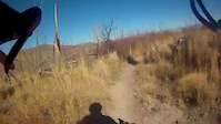
Normally shuttled from Pajarito Ski Area but can be done as a loop up Quemazon & Pipeline, down Guaje Ridge & Cabra, and Perimeter back to town. From Pajarito Ski Area to the trail head via Pipeline is fairly steep and will take 30-60 minutes but once on Guaje Ridge it is mostly descending. Awesome trail but gets a lot of locust thorn bushes once the monsoons start. Best time to ride it is late May/early June after the trail is used for the Jemez Mountain Run.

Trail Supporters

  • USFS
    Land Manager
Local Trail Association
Traditionally Indigenous Territory

Recent Activity on Trail

Past Week
  • 0 rides
  •  
6 Months
  • 7 rides
  • 17 miles avg distance
All
  • 36 rides
  • Last: Jun 14, 2026
c1c2c3c4
January
February
March
April
May
June
July
August
September
October
November
December
update trails status or condition

Guaje Ridge Trail Reports

statusdatedescription
Mar 25, 2026 @ 9:00am (America/Denver)
Mar 25, 2026
A few downed trees on top section, one corner with snow on trail, but only about 30 ft long.
Mar 24, 2026 @ 6:46pm (America/Denver)
Mar 24, 2026
There are 7 or 8 trees down, all but one on the first descent - but riding well, because... no locust problems! Someone cleared it out already...
Aug 30, 2025 @ 2:43pm
Aug 30, 2025
Middle 2-3 miles is pretty overgrown with locust as of 8/20/25
Oct 27, 2024 @ 7:51pm
Oct 27, 2024
Pretty brushy with locust above Mitchell. I took Mitchell down, but I’m guessing lower guaje is brushy too. Upper guaje is fine for hiking, ok...
Sep 10, 2024 @ 11:21am
Sep 10, 2024
There's quite a bit of locust as of 9/10/24, so about 50% of the trail is fairly unpleasant. There was a fellow out clearing brush by hand with...
more »
Status:
on Mar 25, 2026
Variable
Avg: 3.89 (4 votes)
Your vote: 0

view (205)
close
3D
Trail Conditions
  • Unknown
  • Snow Groomed
  • Snow Packed
  • Snow Covered
  • Snow Cover Partial
  • Freeze/thaw Cycle
  • Icy
  • Prevalent Mud
  • Wet
  • Variable
  • Ideal
  • Dry
  • Very Dry
Trail Flow (Ridden Direction)
Trailforks scans users ridelogs to determine the most popular direction each trail is ridden. A good flowing trail network will have most trails flowing in a single direction according to their intension.
The colour categories are based on what percentage of riders are riding a trail in its intended direction.
  • > 96%
  • > 90%
  • > 80%
  • > 70%
  • > 50%
  • < 50%
  • bi-directional trail
  • no data
Trail Last Ridden
Trailforks scans ridelogs to determine the last time a trail was ridden.
  • < 2 days
  • < 1 week
  • < 2 weeks
  • < 1 month
  • < 6 months
  • > 6 months
Trail Ridden Direction
The intended direction a trail should be ridden.
  • Downhill Only
  • Downhill Primary
  • Both Directions
  • Uphill Primary
  • Uphill Only
  • One Direction
Contribute Details
Colors indicate trail is missing specified detail.
  • Description
  • Photos
  • Description & Photos
  • Videos
Trail Popularity ?
Trailforks scans ridelogs to determine which trails are ridden the most in the last 9 months. Trails are compared with nearby trails in the same city region with a possible 25 colour shades. Think of this as a heatmap, more rides = more kinetic energy = warmer colors.
  • most popular
  • popular
  • less popular
  • not popular
ATV/ORV/OHV Filter
Max Vehicle Width
inches
US Cell Coverage
Legend
cell carrier legend

Radar Time
Activity Recordings
Trailforks uses anonymized public activity data. ?
Activity Recordings
Trailforks uses anonymized public activity data. ?
Personal Heatmap
Activity Types
all / none
Options
2
Date range month
Winter Trails
Warning A routing network for winter maps does not exist. Selecting trails using the winter trails layer has been disabled.
Missing Trails
Most Popular
Least Popular
Trails are colored based on popularity. The more popular a trail is, the more red. Less popular trails trend towards green.
Jump Magnitude Heatmap
Heatmap of where riders jump on trails. Zoom in to see individual jumps, click circles to view jump details.
BC Backroad Status

Service Road Atlas is a free to use, community-driven service for viewing and creating reports on the numerous back-country service roads around B.C. and Alberta.

map legend
Slope Aspect
Direction the slope faces
Flat N NE E SE S SW W NW
Trails Deemphasized
Trails are shown in grey.
disable
Only show trails with no bike usage.
Enable
Suggested Layers
Based on selected activity type

    Save the current map location and zoom level as your default home location whenever this page is loaded.

    Save
        Directions to guaje-ridge trailhead (35.922140, -106.369040)

        Photos

        6 more »
        90 |
        Feb 23, 2025 @ 5:48pm
        Feb 23, 2025
        251 |
        Jun 23, 2019 @ 5:35pm
        Jun 23, 2019
        215 |
        Jun 23, 2019 @ 4:34pm
        Jun 23, 2019
        257 |
        Jun 23, 2019 @ 4:34pm
        Jun 23, 2019

        Videos

        1 more »
        Drop bar DH on a bamboo road bike
        9:37 | 277 | Oct 26, 2016 , Los Alamos

        Routes with this trail

        11 miles 1,094 ft 10 Shuttled
        A shuttled route starting from the base of mountain and ending near los alamos high school. Grab a buddy,...

        8 Reviews & Comments


        We hope you've been enjoying Trailforks!

        Create a FREE account to view trail comments and much more.

        • By nealpedersonTF Pro LATR & contributors
        • #16994 - 3,172 views

        Frequently Asked Questions About Guaje Ridge

        Where is Guaje Ridge located?
        Guaje Ridge is located in Los Alamos, New Mexico, United States. It is part of the Los Alamos trail network. The trailhead is located at coordinates 35.92214, -106.36904.
        How hard is Guaje Ridge?
        Guaje Ridge is rated as Black Diamond difficulty. The physical rating is Hard. The average grade is 6.1%.
        What is the elevation gain for Guaje Ridge?
        Guaje Ridge has 149 ft of elevation gain. The trail has 2,121 ft of elevation descent. The elevation ranges from 7,733 ft to 9,737 ft.
        Is Guaje Ridge a point to point trail?
        Guaje Ridge is not a point to point trail. The direction is Downhill Primary. The trail type is singletrack.

        Hit the Trail

        Open in App

        Get this trail on your phone instantly.
        open trail in app

        Download Trail

        Save to wishlist, Garmin & download.
        save the trail

        Find Related Routes

        Find routes and users activities that include this trail.
        find routes for this trail

        You must enter a description before submitting.