more stats
3.0 miles
Distance
393 ft
Climb
-463 ft
Descent
00:34:17
Avg time
-69 ft
Altitude change
4,298 ft
Altitude min
4,542 ft
Altitude max
4,397 ft
Altitude start
4,327 ft
Altitude end
-0.4%
Grade
-25.4%
Grade max
27%
Grade min
1 mile
Distance climb
1 mile
Distance down
1,854 ft
Distance flat
00:34:17
Avg time

Guy Lafleur Details

  • Activities
    • Mountain Bike
    • Hike
    • Trail Running
  • Riding Area
  • AKA
    Quebexican
  • Difficulty Rating
  • Local Popularity
    55 in Mountain Biking [+]
    • 85 in Trail Running
    • 50 in Hiking
  • Global Ranking
    #90651 in Mountain Biking [+]
    • #19763 in Trail Running
    • #107172 in Hiking
  • Trail Type
    Singletrack
  • Bike Type
    XC
  • Direction
    Both Directions
  • Climb Difficulty
    Blue
  • Physical Rating
    Moderate
  • Season
    Apr-Oct
  • Dogs Allowed
    Yes
  • Land Owner

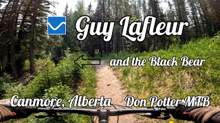
Energy sapping loam makes this one seem far out there even though its within arm's reach of the highway.
Rooty classic old school single track at its best.
This trail is now named "Guy Lafleur" by approval of the original builder.

Access Info

Please access trail from the end of Three Sisters Parkway to the left of the gate.

Local Trail Association

Recent Activity on Trail

Past Week
  • 1 rides
  • 8 miles average
6 Months
  • 9 rides
  • 18 miles avg distance
All
  • 124 rides
  • Last: Jun 13, 2026
c1c2c3c4
January
February
March
April
May
June
July
August
September
October
November
December
update trails status or condition

Guy Lafleur Trail Reports

statusdatedescription
Jun 15, 2026 @ 5:05pm (America/Edmonton)
Jun 15, 2026
East access bridge from Deadman’s is submerged under the creek and impassable.
Jun 6, 2026 @ 1:47pm (America/Edmonton)
Jun 6, 2026
Jun 2, 2026 @ 6:24pm (America/Edmonton)
Jun 2, 2026
Bridge to cross Pigeon Creek is messed up.
May 13, 2026 @ 4:00pm (America/Edmonton)
May 13, 2026
Deadfall has been cleared. Trail in good condition.
May 10, 2026 @ 7:34pm (America/Edmonton)
May 10, 2026
All the snow and ice is gone. Very few mud spots, otherwise nicely dry.
more »
Status:
on Jun 15, 2026
Avg: 3.43 (22 votes)
Your vote: 0

view (912)
close
3D
Trail Conditions
  • Unknown
  • Snow Groomed
  • Snow Packed
  • Snow Covered
  • Snow Cover Partial
  • Freeze/thaw Cycle
  • Icy
  • Prevalent Mud
  • Wet
  • Variable
  • Ideal
  • Dry
  • Very Dry
Trail Flow (Ridden Direction)
Trailforks scans users ridelogs to determine the most popular direction each trail is ridden. A good flowing trail network will have most trails flowing in a single direction according to their intension.
The colour categories are based on what percentage of riders are riding a trail in its intended direction.
  • > 96%
  • > 90%
  • > 80%
  • > 70%
  • > 50%
  • < 50%
  • bi-directional trail
  • no data
Trail Last Ridden
Trailforks scans ridelogs to determine the last time a trail was ridden.
  • < 2 days
  • < 1 week
  • < 2 weeks
  • < 1 month
  • < 6 months
  • > 6 months
Trail Ridden Direction
The intended direction a trail should be ridden.
  • Downhill Only
  • Downhill Primary
  • Both Directions
  • Uphill Primary
  • Uphill Only
  • One Direction
Contribute Details
Colors indicate trail is missing specified detail.
  • Description
  • Photos
  • Description & Photos
  • Videos
Trail Popularity ?
Trailforks scans ridelogs to determine which trails are ridden the most in the last 9 months. Trails are compared with nearby trails in the same city region with a possible 25 colour shades. Think of this as a heatmap, more rides = more kinetic energy = warmer colors.
  • most popular
  • popular
  • less popular
  • not popular
ATV/ORV/OHV Filter
Max Vehicle Width
inches
US Cell Coverage
Legend
cell carrier legend

Radar Time
Activity Recordings
Trailforks uses anonymized public activity data. ?
Activity Recordings
Trailforks uses anonymized public activity data. ?
Personal Heatmap
Activity Types
all / none
Options
2
Date range month
Winter Trails
Warning A routing network for winter maps does not exist. Selecting trails using the winter trails layer has been disabled.
Missing Trails
Most Popular
Least Popular
Trails are colored based on popularity. The more popular a trail is, the more red. Less popular trails trend towards green.
Jump Magnitude Heatmap
Heatmap of where riders jump on trails. Zoom in to see individual jumps, click circles to view jump details.
BC Backroad Status

Service Road Atlas is a free to use, community-driven service for viewing and creating reports on the numerous back-country service roads around B.C. and Alberta.

map legend
Slope Aspect
Direction the slope faces
Flat N NE E SE S SW W NW
Trails Deemphasized
Trails are shown in grey.
disable
Only show trails with no bike usage.
Enable
Suggested Layers
Based on selected activity type

    Save the current map location and zoom level as your default home location whenever this page is loaded.

    Save
        Directions to guy-lafleur trailhead (51.046690, -115.300910)

        Photos

        47 more »
        951 |
        Sep 11, 2012 @ 7:28pm
        Sep 11, 2012
        480 |
        May 12, 2019 @ 7:26pm
        May 12, 2019
        354 |
        Jul 9, 2018 @ 8:57pm
        Jul 9, 2018
        14 |
        Jun 17, 2026 @ 12:20am
        3 days

        Videos

        2 more »
        Guy Lafleur in Canmore, Alberta
        31:19 | 56 | Nov 22, 2025 , Canmore
        Mountain Biking the Guy Lafleur Trail,...
        11:37 | 77 | Jun 22, 2025 , Canmore

        Routes with this trail

        4.0 8 miles 985 ft 4 Loop
        This is an option for a loop between the east end of the Canmore township to the Dead Man’s Flat...
        5.0 30 miles 4,689 ft 48
        CNC Start - Highline - Guy Lafleur - Deadmans to refuel - Reverse - - CNC Hot Lap
        10 miles 2,082 ft 5 Point to Point
        its the party lap of cloudline to guylafluer but with a bit of suffering tossed in by highline to make...

        6 Reviews & Comments


        We hope you've been enjoying Trailforks!

        Create a FREE account to view trail comments and much more.

        • By racerfacerTF Pro & contributors
        • #32895 - 13,787 views

        Frequently Asked Questions About Guy Lafleur

        Where is Guy Lafleur located?
        Guy Lafleur is located in Three Sisters Mountain Village, Canmore, Alberta, Canada. It is part of the Three Sisters Mountain Village trail network. The trailhead is located at coordinates 51.04669, -115.30091.
        How hard is Guy Lafleur?
        Guy Lafleur is rated as Blue difficulty. The physical rating is Moderate. The average grade is 0.4%. The climb difficulty is rated Blue.
        What is the elevation gain for Guy Lafleur?
        Guy Lafleur has 120 m of elevation gain. The trail has 141 m of elevation descent. The elevation ranges from 1,310 m to 1,385 m.
        Is Guy Lafleur a point to point trail?
        Guy Lafleur is not a point to point trail. The direction is Both Directions. The trail type is singletrack.

        Hit the Trail

        Open in App

        Get this trail on your phone instantly.
        open trail in app

        Download Trail

        Save to wishlist, Garmin & download.
        save the trail

        Find Related Routes

        Find routes and users activities that include this trail.
        find routes for this trail

        You must enter a description before submitting.