more stats
1.6 miles
Distance
16 ft
Climb
-976 ft
Descent
00:08:01
Avg time
-962 ft
Altitude change
6,894 ft
Altitude min
7,856 ft
Altitude max
7,856 ft
Altitude start
6,893 ft
Altitude end
-11.4%
Grade
-41.9%
Grade max
9.7%
Grade min
420 ft
Distance climb
1 mile
Distance down
630 ft
Distance flat
00:08:01
Avg time

Gypsy Details

  • Activities
    • Mountain Bike
    • E-Bike
  • Riding Area
    Northstar at Tahoe Resort
    Truckee, California
  • Difficulty Rating
  • Voted Difficulty
    Black Diamond (4 votes)
  • Local Popularity
    100 in Mountain Biking [+]
    • 100 in E-Biking
  • Global Ranking
    #22324 in Mountain Biking [+]
    • #2296 in E-Biking
  • Trail Type
    Singletrack
  • Bike Type
    DH
  • Physical Rating
    Moderate
  • Season
    Summer
  • Dogs Allowed
    Yes
  • eBike Allowed
    Yes up to Class 1
  • TTFs on Trail
    A-Frame, Berm, Bridge, Drop, Jump, Rock Face, Rock Garden
  • Year Opened
    2013

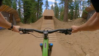
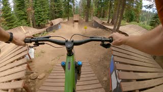
New Gypsy was made during the 2013 season. It is now mostly wooden features with the occasional jump and some rocks. A very technical riding trail.

Access Info

Follow the signs on the Zephyr fire road. The trail is marked and starts on the right.

Bike Park

Traditionally Indigenous Territory

Recent Activity on Trail

Past Week
  • 20 rides
  • 26 miles average
6 Months
  • 37 rides
  • 23 miles avg distance
All
  • 709 rides
  • Last: Jun 21, 2026
c1c2c3c4
January
February
March
April
May
June
July
August
September
October
November
December
update trails status or condition

Gypsy Trail Reports

Status:
on Jun 23, 2024
Very Dry
Avg: 4.61 (25 votes)
Your vote: 0

view (11,059)
close
3D
Trail Conditions
  • Unknown
  • Snow Groomed
  • Snow Packed
  • Snow Covered
  • Snow Cover Partial
  • Freeze/thaw Cycle
  • Icy
  • Prevalent Mud
  • Wet
  • Variable
  • Ideal
  • Dry
  • Very Dry
Trail Flow (Ridden Direction)
Trailforks scans users ridelogs to determine the most popular direction each trail is ridden. A good flowing trail network will have most trails flowing in a single direction according to their intension.
The colour categories are based on what percentage of riders are riding a trail in its intended direction.
  • > 96%
  • > 90%
  • > 80%
  • > 70%
  • > 50%
  • < 50%
  • bi-directional trail
  • no data
Trail Last Ridden
Trailforks scans ridelogs to determine the last time a trail was ridden.
  • < 2 days
  • < 1 week
  • < 2 weeks
  • < 1 month
  • < 6 months
  • > 6 months
Trail Ridden Direction
The intended direction a trail should be ridden.
  • Downhill Only
  • Downhill Primary
  • Both Directions
  • Uphill Primary
  • Uphill Only
  • One Direction
Contribute Details
Colors indicate trail is missing specified detail.
  • Description
  • Photos
  • Description & Photos
  • Videos
Trail Popularity ?
Trailforks scans ridelogs to determine which trails are ridden the most in the last 9 months. Trails are compared with nearby trails in the same city region with a possible 25 colour shades. Think of this as a heatmap, more rides = more kinetic energy = warmer colors.
  • most popular
  • popular
  • less popular
  • not popular
ATV/ORV/OHV Filter
Max Vehicle Width
inches
US Cell Coverage
Legend
cell carrier legend

Radar Time
Activity Recordings
Trailforks uses anonymized public activity data. ?
Activity Recordings
Trailforks uses anonymized public activity data. ?
Personal Heatmap
Activity Types
all / none
Options
2
Date range month
Winter Trails
Warning A routing network for winter maps does not exist. Selecting trails using the winter trails layer has been disabled.
Missing Trails
Most Popular
Least Popular
Trails are colored based on popularity. The more popular a trail is, the more red. Less popular trails trend towards green.
Jump Magnitude Heatmap
Heatmap of where riders jump on trails. Zoom in to see individual jumps, click circles to view jump details.
BC Backroad Status

Service Road Atlas is a free to use, community-driven service for viewing and creating reports on the numerous back-country service roads around B.C. and Alberta.

map legend
Slope Aspect
Direction the slope faces
Flat N NE E SE S SW W NW
Trails Deemphasized
Trails are shown in grey.
disable
Only show trails with no bike usage.
Enable
Suggested Layers
Based on selected activity type

    Save the current map location and zoom level as your default home location whenever this page is loaded.

    Save
        Directions to gypsy trailhead (39.257070, -120.139600)

        Photos

        48 more »
        218 |
        Oct 3, 2021 @ 10:54pm
        Oct 3, 2021
        213 |
        Aug 2, 2020 @ 1:24pm
        Aug 2, 2020
        306 |
        Aug 26, 2019 @ 8:13pm
        Aug 26, 2019
        286 |
        Aug 26, 2019 @ 8:14pm
        Aug 26, 2019

        Videos

        75 more »
        youtuber Northstar - Runs 1-5 (Truckee, CA) Mountain Biking
        17:40 | 841 | Jul 21, 2018 , Truckee
        youtuber Gypsy / Northstar Bike Park
        6:46 | 81 | Aug 5, 2022 , Truckee
        youtuber Gypsy / Northstar Bike Park
        5:54 | 384 | Aug 17, 2023 , Truckee
        youtuber Gypsy / Northstar Bike Park
        5:39 | 281 | Aug 12, 2024 , Truckee

        6 Reviews & Comments


        We hope you've been enjoying Trailforks!

        Create a FREE account to view trail comments and much more.

        • By chriscliffordTF Pro & contributors
        • #5645 - 9,100 views

        Frequently Asked Questions About Gypsy

        Where is Gypsy located?
        Gypsy is located in Northstar at Tahoe Resort, Truckee, California, United States. It is part of the Northstar at Tahoe Resort trail network. The trailhead is located at coordinates 39.25707, -120.1396.
        How hard is Gypsy?
        Gypsy is rated as Black Diamond difficulty. The physical rating is Moderate. The average grade is 11.4%.
        What is the elevation gain for Gypsy?
        Gypsy has 16 ft of elevation gain. The trail has 976 ft of elevation descent. The elevation ranges from 6,894 ft to 7,856 ft.
        How long is Gypsy?
        Gypsy is 1.6 miles long. The trail type is singletrack.

        Hit the Trail

        Open in App

        Get this trail on your phone instantly.
        open trail in app

        Download Trail

        Save to wishlist, Garmin & download.
        save the trail

        Find Related Routes

        Find routes and users activities that include this trail.
        find routes for this trail

        You must enter a description before submitting.