more stats
1.0 mile
Distance
-681 ft
Descent
00:13:59
Avg time
-681 ft
Altitude change
2,586 ft
Altitude min
3,269 ft
Altitude max
3,268 ft
Altitude start
2,585 ft
Altitude end
-12.7%
Grade
-53.4%
Grade max
1.5%
Grade min
75 ft
Distance climb
5,072 ft
Distance down
125 ft
Distance flat
00:13:59
Avg time

Hail Merry Details

  • Activities
    • Mountain Bike
    • E-Bike
  • Riding Area
    Merry Creek
    Castlegar, British Columbia
  • Difficulty Rating
  • Local Popularity
    100 in Mountain Biking [+]
    • 90 in E-Biking
  • Global Ranking
    #11638 in Mountain Biking [+]
    • #3300 in E-Biking
  • Trail Type
    Singletrack
  • Bike Type
    DH, AM
  • Direction
    Downhill Only
    Popular Direction Shown
  • Physical Rating
    Moderate
  • Season
    March - November
  • Dogs Allowed
    Yes
  • eBike Allowed
  • TTFs on Trail
    Bridge, Drop, Jump, Rock Face, Skinny, Wallride
  • Ride in Rain
    Yes
  • Year Opened
    2013

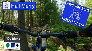
This trail has it all. Extremely well built trail that is generally low angle side hill flowy ripping with lots of berms and a few more difficult options and features as well. Short and oh so sweet.

Access Info

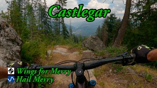
Up Merry Creek FSR 2km to the parking lot. To shuttle, continue up the road and take the next left fork. There will be a sign. Continue up the spur road until you reach the creek crossing. Park at the small pull out just before the creek or if your vehicle can take it continue past the creek and look for the trail head with sign on the left. For single track climbing head up the bottom of the trail and take the right fork at the bridge for Merry-Go-Round. Its a pretty good grunt with lots of tricky switchbacks to keep the climb interesting. Watch for riders coming down.

Local Trail Association

Recent Activity on Trail

Past Week
  • 3 rides
  • 8.4 km average
6 Months
  • 48 rides
  • 8.5 km avg distance
All
  • 663 rides
  • Last: Jun 16, 2026
c1c2c3c4
January
February
March
April
May
June
July
August
September
October
November
December
update trails status or condition

Hail Merry Trail Reports

statusdatedescription
Jun 8, 2026 @ 2:23pm (America/Vancouver)
Jun 8, 2026
May 10, 2026 @ 5:31pm (America/Vancouver)
May 10, 2026
broken bridge after the first section skinny.
Apr 28, 2026 @ 8:06pm (America/Vancouver)
Apr 28, 2026
Tree down about 60% of the way down right through one of the lower switchbacks
Apr 26, 2026 @ 3:02pm (America/Vancouver)
Apr 26, 2026
Tree down across trail, 75% downhill, just after the switchbacks
Mar 22, 2026 @ 5:18pm (America/Vancouver)
Mar 22, 2026
Trees have been cleared and running great!
more »
Status:
on Jun 8, 2026
Dry
Avg: 4.61 (38 votes)
Your vote: 0

view (3,536)
close
3D
Trail Conditions
  • Unknown
  • Snow Groomed
  • Snow Packed
  • Snow Covered
  • Snow Cover Partial
  • Freeze/thaw Cycle
  • Icy
  • Prevalent Mud
  • Wet
  • Variable
  • Ideal
  • Dry
  • Very Dry
Trail Flow (Ridden Direction)
Trailforks scans users ridelogs to determine the most popular direction each trail is ridden. A good flowing trail network will have most trails flowing in a single direction according to their intension.
The colour categories are based on what percentage of riders are riding a trail in its intended direction.
  • > 96%
  • > 90%
  • > 80%
  • > 70%
  • > 50%
  • < 50%
  • bi-directional trail
  • no data
Trail Last Ridden
Trailforks scans ridelogs to determine the last time a trail was ridden.
  • < 2 days
  • < 1 week
  • < 2 weeks
  • < 1 month
  • < 6 months
  • > 6 months
Trail Ridden Direction
The intended direction a trail should be ridden.
  • Downhill Only
  • Downhill Primary
  • Both Directions
  • Uphill Primary
  • Uphill Only
  • One Direction
Contribute Details
Colors indicate trail is missing specified detail.
  • Description
  • Photos
  • Description & Photos
  • Videos
Trail Popularity ?
Trailforks scans ridelogs to determine which trails are ridden the most in the last 9 months. Trails are compared with nearby trails in the same city region with a possible 25 colour shades. Think of this as a heatmap, more rides = more kinetic energy = warmer colors.
  • most popular
  • popular
  • less popular
  • not popular
ATV/ORV/OHV Filter
Max Vehicle Width
inches
US Cell Coverage
Legend
cell carrier legend

Radar Time
Activity Recordings
Trailforks uses anonymized public activity data. ?
Activity Recordings
Trailforks uses anonymized public activity data. ?
Personal Heatmap
Activity Types
all / none
Options
2
Date range month
Winter Trails
Warning A routing network for winter maps does not exist. Selecting trails using the winter trails layer has been disabled.
Missing Trails
Most Popular
Least Popular
Trails are colored based on popularity. The more popular a trail is, the more red. Less popular trails trend towards green.
Jump Magnitude Heatmap
Heatmap of where riders jump on trails. Zoom in to see individual jumps, click circles to view jump details.
BC Backroad Status

Service Road Atlas is a free to use, community-driven service for viewing and creating reports on the numerous back-country service roads around B.C. and Alberta.

map legend
Slope Aspect
Direction the slope faces
Flat N NE E SE S SW W NW
Trails Deemphasized
Trails are shown in grey.
disable
Only show trails with no bike usage.
Enable
Suggested Layers
Based on selected activity type

    Save the current map location and zoom level as your default home location whenever this page is loaded.

    Save
        Directions to hail-merry trailhead (49.288660, -117.686990)

        Photos

        12 more »
        207 |
        Oct 13, 2022 @ 4:46pm
        Oct 13, 2022
        314 |
        Jan 3, 2021 @ 4:08am
        Jan 3, 2021
        404 |
        Jan 3, 2021 @ 4:08am
        Jan 3, 2021
        265 |
        Jul 19, 2020 @ 3:57pm
        Jul 19, 2020

        Videos

        7 more »
        youtuber HAIL MERRY: Castlegar: Trail Review
        11:30 | 645 | Jun 25, 2022 , Castlegar
        youtuber Hail Merry - Castlegar, BC
        6:20 | 1242 | Oct 6, 2018 , Castlegar
        youtuber Wings for Merry and Hail Merry
        10:54 | 154 | Aug 10, 2023 , Castlegar
        HAIL MERRY TRAIL | MERRY CREEK | CASTLEGAR, BC
        10:21 | 724 | Mar 5, 2021 , Castlegar

        6 Reviews & Comments


        We hope you've been enjoying Trailforks!

        Create a FREE account to view trail comments and much more.

        • By zshipowickTF Pro & contributors
        • #4586 - 14,062 views

        Frequently Asked Questions About Hail Merry

        Where is Hail Merry located?
        Hail Merry is located in Merry Creek, Castlegar, British Columbia, Canada. It is part of the Merry Creek trail network. The trailhead is located at coordinates 49.28866, -117.68699.
        How hard is Hail Merry?
        Hail Merry is rated as Blue difficulty. The physical rating is Moderate. The average grade is 12.7%.
        What is the elevation gain for Hail Merry?
        The trail has 681 ft of elevation descent. The elevation ranges from 2,586 ft to 3,269 ft.
        Is Hail Merry a point to point trail?
        Yes, Hail Merry is a point to point trail. The direction is Downhill Only. The trail type is singletrack.

        Hit the Trail

        Open in App

        Get this trail on your phone instantly.
        open trail in app

        Download Trail

        Save to wishlist, Garmin & download.
        save the trail

        Find Related Routes

        Find routes and users activities that include this trail.
        find routes for this trail

        You must enter a description before submitting.