more stats
1.9 miles
Distance
1,851 ft
Climb
-22 ft
Descent
01:51:32
Avg time
1,829 ft
Altitude change
6,988 ft
Altitude min
8,817 ft
Altitude max
6,988 ft
Altitude start
8,816 ft
Altitude end
18.5%
Grade
-13.4%
Grade max
119.2%
Grade min
2 miles
Distance climb
515 ft
Distance down
43 ft
Distance flat
01:51:32
Avg time

Half Dome Details

  • Activities
    • Hike
    • Trail Running
  • Riding Area
    Yosemite National Park
    Yosemite, California
  • Difficulty Rating
  • Local Popularity
    100 in Hiking [+]
    • 100 in Trail Running
  • Global Ranking
    #1602 in Hiking [+]
    • #4740 in Trail Running
  • Hiking SAC Scale
    T4 Alpine Hiking
  • Trail Type
    Singletrack
  • Direction
    Both Directions
  • Physical Rating
    Hard
  • Dogs Allowed
    Yes

No community description for Half Dome trail has been added yet!

AI Generated Description

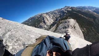
Half Dome is a 2 mile black diamond difficulty singletrack trail located near Yosemite California. This hike primary trail can be used both directions and has a hard overall physical rating. On average it takes 1 hour51 minutes to complete this trail.

Disclaimer

Permits to hike to the top of Half Dome are required seven days per week when the cables are up

Traditionally Indigenous Territory

Recent Activity on Trail

Past Week
  • 1 rides
  • 15 miles average
6 Months
  • 15 rides
  • 18 miles avg distance
All
  • 118 rides
  •  
c1c2c3c4
January
February
March
April
May
June
July
August
September
October
November
December
update trails status or condition

Half Dome Trail Reports

Status:
on Oct 18, 2023
Ideal
Avg: 5 (1 votes)
Your vote: 0

view (1,424)
close
3D
Trail Conditions
  • Unknown
  • Snow Groomed
  • Snow Packed
  • Snow Covered
  • Snow Cover Partial
  • Freeze/thaw Cycle
  • Icy
  • Prevalent Mud
  • Wet
  • Variable
  • Ideal
  • Dry
  • Very Dry
Trail Flow (Ridden Direction)
Trailforks scans users ridelogs to determine the most popular direction each trail is ridden. A good flowing trail network will have most trails flowing in a single direction according to their intension.
The colour categories are based on what percentage of riders are riding a trail in its intended direction.
  • > 96%
  • > 90%
  • > 80%
  • > 70%
  • > 50%
  • < 50%
  • bi-directional trail
  • no data
Trail Last Ridden
Trailforks scans ridelogs to determine the last time a trail was ridden.
  • < 2 days
  • < 1 week
  • < 2 weeks
  • < 1 month
  • < 6 months
  • > 6 months
Trail Ridden Direction
The intended direction a trail should be ridden.
  • Downhill Only
  • Downhill Primary
  • Both Directions
  • Uphill Primary
  • Uphill Only
  • One Direction
Contribute Details
Colors indicate trail is missing specified detail.
  • Description
  • Photos
  • Description & Photos
  • Videos
Trail Popularity ?
Trailforks scans ridelogs to determine which trails are ridden the most in the last 9 months. Trails are compared with nearby trails in the same city region with a possible 25 colour shades. Think of this as a heatmap, more rides = more kinetic energy = warmer colors.
  • most popular
  • popular
  • less popular
  • not popular
ATV/ORV/OHV Filter
Max Vehicle Width
inches
US Cell Coverage
Legend
cell carrier legend

Radar Time
Activity Recordings
Trailforks uses anonymized public activity data. ?
Activity Recordings
Trailforks uses anonymized public activity data. ?
Personal Heatmap
Activity Types
all / none
Options
2
Date range month
Winter Trails
Warning A routing network for winter maps does not exist. Selecting trails using the winter trails layer has been disabled.
Missing Trails
Most Popular
Least Popular
Trails are colored based on popularity. The more popular a trail is, the more red. Less popular trails trend towards green.
Jump Magnitude Heatmap
Heatmap of where riders jump on trails. Zoom in to see individual jumps, click circles to view jump details.
BC Backroad Status

Service Road Atlas is a free to use, community-driven service for viewing and creating reports on the numerous back-country service roads around B.C. and Alberta.

map legend
Slope Aspect
Direction the slope faces
Flat N NE E SE S SW W NW
Trails Deemphasized
Trails are shown in grey.
disable
Only show trails with no bike usage.
Enable
Suggested Layers
Based on selected activity type

    Save the current map location and zoom level as your default home location whenever this page is loaded.

    Save
        Directions to half-dome trailhead (37.745060, -119.512800)

        Photos

        10 more »
        76 |
        Jul 7, 2023 @ 5:23pm
        Jul 7, 2023
        116 |
        Jul 5, 2023 @ 10:40pm
        Jul 5, 2023
        101 |
        Jul 5, 2023 @ 10:40pm
        Jul 5, 2023
        93 |
        Jul 5, 2023 @ 10:40pm
        Jul 5, 2023

        Videos

        1 more »
        Half Dome August 2024
        22:16 | 125 | Aug 17, 2024 , Yosemite

        Articles

        Should Yosemite Close the Half Dome Cables? We Asked Alex Honnold.
        Jul 30, 2024 from outsideonline.com
        A recent tragedy on Yosemite’s iconic trail has revived a debate over safety. We asked veteran climbers Alex Honnold and Hans Florine to weigh in.
        Wanna Hike in California? These Are the 13 Most Stunning Trails.
        Jul 18, 2024 from outsideonline.com
        A longtime Golden State hiker reveals her dream list of the most beautiful, must-see routes in California

        Routes with this trail

        5.0 8 miles 4,983 ft 2
        Heavily traveled route more suited towards the experienced hiker. To go beyond the Sub Dome a permit is...
        42 miles 11,662 ft 10
        14 miles 5,282 ft 5

        1 Review & Comments


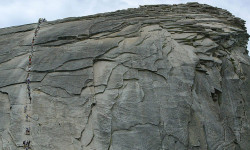
        We hope you've been enjoying Trailforks!

        Create a FREE account to view trail comments and much more.

        • By toddTF Pro Trailforks & contributors
        • #224777 - 1,789 views

        Frequently Asked Questions About Half Dome

        Where is Half Dome located?
        Half Dome is located in Yosemite National Park, Yosemite, California, United States. It is part of the Yosemite National Park trail network. The trailhead is located at coordinates 37.74506, -119.5128.
        How hard is Half Dome?
        Half Dome is rated as Black Diamond difficulty. The physical rating is Hard. The average grade is 18.5%.
        What is the elevation gain for Half Dome?
        Half Dome has 1,851 ft of elevation gain. The trail has 22 ft of elevation descent. The elevation ranges from 6,988 ft to 8,817 ft.
        Is Half Dome a point to point trail?
        Half Dome is not a point to point trail. The direction is Both Directions. The trail type is singletrack.

        Hit the Trail

        Open in App

        Get this trail on your phone instantly.
        open trail in app

        Download Trail

        Save to wishlist, Garmin & download.
        save the trail

        Find Related Routes

        Find routes and users activities that include this trail.
        find routes for this trail

        You must enter a description before submitting.