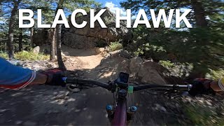
more stats
1.7 miles
Distance
-931 ft
Descent
00:12:27
Avg time
-931 ft
Altitude change
8,256 ft
Altitude min
9,187 ft
Altitude max
9,187 ft
Altitude start
8,258 ft
Altitude end
-10.5%
Grade
-49.3%
Grade max
-0.5%
Grade min
2 miles
Distance down
233 ft
Distance flat
00:12:27
Avg time

Hard Money Details

  • Activities
    • Mountain Bike
    • E-Bike
  • Riding Area
  • Difficulty Rating
  • Voted Difficulty
    Black Diamond (8 votes)
  • Local Popularity
    80 in Mountain Biking [+]
    • 85 in E-Biking
  • Global Ranking
    #415 in Mountain Biking [+]
    • #13191 in E-Biking
  • Blaze Color
  • Trail Type
    Singletrack
  • Direction
    Downhill Only
    Popular Direction Shown
  • Trail Visibility
    Always easy to follow
  • Dogs Allowed
    Yes
  • eBike Allowed
    Yes up to Class 1
  • TTFs on Trail
    Berm, Drop, Jump, Gap Jump, Rock Face, Rock Garden
  • Year Opened
    2021
  • Land Owner

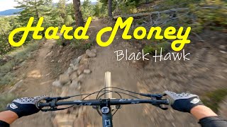
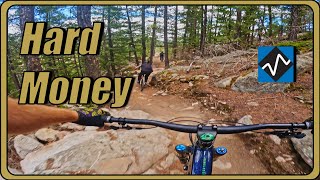
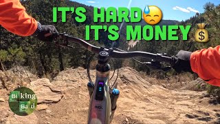
Originating from the saddle between the two Maryland Mountain peaks where all of the bike-only downhill trails start, Hard Money is a fast and furious blue-black trail that alternates between smooth rhythm sections with quite tall berms and quick rocky tech features, and throws in some substantial jump options to get some air time. Dropping almost 1,000 feet in 2-miles on a bike-only directional trail is sure to get your endorphins rushing and your face grinning. There are several easter eggs along the way so keep an eye out for the black level b-lines.

Access Info

Hard Money is downhill only and is accessed from Easy Money via Millsite Trail or the Historic Gilpin Tramway.

Local Trail Association
Traditionally Indigenous Territory

Recent Activity on Trail

Past Week
  • 5 rides
  • 10 miles average
6 Months
  • 135 rides
  • 12 miles avg distance
All
  • 1,001 rides
  • Last: Jun 18, 2026
c1c2c3c4
January
February
March
April
May
June
July
August
September
October
November
December
update trails status or condition

Hard Money Trail Reports

statusdatedescription
May 12, 2026 @ 11:17am (America/Denver)
May 12, 2026
Dry but ok to ride
May 3, 2026 @ 12:01pm (America/Denver)
May 3, 2026
Apr 4, 2026 @ 10:42pm (America/Denver)
Apr 4, 2026
Trail is extremely dry, some of the rock features are very sketchy braking wise with the amount of fine dry moondust on them. Near the halfway...
Dec 27, 2025 @ 10:13am (America/Denver)
Dec 27, 2025
Snow/ice in places, down tree across trail about halfway down, generally trail is in terrible condition
Aug 9, 2025 @ 12:44pm
Aug 9, 2025
more »
Status:
on May 12, 2026
Dry
Avg: 4.59 (34 votes)
Your vote: 0

view (8,943)
close
3D
Trail Conditions
  • Unknown
  • Snow Groomed
  • Snow Packed
  • Snow Covered
  • Snow Cover Partial
  • Freeze/thaw Cycle
  • Icy
  • Prevalent Mud
  • Wet
  • Variable
  • Ideal
  • Dry
  • Very Dry
Trail Flow (Ridden Direction)
Trailforks scans users ridelogs to determine the most popular direction each trail is ridden. A good flowing trail network will have most trails flowing in a single direction according to their intension.
The colour categories are based on what percentage of riders are riding a trail in its intended direction.
  • > 96%
  • > 90%
  • > 80%
  • > 70%
  • > 50%
  • < 50%
  • bi-directional trail
  • no data
Trail Last Ridden
Trailforks scans ridelogs to determine the last time a trail was ridden.
  • < 2 days
  • < 1 week
  • < 2 weeks
  • < 1 month
  • < 6 months
  • > 6 months
Trail Ridden Direction
The intended direction a trail should be ridden.
  • Downhill Only
  • Downhill Primary
  • Both Directions
  • Uphill Primary
  • Uphill Only
  • One Direction
Contribute Details
Colors indicate trail is missing specified detail.
  • Description
  • Photos
  • Description & Photos
  • Videos
Trail Popularity ?
Trailforks scans ridelogs to determine which trails are ridden the most in the last 9 months. Trails are compared with nearby trails in the same city region with a possible 25 colour shades. Think of this as a heatmap, more rides = more kinetic energy = warmer colors.
  • most popular
  • popular
  • less popular
  • not popular
ATV/ORV/OHV Filter
Max Vehicle Width
inches
US Cell Coverage
Legend
cell carrier legend

Radar Time
Activity Recordings
Trailforks uses anonymized public activity data. ?
Activity Recordings
Trailforks uses anonymized public activity data. ?
Personal Heatmap
Activity Types
all / none
Options
2
Date range month
Winter Trails
Warning A routing network for winter maps does not exist. Selecting trails using the winter trails layer has been disabled.
Missing Trails
Most Popular
Least Popular
Trails are colored based on popularity. The more popular a trail is, the more red. Less popular trails trend towards green.
Jump Magnitude Heatmap
Heatmap of where riders jump on trails. Zoom in to see individual jumps, click circles to view jump details.
BC Backroad Status

Service Road Atlas is a free to use, community-driven service for viewing and creating reports on the numerous back-country service roads around B.C. and Alberta.

map legend
Slope Aspect
Direction the slope faces
Flat N NE E SE S SW W NW
Trails Deemphasized
Trails are shown in grey.
disable
Only show trails with no bike usage.
Enable
Suggested Layers
Based on selected activity type

    Save the current map location and zoom level as your default home location whenever this page is loaded.

    Save
        Directions to hard-money trailhead (39.813100, -105.506260)

        Photos

        28 more »
        211 |
        Jan 15, 2025 @ 9:45pm
        Jan 15, 2025
        165 |
        Jan 15, 2025 @ 9:44pm
        Jan 15, 2025
        195 |
        Jan 15, 2025 @ 9:44pm
        Jan 15, 2025
        161 |
        Jan 15, 2025 @ 9:44pm
        Jan 15, 2025

        Videos

        7 more »
        Hard Money
        9:04 | 351 | Oct 19, 2024 , Black Hawk
        Black Hawk CO trails - Fast Money, Claim...
        14:57 | 123 | Sep 23, 2024 , Black Hawk
        Hard Money MTB Trail | Maryland Mountain
        7:54 | 494 | Jun 2, 2024 , Black Hawk
        Biking Bad - Mountain BikingHard Money|...
        10:07 | 214 | Feb 12, 2024 , Black Hawk

        Routes with this trail

        4.8 12 miles 1,901 ft 7 Loop
        If you want to check out all that Maryland Mountain has to offer, here's your ride! You'll do a bit of...
        3.7 5 miles 1,052 ft 2 Loop
        Want the fastest way to the goods? The intermediate-advanced bike-only downhill-only rowdy, bermy, jumpy...
        3.8 8 miles 1,395 ft 3 Loop
        This eight mile route gets you to not one, but TWO, bike optimized downhill trails! From the Hidden...

        17 Reviews & Comments


        We hope you've been enjoying Trailforks!

        Create a FREE account to view trail comments and much more.

        • By WendyBMATF Pro BMA & contributors
        • #436447 - 9,077 views

        Frequently Asked Questions About Hard Money

        Where is Hard Money located?
        Hard Money is located in Maryland Mountain Quartz Valley Park, Black Hawk, Colorado, United States. It is part of the Maryland Mountain Quartz Valley Park trail network. The trailhead is located at coordinates 39.8131, -105.50626.
        How hard is Hard Money?
        Hard Money is rated as Black Diamond difficulty. The average grade is 10.5%.
        What is the elevation gain for Hard Money?
        The trail has 931 ft of elevation descent. The elevation ranges from 8,256 ft to 9,187 ft.
        Is Hard Money a point to point trail?
        Yes, Hard Money is a point to point trail. The direction is Downhill Only. The trail type is singletrack.

        Hit the Trail

        Open in App

        Get this trail on your phone instantly.
        open trail in app

        Download Trail

        Save to wishlist, Garmin & download.
        save the trail

        Find Related Routes

        Find routes and users activities that include this trail.
        find routes for this trail

        You must enter a description before submitting.