more stats
1,795 ft
Distance
4 ft
Climb
-197 ft
Descent
00:02:37
Avg time
-194 ft
Altitude change
1,234 ft
Altitude min
1,431 ft
Altitude max
1,431 ft
Altitude start
1,237 ft
Altitude end
-10.8%
Grade
-42.7%
Grade max
3.8%
Grade min
105 ft
Distance climb
1,693 ft
Distance down
00:02:37
Avg time

Harzer Roller 1 Details

  • Activities
    • Mountain Bike
    • E-Bike
  • Riding Area
  • Ref Number
    #2
  • Difficulty Rating
  • Local Popularity
    75 in Mountain Biking [+]
    • 70 in E-Biking
  • Global Ranking
    #71081 in Mountain Biking [+]
    • #56684 in E-Biking
  • Trail Type
    Singletrack
  • Bike Type
    DH, AM
  • Direction
    Downhill Only
    Popular Direction Shown
  • Climb Difficulty
    Blue
  • Physical Rating
    Moderate
  • Trail Visibility
    Always easy to follow
  • eBike Allowed
    Yes up to Class 1
  • TTFs on Trail
    Berm
  • Ride in Rain
    Yes

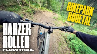
Erster Teil Harzer Roller. Flowig, wenig verblockt, mit vielen Kurven und ein paar vorher gut ersichtlichen Gegenanstiegen schraubt sich der Weg den Berg hinunter. Kleine Wellen laden zu Sprüngen ein. Der Weg endet in einer Brücke, wo man Mut und Skills haben sollte herunter zu rollen. Es gibt auch einen Chickenway rechts vorbei.

Bike Park

Recent Activity on Trail

Past Week
  • 0 rides
  •  
6 Months
  • 12 rides
  • 13 miles avg distance
All
  • 46 rides
  • Last: Jun 6, 2026
c1c2c3c4
January
February
March
April
May
June
July
August
September
October
November
December
update trails status or condition

Harzer Roller 1 Trail Reports

statusdatedescription
Mar 7, 2026 @ 11:11am (Europe/Berlin)
Mar 7, 2026
Mar 29, 2025 @ 12:18pm
Mar 29, 2025
Mar 16, 2024 @ 2:21am
Mar 16, 2024
Jul 2, 2023 @ 8:11am
Jul 2, 2023
Strecke ist wieder fein und wurde repariert. Danke!
Jun 27, 2023 @ 12:16am
Jun 27, 2023
Schäden durch den Regen am 23.06.2023. Viel Schotter auf dem Trail, rutschig.
more »
Status:
on Mar 7, 2026
Ideal
Avg: 3.99 (5 votes)
Your vote: 0

view (724)
close
3D
Trail Conditions
  • Unknown
  • Snow Groomed
  • Snow Packed
  • Snow Covered
  • Snow Cover Partial
  • Freeze/thaw Cycle
  • Icy
  • Prevalent Mud
  • Wet
  • Variable
  • Ideal
  • Dry
  • Very Dry
Trail Flow (Ridden Direction)
Trailforks scans users ridelogs to determine the most popular direction each trail is ridden. A good flowing trail network will have most trails flowing in a single direction according to their intension.
The colour categories are based on what percentage of riders are riding a trail in its intended direction.
  • > 96%
  • > 90%
  • > 80%
  • > 70%
  • > 50%
  • < 50%
  • bi-directional trail
  • no data
Trail Last Ridden
Trailforks scans ridelogs to determine the last time a trail was ridden.
  • < 2 days
  • < 1 week
  • < 2 weeks
  • < 1 month
  • < 6 months
  • > 6 months
Trail Ridden Direction
The intended direction a trail should be ridden.
  • Downhill Only
  • Downhill Primary
  • Both Directions
  • Uphill Primary
  • Uphill Only
  • One Direction
Contribute Details
Colors indicate trail is missing specified detail.
  • Description
  • Photos
  • Description & Photos
  • Videos
Trail Popularity ?
Trailforks scans ridelogs to determine which trails are ridden the most in the last 9 months. Trails are compared with nearby trails in the same city region with a possible 25 colour shades. Think of this as a heatmap, more rides = more kinetic energy = warmer colors.
  • most popular
  • popular
  • less popular
  • not popular
ATV/ORV/OHV Filter
Max Vehicle Width
inches
US Cell Coverage
Legend
cell carrier legend

Radar Time
Activity Recordings
Trailforks uses anonymized public activity data. ?
Activity Recordings
Trailforks uses anonymized public activity data. ?
Personal Heatmap
Activity Types
all / none
Options
2
Date range month
Winter Trails
Warning A routing network for winter maps does not exist. Selecting trails using the winter trails layer has been disabled.
Missing Trails
Most Popular
Least Popular
Trails are colored based on popularity. The more popular a trail is, the more red. Less popular trails trend towards green.
Jump Magnitude Heatmap
Heatmap of where riders jump on trails. Zoom in to see individual jumps, click circles to view jump details.
BC Backroad Status

Service Road Atlas is a free to use, community-driven service for viewing and creating reports on the numerous back-country service roads around B.C. and Alberta.

map legend
Slope Aspect
Direction the slope faces
Flat N NE E SE S SW W NW
Trails Deemphasized
Trails are shown in grey.
disable
Only show trails with no bike usage.
Enable
Suggested Layers
Based on selected activity type

    Save the current map location and zoom level as your default home location whenever this page is loaded.

    Save
        Directions to harzer-roller-1 trailhead (51.741960, 11.013740)

        Photos

        2 more »
        80 |
        May 3, 2023 @ 2:33pm
        May 3, 2023
        146 |
        Jan 6, 2020 @ 9:48am
        Jan 6, 2020

        Videos

        2 more »
        Harz MTB  | Bikepark Bodetal (Thale) –...
        4:22 | 129 | Jan 5, 2024 , Thale
        Bikepark Bodetal Harzer Roller RAW 2020 |...
        5:20 | 653 | Jun 23, 2020 , Thale

        3 Reviews & Comments


        We hope you've been enjoying Trailforks!

        Create a FREE account to view trail comments and much more.

        • By clausi87 & contributors
        • #229685 - 1,232 views

        Frequently Asked Questions About Harzer Roller 1

        Where is Harzer Roller 1 located?
        Harzer Roller 1 is located in Bikepark Bodetal (Rosstrappe), Thale, Germany. It is part of the Bikepark Bodetal (Rosstrappe) trail network. The trailhead is located at coordinates 51.74196, 11.01374.
        How hard is Harzer Roller 1?
        Harzer Roller 1 is rated as Blue difficulty. The physical rating is Moderate. The average grade is 10.8%. The climb difficulty is rated Blue.
        What is the elevation gain for Harzer Roller 1?
        Harzer Roller 1 has 1 m of elevation gain. The trail has 60 m of elevation descent. The elevation ranges from 376 m to 436 m.
        Is Harzer Roller 1 a point to point trail?
        Yes, Harzer Roller 1 is a point to point trail. The direction is Downhill Only. The trail type is singletrack.

        Hit the Trail

        Open in App

        Get this trail on your phone instantly.
        open trail in app

        Download Trail

        Save to wishlist, Garmin & download.
        save the trail

        Find Related Routes

        Find routes and users activities that include this trail.
        find routes for this trail

        You must enter a description before submitting.