more stats
1.9 miles
Distance
40 ft
Climb
-700 ft
Descent
00:18:02
Avg time
-659 ft
Altitude change
5,840 ft
Altitude min
6,499 ft
Altitude max
6,499 ft
Altitude start
5,840 ft
Altitude end
-6.7%
Grade
-39.6%
Grade max
29.9%
Grade min
794 ft
Distance climb
2 miles
Distance down
1,066 ft
Distance flat
00:18:02
Avg time

Hawks Glide Details

  • Activities
    • Mountain Bike
    • E-Bike
    • Hike
    • Trail Running
  • Riding Area
  • Difficulty Rating
  • Local Popularity
    100 in Mountain Biking [+]
    • 70 in Trail Running
    • 85 in Hiking
  • Global Ranking
    #1177 in Mountain Biking [+]
    • #90773 in Trail Running
    • #50218 in Hiking
  • Trail Exposure
    High Risk
  • Trail Type
    Singletrack
  • Bike Type
    AM, XC
  • Direction
    Downhill Only[+]
    Popular Direction Shown
    • Downhill Only for E-Biking
    • Both Directions for Trail Running
    • Both Directions for Hiking
  • Climb Difficulty
    Double Black Diamond
  • Physical Rating
    Moderate
  • Trail Visibility
    Always easy to follow
  • Season
    March - October
  • Dogs Allowed
    Yes
  • eBike Allowed
    Yes up to Class 1
  • TTFs on Trail
    Drop, Rock Face, Rock Garden, Other
  • Lighting
    No
  • Year Opened
    2022
  • Land Owner
    BLM

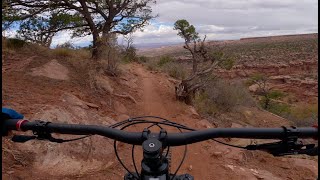
Hawks Glide is a trail in the Sand Flats Recreation Area, is a part of the Raptor Route and connects the Eagle Eye trail to the Falcon Flow trail.

Hawks Glide is recommended as a downhill route, riding from Eagle Eye, toward Falcon Flow.
The recommended climbing options are up Sand Flats Road, or up the Porcupine Rim Trail to Lazy Mans Road.
Hawks Glide starts about 200' down the Lazy Mans Road from the west end of Eagle Eye and continues mostly downhill to the Porcupine Rim Trail head, or Stock Tanks on Sand Flats Road.

The trail has similar terrain and technicality to Eagle Eye and Falcon Flow, Intermediate with advanced moments with the best views if you find time to stop and enjoy them. The trail is 18-24" wide single track mostly on softer soils, sometimes sand, with the occasional rough section and some of the area's most impressive rock work brought to you by our Moab Trail Team. @moabtrailmix

The bottom 800 feet of trail get more advanced, heed the black diamond warning sign at the top of the final descent. I recommend a scout, or slow roll down it as it's got some steep surprises in the last 800' of trail.

The top of the trail is at 6500 feet so winter conditions in this area often start in late October and can close the trail by early November. Winter conditions for this elevation means snow, melting to mud, then repeating and generally lasting until March. Please help protect our trails and check with a local shop for trail conditions.

Disclaimer

This trail is in Sand Flats Recreation Area and requires a fee upon entry or exit at pay booth.

Local Trail Association
Traditionally Indigenous Territory

Recent Activity on Trail

Past Week
  • 6 rides
  • 21 miles average
6 Months
  • 368 rides
  • 17 miles avg distance
All
  • 1,642 rides
  • Last: Jun 20, 2026
c1c2c3c4
January
February
March
April
May
June
July
August
September
October
November
December
Status:
on May 19, 2026
Ideal
Avg: 4.52 (25 votes)
Your vote: 0

view (6,384)
close
3D
Trail Conditions
  • Unknown
  • Snow Groomed
  • Snow Packed
  • Snow Covered
  • Snow Cover Partial
  • Freeze/thaw Cycle
  • Icy
  • Prevalent Mud
  • Wet
  • Variable
  • Ideal
  • Dry
  • Very Dry
Trail Flow (Ridden Direction)
Trailforks scans users ridelogs to determine the most popular direction each trail is ridden. A good flowing trail network will have most trails flowing in a single direction according to their intension.
The colour categories are based on what percentage of riders are riding a trail in its intended direction.
  • > 96%
  • > 90%
  • > 80%
  • > 70%
  • > 50%
  • < 50%
  • bi-directional trail
  • no data
Trail Last Ridden
Trailforks scans ridelogs to determine the last time a trail was ridden.
  • < 2 days
  • < 1 week
  • < 2 weeks
  • < 1 month
  • < 6 months
  • > 6 months
Trail Ridden Direction
The intended direction a trail should be ridden.
  • Downhill Only
  • Downhill Primary
  • Both Directions
  • Uphill Primary
  • Uphill Only
  • One Direction
Contribute Details
Colors indicate trail is missing specified detail.
  • Description
  • Photos
  • Description & Photos
  • Videos
Trail Popularity ?
Trailforks scans ridelogs to determine which trails are ridden the most in the last 9 months. Trails are compared with nearby trails in the same city region with a possible 25 colour shades. Think of this as a heatmap, more rides = more kinetic energy = warmer colors.
  • most popular
  • popular
  • less popular
  • not popular
ATV/ORV/OHV Filter
Max Vehicle Width
inches
US Cell Coverage
Legend
cell carrier legend

Radar Time
Activity Recordings
Trailforks uses anonymized public activity data. ?
Activity Recordings
Trailforks uses anonymized public activity data. ?
Personal Heatmap
Activity Types
all / none
Options
2
Date range month
Winter Trails
Warning A routing network for winter maps does not exist. Selecting trails using the winter trails layer has been disabled.
Missing Trails
Most Popular
Least Popular
Trails are colored based on popularity. The more popular a trail is, the more red. Less popular trails trend towards green.
Jump Magnitude Heatmap
Heatmap of where riders jump on trails. Zoom in to see individual jumps, click circles to view jump details.
BC Backroad Status

Service Road Atlas is a free to use, community-driven service for viewing and creating reports on the numerous back-country service roads around B.C. and Alberta.

map legend
Slope Aspect
Direction the slope faces
Flat N NE E SE S SW W NW
Trails Deemphasized
Trails are shown in grey.
disable
Only show trails with no bike usage.
Enable
Suggested Layers
Based on selected activity type

    Save the current map location and zoom level as your default home location whenever this page is loaded.

    Save
        Directions to hawks-glide trailhead (38.585180, -109.387730)

        Photos

        58 more »
        92 |
        Feb 16, 2026 @ 10:30am
        Feb 16, 2026
        77 |
        Feb 16, 2026 @ 10:30am
        Feb 16, 2026
        75 |
        Feb 16, 2026 @ 10:30am
        Feb 16, 2026
        149 |
        May 22, 2025 @ 2:34pm
        May 22, 2025

        Videos

        12 more »
        Hawks Glide at the Sand Flats Recreation Area...
        12:17 | 78 | Feb 14, 2026 , Moab
        The Raptor Route: Mountain Biking The Whole...
        26:10 | 44 | Oct 17, 2025 , Moab
        Hawks Glide
        10:45 | 57 | Apr 30, 2025 , Moab
        Hawks Glide - Moab, IT
        124 | Dec 2, 2024 , Moab

        Routes with this trail

        4.2 11 miles 436 ft 4 Loop
        Update of route to add the new trail. , , , , or the Raptor Route is an excellent downhill route that is...
        4.0 18 miles 2,863 ft 2 Point to Point
        , , , or the Raptor Route is an excellent downhill route that is great on its own or connect if off of the...
        5.0 27 miles 1,486 ft 13 Shuttled
        This is the whole enchilada /w , but instead of LPS, you take the raptor route! Slightly more intermediate...

        4 Reviews & Comments


        We hope you've been enjoying Trailforks!

        Create a FREE account to view trail comments and much more.

        • By GrandCountyTrailsTF Pro MTM & contributors
        • #585821 - 4,426 views

        Frequently Asked Questions About Hawks Glide

        Where is Hawks Glide located?
        Hawks Glide is located in Sand Flats Recreation Area, Moab, Utah, United States. It is part of the Sand Flats Recreation Area trail network. The trailhead is located at coordinates 38.58518, -109.38773.
        How hard is Hawks Glide?
        Hawks Glide is rated as Blue difficulty. The physical rating is Moderate. The average grade is 6.7%. The climb difficulty is rated Double Black Diamond.
        What is the elevation gain for Hawks Glide?
        Hawks Glide has 40 ft of elevation gain. The trail has 700 ft of elevation descent. The elevation ranges from 5,840 ft to 6,499 ft.
        Is Hawks Glide a point to point trail?
        Yes, Hawks Glide is a point to point trail. The direction is Downhill Only. The trail type is singletrack.

        Hit the Trail

        Open in App

        Get this trail on your phone instantly.
        open trail in app

        Download Trail

        Save to wishlist, Garmin & download.
        save the trail

        Find Related Routes

        Find routes and users activities that include this trail.
        find routes for this trail

        You must enter a description before submitting.