more stats
3,960 ft
Distance
35 ft
Climb
-340 ft
Descent
00:06:48
Avg time
-305 ft
Altitude change
2,010 ft
Altitude min
2,330 ft
Altitude max
2,315 ft
Altitude start
2,011 ft
Altitude end
-7.7%
Grade
-32.9%
Grade max
13.7%
Grade min
896 ft
Distance climb
2,930 ft
Distance down
138 ft
Distance flat
00:06:48
Avg time

Hell Boy part 1 Details

  • Activities
    • Mountain Bike
  • Riding Area
    Finale Outdoor Region
    Finale Ligure
  • Ref Number
    #361
  • AKA
    Hellboy P1
  • Difficulty Rating
  • Voted Difficulty
    Blue (4 votes)
  • Local Popularity
    90 in Mountain Biking
  • Global Ranking
    #2435 in Mountain Biking
  • Trail Type
    Singletrack
  • Bike Type
    AM, XC
  • Direction
    Downhill Only
    Popular Direction Shown
  • Climb Difficulty
    Green
  • Physical Rating
    Moderate
  • Trail Visibility
    Always easy to follow
  • Season
    All-year round
  • eBike Allowed
    Yes up to Class 1
  • Land Owner
    Finale Outdoor Region

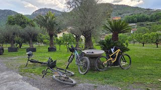
After the end of Hiroshima Mon Amour, the trail starts on the left at the Heli base.
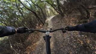
It starts with a couple of smooth turns and a drop-off; it continues quite nice and fast after that.

It features a 500m pedalling section in the middle and ends up on the gravel road that takes you to the Giogo di Giustenice.

source: ...
Access Info

Exit the E80 highway in Pietra Ligure. Keep going towards the sea and you'll get to Pietra Ligure. You'll then be able to drive toward the mountains in order to reach Val Maremola towns and trails.
Other option would be the E80 exit in Finale Ligure. Keep going towards the sea until you catch the SS1 Via Aurelia and move west until Pietra Ligure.

Disclaimer

Given its nature, the trail can change after weather happenings and season changes. Always pay attention.

Trail Supporters
Local Trail Association

Recent Activity on Trail

Past Week
  • 3 rides
  • 24 miles average
6 Months
  • 252 rides
  • 24 miles avg distance
All
  • 985 rides
  • Last: Jun 26, 2026
c1c2c3c4
January
February
March
April
May
June
July
August
September
October
November
December
Status:
on Jun 8, 2026
Ideal
Avg: 4.47 (48 votes)
Your vote: 0

view (5,443)
close
3D
Trail Conditions
  • Unknown
  • Snow Groomed
  • Snow Packed
  • Snow Covered
  • Snow Cover Partial
  • Freeze/thaw Cycle
  • Icy
  • Prevalent Mud
  • Wet
  • Variable
  • Ideal
  • Dry
  • Very Dry
Trail Flow (Ridden Direction)
Trailforks scans users ridelogs to determine the most popular direction each trail is ridden. A good flowing trail network will have most trails flowing in a single direction according to their intension.
The colour categories are based on what percentage of riders are riding a trail in its intended direction.
  • > 96%
  • > 90%
  • > 80%
  • > 70%
  • > 50%
  • < 50%
  • bi-directional trail
  • no data
Trail Last Ridden
Trailforks scans ridelogs to determine the last time a trail was ridden.
  • < 2 days
  • < 1 week
  • < 2 weeks
  • < 1 month
  • < 6 months
  • > 6 months
Trail Ridden Direction
The intended direction a trail should be ridden.
  • Downhill Only
  • Downhill Primary
  • Both Directions
  • Uphill Primary
  • Uphill Only
  • One Direction
Contribute Details
Colors indicate trail is missing specified detail.
  • Description
  • Photos
  • Description & Photos
  • Videos
Trail Popularity ?
Trailforks scans ridelogs to determine which trails are ridden the most in the last 9 months. Trails are compared with nearby trails in the same city region with a possible 25 colour shades. Think of this as a heatmap, more rides = more kinetic energy = warmer colors.
  • most popular
  • popular
  • less popular
  • not popular
ATV/ORV/OHV Filter
Max Vehicle Width
inches
US Cell Coverage
Legend
cell carrier legend

Radar Time
Activity Recordings
Trailforks uses anonymized public activity data. ?
Activity Recordings
Trailforks uses anonymized public activity data. ?
Personal Heatmap
Activity Types
all / none
Options
2
Date range month
Winter Trails
Warning A routing network for winter maps does not exist. Selecting trails using the winter trails layer has been disabled.
Missing Trails
Most Popular
Least Popular
Trails are colored based on popularity. The more popular a trail is, the more red. Less popular trails trend towards green.
Jump Magnitude Heatmap
Heatmap of where riders jump on trails. Zoom in to see individual jumps, click circles to view jump details.
BC Backroad Status

Service Road Atlas is a free to use, community-driven service for viewing and creating reports on the numerous back-country service roads around B.C. and Alberta.

map legend
Slope Aspect
Direction the slope faces
Flat N NE E SE S SW W NW
Trails Deemphasized
Trails are shown in grey.
disable
Only show trails with no bike usage.
Enable
Suggested Layers
Based on selected activity type

    Save the current map location and zoom level as your default home location whenever this page is loaded.

    Save
        Directions to hell-boy-part-1 trailhead (44.179870, 8.212020)

        Photos

        23 more »
        159 |
        Oct 20, 2022 @ 5:57am
        Oct 20, 2022
        135 |
        Apr 9, 2019 @ 2:07am
        Apr 9, 2019
        136 |
        Apr 9, 2019 @ 2:09am
        Apr 9, 2019
        146 |
        Apr 9, 2019 @ 2:10am
        Apr 9, 2019

        Videos

        7 more »
        Pietra Ligure  - Hiroshima Mon Amour 🔵...
        17:00 | 23 | May 1, 2026 , Finale Ligure
        Monte Carmo - Hell Boy
        4:36 | 61 | Nov 19, 2025 , Finale Ligure
        Enduro na najlepších trailoch Hiroshima a...
        17:50 | 68 | Aug 26, 2025 , Finale Ligure
        Pietra Ligure eMTBing - Trail Hell Boy Pt1
        5:12 | 203 | Aug 28, 2024 , Finale Ligure

        Trail Lists

        Routes with this trail

        5.0 15 miles 3,848 ft 10 Loop
        Partenza/rientro dal negozio HotBikes. Giro dedicato per E-bike Livello medio/alto Sosta intermedia presso...
        4.0 16 miles 4,283 ft 7
        Giro enduro nei pressi del Monte Carmo con partenza e ritorno da Bardineto, utilizzando alcuni tra i...
        41 miles 6,759 ft 11
        Uplift zu Forte, zweiter Uplift zu Base-Nato

        3 Reviews & Comments


        We hope you've been enjoying Trailforks!

        Create a FREE account to view trail comments and much more.

        Frequently Asked Questions About Hell Boy part 1

        Where is Hell Boy part 1 located?
        Hell Boy part 1 is located in Finale Outdoor Region, Finale Ligure, Italy. It is part of the Finale Outdoor Region trail network. The trailhead is located at coordinates 44.17987, 8.21202.
        How hard is Hell Boy part 1?
        Hell Boy part 1 is rated as Blue difficulty. The physical rating is Moderate. The average grade is 7.7%. The climb difficulty is rated Green.
        What is the elevation gain for Hell Boy part 1?
        Hell Boy part 1 has 11 m of elevation gain. The trail has 104 m of elevation descent. The elevation ranges from 613 m to 710 m.
        Is Hell Boy part 1 a point to point trail?
        Yes, Hell Boy part 1 is a point to point trail. The direction is Downhill Only. The trail type is singletrack.

        Hit the Trail

        Open in App

        Get this trail on your phone instantly.
        open trail in app

        Download Trail

        Save to wishlist, Garmin & download.
        save the trail

        Find Related Routes

        Find routes and users activities that include this trail.
        find routes for this trail

        You must enter a description before submitting.