more stats
3,881 ft
Distance
-419 ft
Descent
00:03:18
Avg time
-419 ft
Altitude change
3,915 ft
Altitude min
4,333 ft
Altitude max
4,333 ft
Altitude start
3,914 ft
Altitude end
-10.8%
Grade
-41.4%
Grade max
3.4%
Grade min
92 ft
Distance climb
3,789 ft
Distance down
00:03:18
Avg time

Hell's Bells Details

  • Activities
    • Mountain Bike
    • E-Bike
  • Riding Area
    Panorama Mountain Resort
    Panorama, British Columbia
  • Difficulty Rating
  • Local Popularity
    100 in Mountain Biking [+]
    • 100 in E-Biking
  • Global Ranking
    #29802 in Mountain Biking [+]
    • #5709 in E-Biking
  • Trail Type
    Singletrack
  • Bike Type
    DH
  • Direction
    Downhill Only
    Popular Direction Shown
  • eBike Allowed
    Yes up to Class 1
  • TTFs on Trail
    Jump
  • Land Owner

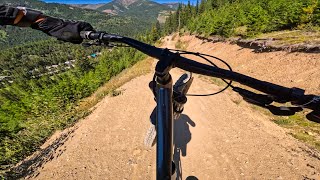
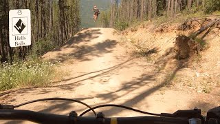
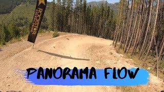
Panorama's advanced jump line which is the also the fastest route back from Mercy Me, Bazooka Joe etc. Most jumps range from 20-30 ft and include step downs, step ups, hips, and flat tabletops. All jumps are roll-able but jump skills are recommended. The first section is exposed to the wind so remember to check the wind flag and pre-ride, re-ride, freeride.

Bike Park

Recent Activity on Trail

Past Week
  • 0 rides
  •  
6 Months
  • 0 rides
  •  
All
  • 380 rides
  • Last: Sep 28, 2025
c1c2c3c4
January
February
March
April
May
June
July
August
September
October
November
December
update trails status or condition

Hell's Bells Trail Reports

Status:
on Sep 2, 2025
Ideal
Avg: 4.25 (26 votes)
Your vote: 0

view (6,256)
close
3D
Trail Conditions
  • Unknown
  • Snow Groomed
  • Snow Packed
  • Snow Covered
  • Snow Cover Partial
  • Freeze/thaw Cycle
  • Icy
  • Prevalent Mud
  • Wet
  • Variable
  • Ideal
  • Dry
  • Very Dry
Trail Flow (Ridden Direction)
Trailforks scans users ridelogs to determine the most popular direction each trail is ridden. A good flowing trail network will have most trails flowing in a single direction according to their intension.
The colour categories are based on what percentage of riders are riding a trail in its intended direction.
  • > 96%
  • > 90%
  • > 80%
  • > 70%
  • > 50%
  • < 50%
  • bi-directional trail
  • no data
Trail Last Ridden
Trailforks scans ridelogs to determine the last time a trail was ridden.
  • < 2 days
  • < 1 week
  • < 2 weeks
  • < 1 month
  • < 6 months
  • > 6 months
Trail Ridden Direction
The intended direction a trail should be ridden.
  • Downhill Only
  • Downhill Primary
  • Both Directions
  • Uphill Primary
  • Uphill Only
  • One Direction
Contribute Details
Colors indicate trail is missing specified detail.
  • Description
  • Photos
  • Description & Photos
  • Videos
Trail Popularity ?
Trailforks scans ridelogs to determine which trails are ridden the most in the last 9 months. Trails are compared with nearby trails in the same city region with a possible 25 colour shades. Think of this as a heatmap, more rides = more kinetic energy = warmer colors.
  • most popular
  • popular
  • less popular
  • not popular
ATV/ORV/OHV Filter
Max Vehicle Width
inches
US Cell Coverage
Legend
cell carrier legend

Radar Time
Activity Recordings
Trailforks uses anonymized public activity data. ?
Activity Recordings
Trailforks uses anonymized public activity data. ?
Personal Heatmap
Activity Types
all / none
Options
2
Date range month
Winter Trails
Warning A routing network for winter maps does not exist. Selecting trails using the winter trails layer has been disabled.
Missing Trails
Most Popular
Least Popular
Trails are colored based on popularity. The more popular a trail is, the more red. Less popular trails trend towards green.
Jump Magnitude Heatmap
Heatmap of where riders jump on trails. Zoom in to see individual jumps, click circles to view jump details.
BC Backroad Status

Service Road Atlas is a free to use, community-driven service for viewing and creating reports on the numerous back-country service roads around B.C. and Alberta.

map legend
Slope Aspect
Direction the slope faces
Flat N NE E SE S SW W NW
Trails Deemphasized
Trails are shown in grey.
disable
Only show trails with no bike usage.
Enable
Suggested Layers
Based on selected activity type

    Save the current map location and zoom level as your default home location whenever this page is loaded.

    Save
        Directions to hells-bells trailhead (50.445610, -116.241690)

        Photos

        15 more »
        536 |
        May 10, 2017 @ 8:43am
        May 10, 2017
        444 |
        Jun 23, 2016 @ 6:50am
        Jun 23, 2016
        40 |
        Sep 2, 2023 @ 2:57pm
        Sep 2, 2023
        251 |
        Jun 23, 2021 @ 2:58pm
        Jun 23, 2021

        Videos

        7 more »
        Full Speed Through Hell’s Bells! | 30ft Gaps...
        0:20 | 50 | Oct 8, 2025 , Panorama
        Panorama Bike Park - Hell’s bells
        2:10 | 677 | Aug 4, 2020 , Panorama
        Panorama Flow | Panorama Bike Park Part 1
        14:19 | 363 | Sep 27, 2019 , Panorama
        First Ride on the Firebird 29 // Panorama Bike...
        17:52 | 339 | Aug 14, 2019 , Panorama

        Routes with this trail

        15 miles 3,864 ft 9 Loop
        THE JACK PINE CHALLENGE...A beer worthy way to spend a day! The Challenge: New for Summer 2022, The Jack...
        20 miles 5,619 ft 16 Out & Back Race
        This is the route for [/L]. This route takes you from the resort base at 1188m up through the resort to...

        1 Review & Comments


        We hope you've been enjoying Trailforks!

        Create a FREE account to view trail comments and much more.

        • By Tekmisfit & contributors
        • #2451 - 7,683 views

        Frequently Asked Questions About Hell's Bells

        Where is Hell's Bells located?
        Hell's Bells is located in Panorama Mountain Resort, Panorama, British Columbia, Canada. It is part of the Panorama Mountain Resort trail network. The trailhead is located at coordinates 50.44561, -116.24169.
        How hard is Hell's Bells?
        Hell's Bells is rated as Black Diamond difficulty. The average grade is 10.8%.
        What is the elevation gain for Hell's Bells?
        The trail has 419 ft of elevation descent. The elevation ranges from 3,915 ft to 4,333 ft.
        Is Hell's Bells a point to point trail?
        Yes, Hell's Bells is a point to point trail. The direction is Downhill Only. The trail type is singletrack.

        Hit the Trail

        Open in App

        Get this trail on your phone instantly.
        open trail in app

        Download Trail

        Save to wishlist, Garmin & download.
        save the trail

        Find Related Routes

        Find routes and users activities that include this trail.
        find routes for this trail

        You must enter a description before submitting.