more stats
4,006 ft
Distance
-853 ft
Descent
00:07:36
Avg time
-853 ft
Altitude change
623 ft
Altitude min
1,476 ft
Altitude max
1,476 ft
Altitude start
623 ft
Altitude end
-21.3%
Grade
-53.5%
Grade max
-4.2%
Grade min
3,986 ft
Distance down
23 ft
Distance flat
00:07:36
Avg time

He-Man Details

  • Activities
    • Mountain Bike
    • E-Bike
  • Riding Area
  • Difficulty Rating
  • Voted Difficulty
    Blue (2 votes)
  • Global Ranking
    #52660 in Mountain Biking [+]
    • #103899 in E-Biking
  • Trail Type
    Singletrack
  • Bike Type
    AM
  • Direction
    Downhill Only
    Popular Direction Shown
  • Trail Visibility
    Always easy to follow
  • Dogs Allowed
    Yes
  • eBike Allowed
    Yes up to Class 1
  • TTFs on Trail
    Berm, Drop, Jump
  • Year Opened
    2020

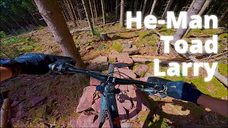
Super flowy and fast trail. Here you can practice your corner drift skills.
the berms are as big as necessary as small as possible. So there is always
enough support if you are brave enough to go in full speed.
There are some really small drops or mini jumps that are not mandatory, some of them
are mini huck to flat, but absolutely no big deal.
The trail is all about how fast can you go without sliding.

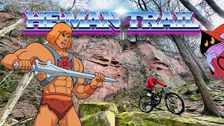
By the power of Grayskull, I have the Power – HE-Man

This trail is unsanctioned.

Trail Supporters

Recent Activity on Trail

Past Week
  • 0 rides
  •  
6 Months
  • 4 rides
  • 14 miles avg distance
All
  • 52 rides
  • Last: May 30, 2026
c1c2c3c4
January
February
March
April
May
June
July
August
September
October
November
December
update trails status or condition

He-Man Trail Reports

statusdatedescription
Apr 19, 2026 @ 3:41pm (Europe/Berlin)
Apr 19, 2026
Yesterday, I took a chance and rode the second section (after the stone roller), and it was totally fine. Below that, at the start of the third...
Apr 5, 2026 @ 12:39pm (Europe/Luxembourg)
Apr 5, 2026
Fully destroyed apart from the last part. Other parts are not rideable at all.
Mar 29, 2026 @ 7:22pm (Europe/Berlin)
Mar 29, 2026
Logging has advanced all the way to the top and the entry is now also destroyed. Only the last third of the trail (after crossing with...
Mar 29, 2026 @ 7:16pm (Europe/Berlin)
Mar 29, 2026
Logging has advanced all the way to the top and the entry is now also destroyed. Only the last third of the trail (after crossing with...
Mar 1, 2026 @ 1:58pm (Europe/Berlin)
Mar 1, 2026
There’s some forestry work going on in the area. Damaged part of the trail can be bypassed via Snakemountain.
more »
Status:
on Apr 19, 2026
Wet
Avg: 4.32 (7 votes)
Your vote: 0

view (0)
close
3D
Trail Conditions
  • Unknown
  • Snow Groomed
  • Snow Packed
  • Snow Covered
  • Snow Cover Partial
  • Freeze/thaw Cycle
  • Icy
  • Prevalent Mud
  • Wet
  • Variable
  • Ideal
  • Dry
  • Very Dry
Trail Flow (Ridden Direction)
Trailforks scans users ridelogs to determine the most popular direction each trail is ridden. A good flowing trail network will have most trails flowing in a single direction according to their intension.
The colour categories are based on what percentage of riders are riding a trail in its intended direction.
  • > 96%
  • > 90%
  • > 80%
  • > 70%
  • > 50%
  • < 50%
  • bi-directional trail
  • no data
Trail Last Ridden
Trailforks scans ridelogs to determine the last time a trail was ridden.
  • < 2 days
  • < 1 week
  • < 2 weeks
  • < 1 month
  • < 6 months
  • > 6 months
Trail Ridden Direction
The intended direction a trail should be ridden.
  • Downhill Only
  • Downhill Primary
  • Both Directions
  • Uphill Primary
  • Uphill Only
  • One Direction
Contribute Details
Colors indicate trail is missing specified detail.
  • Description
  • Photos
  • Description & Photos
  • Videos
Trail Popularity ?
Trailforks scans ridelogs to determine which trails are ridden the most in the last 9 months. Trails are compared with nearby trails in the same city region with a possible 25 colour shades. Think of this as a heatmap, more rides = more kinetic energy = warmer colors.
  • most popular
  • popular
  • less popular
  • not popular
ATV/ORV/OHV Filter
Max Vehicle Width
inches
US Cell Coverage
Legend
cell carrier legend

Radar Time
Activity Recordings
Trailforks uses anonymized public activity data. ?
Activity Recordings
Trailforks uses anonymized public activity data. ?
Personal Heatmap
Activity Types
all / none
Options
2
Date range month
Winter Trails
Warning A routing network for winter maps does not exist. Selecting trails using the winter trails layer has been disabled.
Missing Trails
Most Popular
Least Popular
Trails are colored based on popularity. The more popular a trail is, the more red. Less popular trails trend towards green.
Jump Magnitude Heatmap
Heatmap of where riders jump on trails. Zoom in to see individual jumps, click circles to view jump details.
BC Backroad Status

Service Road Atlas is a free to use, community-driven service for viewing and creating reports on the numerous back-country service roads around B.C. and Alberta.

map legend
Slope Aspect
Direction the slope faces
Flat N NE E SE S SW W NW
Trails Deemphasized
Trails are shown in grey.
disable
Only show trails with no bike usage.
Enable
Suggested Layers
Based on selected activity type

    Save the current map location and zoom level as your default home location whenever this page is loaded.

    Save
        Directions to heman trailhead (49.405850, 8.792810)

        Photos

        7 more »
        130 |
        Apr 6, 2023 @ 8:40am
        Apr 6, 2023
        117 |
        Apr 6, 2023 @ 8:40am
        Apr 6, 2023
        113 |
        Apr 6, 2023 @ 8:39am
        Apr 6, 2023
        100 |
        Apr 6, 2023 @ 8:39am
        Apr 6, 2023

        Videos

        3 more »
        He-Man, Toad, Larry
        12:32 | 84 | Aug 19, 2025 , Heidelberg
        HE-Man Trail MTB Enduro Tour Neckargemünd...
        16:35 | 292 | Apr 6, 2023 , Heidelberg
        youtuber Let's Ride MTB - Terra Incognita /...
        7:54 | 430 | Apr 16, 2022 , Heidelberg

        Reviews / Comments

        No reviews yet, be the first to write a review or ask a question.
        Use trail reports to comment on trail conditions.


        We hope you've been enjoying Trailforks!

        Create a FREE account to view trail comments and much more.

        Nearby Trails

        • #416628 - 1,805 views

        Frequently Asked Questions About He-Man

        Where is He-Man located?
        He-Man is located in Heidelberg, Germany. It is part of the Heidelberg trail network. The trailhead is located at coordinates 49.40585, 8.79281.
        How hard is He-Man?
        He-Man is rated as Red difficulty. The average grade is 21.3%.
        What is the elevation gain for He-Man?
        The trail has 260 m of elevation descent. The elevation ranges from 190 m to 450 m.
        Is He-Man a point to point trail?
        Yes, He-Man is a point to point trail. The direction is Downhill Only. The trail type is singletrack.

        Hit the Trail

        Open in App

        Get this trail on your phone instantly.
        open trail in app

        Download Trail

        Save to wishlist, Garmin & download.
        save the trail

        Find Related Routes

        Find routes and users activities that include this trail.
        find routes for this trail

        You must enter a description before submitting.