more stats
1.0 mile
Distance
-285 ft
Descent
00:09:51
Avg time
-287 ft
Altitude change
4,156 ft
Altitude min
4,444 ft
Altitude max
4,444 ft
Altitude start
4,157 ft
Altitude end
-5.3%
Grade
-22.2%
Grade max
1%
Grade min
4,501 ft
Distance down
896 ft
Distance flat
00:09:51
Avg time

Herkenham Details

  • Activities
    • Mountain Bike
    • Horse
    • Hike
    • Trail Running
  • Riding Area
    Carroll Canyon
    Sedona, Arizona
  • Ref Number
    #202
  • Difficulty Rating
  • Voted Difficulty
    Blue (3 votes)
  • Local Popularity
    85 in Mountain Biking [+]
    • 100 in Trail Running
    • 75 in Hiking
    • 5 in Horseback
  • Global Ranking
    #4560 in Mountain Biking [+]
    • #303 in Trail Running
    • #1844 in Hiking
  • Trail Type
    Singletrack
  • Direction
    Both Directions
  • Dogs Allowed
    Yes
  • eBike Allowed

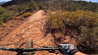
Intermediate 60% and advanced 40%, 1.4 mile MTB trail which is a bi-directional singletrack that is twisty up and down trail with a significant 300’ downhill component in the north to south direction. The trail tread is mostly packed dirt mixed with many rocky sections. The preferred direction to ride this trail is downhill, but there is a group of riders who love the challenging uphill direction.

Trail Supporters

  • USFS
    Land Manager
Local Trail Association

Recent Activity on Trail

Past Week
  • 1 rides
  • 4 miles average
6 Months
  • 125 rides
  • 12 miles avg distance
All
  • 900 rides
  • Last: Jun 22, 2026
c1c2c3c4
January
February
March
April
May
June
July
August
September
October
November
December
Status:
on Mar 25, 2026
Ideal
Avg: 4.08 (19 votes)
Your vote: 0

view (4,370)
close
3D
Trail Conditions
  • Unknown
  • Snow Groomed
  • Snow Packed
  • Snow Covered
  • Snow Cover Partial
  • Freeze/thaw Cycle
  • Icy
  • Prevalent Mud
  • Wet
  • Variable
  • Ideal
  • Dry
  • Very Dry
Trail Flow (Ridden Direction)
Trailforks scans users ridelogs to determine the most popular direction each trail is ridden. A good flowing trail network will have most trails flowing in a single direction according to their intension.
The colour categories are based on what percentage of riders are riding a trail in its intended direction.
  • > 96%
  • > 90%
  • > 80%
  • > 70%
  • > 50%
  • < 50%
  • bi-directional trail
  • no data
Trail Last Ridden
Trailforks scans ridelogs to determine the last time a trail was ridden.
  • < 2 days
  • < 1 week
  • < 2 weeks
  • < 1 month
  • < 6 months
  • > 6 months
Trail Ridden Direction
The intended direction a trail should be ridden.
  • Downhill Only
  • Downhill Primary
  • Both Directions
  • Uphill Primary
  • Uphill Only
  • One Direction
Contribute Details
Colors indicate trail is missing specified detail.
  • Description
  • Photos
  • Description & Photos
  • Videos
Trail Popularity ?
Trailforks scans ridelogs to determine which trails are ridden the most in the last 9 months. Trails are compared with nearby trails in the same city region with a possible 25 colour shades. Think of this as a heatmap, more rides = more kinetic energy = warmer colors.
  • most popular
  • popular
  • less popular
  • not popular
ATV/ORV/OHV Filter
Max Vehicle Width
inches
US Cell Coverage
Legend
cell carrier legend

Radar Time
Activity Recordings
Trailforks uses anonymized public activity data. ?
Activity Recordings
Trailforks uses anonymized public activity data. ?
Personal Heatmap
Activity Types
all / none
Options
2
Date range month
Winter Trails
Warning A routing network for winter maps does not exist. Selecting trails using the winter trails layer has been disabled.
Missing Trails
Most Popular
Least Popular
Trails are colored based on popularity. The more popular a trail is, the more red. Less popular trails trend towards green.
Jump Magnitude Heatmap
Heatmap of where riders jump on trails. Zoom in to see individual jumps, click circles to view jump details.
BC Backroad Status

Service Road Atlas is a free to use, community-driven service for viewing and creating reports on the numerous back-country service roads around B.C. and Alberta.

map legend
Slope Aspect
Direction the slope faces
Flat N NE E SE S SW W NW
Trails Deemphasized
Trails are shown in grey.
disable
Only show trails with no bike usage.
Enable
Suggested Layers
Based on selected activity type

    Save the current map location and zoom level as your default home location whenever this page is loaded.

    Save
        Directions to herkenham trailhead (34.847040, -111.828470)

        Photos

        2 more »
        115 |
        Oct 17, 2020 @ 6:28pm
        Oct 17, 2020
        151 |
        Oct 17, 2020 @ 6:27pm
        Oct 17, 2020

        Videos

        3 more »
        youtuber Are Lighter Wheels and Tires Better? Testing...
        14:44 | 748 | May 14, 2020 , Sedona
        Sedona MTB | Scorpion - Herkenham
        9:26 | 88 | Jan 22, 2025 , Sedona
        Herkenham
        6:38 | 662 | Jan 16, 2019 , Sedona

        Routes with this trail

        5.0 4 miles 561 ft 3
        4.0 11 miles 1,487 ft 9 Loop
        This loop is a butterfly, so you will end up climbing twice. However, that is well worth it for the trails...
        1.0 4 miles 538 ft 3 Loop
        This is a short loop that is great for most riders. Newer riders may find the climb up a bit challenging,...

        11 Reviews & Comments


        We hope you've been enjoying Trailforks!

        Create a FREE account to view trail comments and much more.

        • By toddTF Pro Trailforks & contributors
        • #14559 - 5,153 views

        Frequently Asked Questions About Herkenham

        Where is Herkenham located?
        Herkenham is located in Carroll Canyon, Sedona, Arizona, United States. It is part of the Carroll Canyon trail network. The trailhead is located at coordinates 34.84704, -111.82847.
        How hard is Herkenham?
        Herkenham is rated as Blue difficulty. The average grade is 5.3%.
        What is the elevation gain for Herkenham?
        The trail has 87 m of elevation descent. The elevation ranges from 1,267 m to 1,354 m.
        Is Herkenham a point to point trail?
        Herkenham is not a point to point trail. The direction is Both Directions. The trail type is singletrack.

        Hit the Trail

        Open in App

        Get this trail on your phone instantly.
        open trail in app

        Download Trail

        Save to wishlist, Garmin & download.
        save the trail

        Find Related Routes

        Find routes and users activities that include this trail.
        find routes for this trail

        You must enter a description before submitting.