more stats
1.4 miles
Distance
7 ft
Climb
-578 ft
Descent
00:09:09
Avg time
-571 ft
Altitude change
7,572 ft
Altitude min
8,143 ft
Altitude max
8,143 ft
Altitude start
7,572 ft
Altitude end
-7.8%
Grade
-35.2%
Grade max
8.6%
Grade min
348 ft
Distance climb
1 mile
Distance down
164 ft
Distance flat
00:09:09
Avg time

High Fives Details

  • Activities
    • Mountain Bike
    • E-Bike
    • Adaptive Bike
  • Riding Area
    Sky Tavern Bike Park
    Reno, Nevada
  • Difficulty Rating
  • Voted Difficulty
    Green (2 votes)
  • Local Popularity
    75 in Mountain Biking [+]
    • 100 in E-Biking
  • Global Ranking
    #6698 in Mountain Biking
  • Trail Exposure
    Normal
  • Trail Type
    Singletrack
  • Bike Type
    AM, XC, Adaptive MTB
  • Direction
    One Direction[+]
    Popular Direction Shown
    • One Direction for E-Biking
    • One Direction for Adaptive Biking
  • Climb Difficulty
    Green
  • Physical Rating
    Easy
  • Trail Visibility
    Always easy to follow
  • Season
    Apr - Oct
  • eBike Allowed
    Yes up to Class 1
  • TTFs on Trail
    Berm, Jump
  • Land Owner
    Sky Tavern 501c3 nonproft

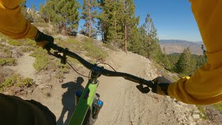
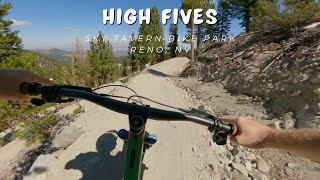
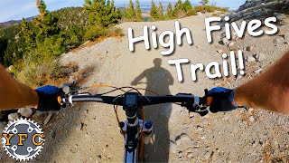
High Five is a purpose-built adaptive bike flow trail with berms, small jumps and features for riders of all abilities to enjoy. Sponsored by High Fives Foundation.

Access Info

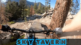
Access at Sky Tavern parking lot via Easy Up climb trail.

Adaptive Bike Info
aMTB Blue Rating: Intermediate features and steeper terrain.

Bike Park

Local Trail Association
  • trail association logo
  • Please consider joining or donating to the local trail association to support
    trail development & maintenance.
Traditionally Indigenous Territory

Recent Activity on Trail

Past Week
  • 7 hikes
  • 9 miles average
6 Months
  • 36 hikes
  • 8 miles avg distance
All
  • 347 hikes
  •  
c1c2c3c4
January
February
March
April
May
June
July
August
September
October
November
December
Status:
on May 30, 2026
Avg: 4.1 (4 votes)
Your vote: 0

view (2,205)
close
3D
Trail Conditions
  • Unknown
  • Snow Groomed
  • Snow Packed
  • Snow Covered
  • Snow Cover Partial
  • Freeze/thaw Cycle
  • Icy
  • Prevalent Mud
  • Wet
  • Variable
  • Ideal
  • Dry
  • Very Dry
Trail Flow (Ridden Direction)
Trailforks scans users ridelogs to determine the most popular direction each trail is ridden. A good flowing trail network will have most trails flowing in a single direction according to their intension.
The colour categories are based on what percentage of riders are riding a trail in its intended direction.
  • > 96%
  • > 90%
  • > 80%
  • > 70%
  • > 50%
  • < 50%
  • bi-directional trail
  • no data
Trail Last Ridden
Trailforks scans ridelogs to determine the last time a trail was ridden.
  • < 2 days
  • < 1 week
  • < 2 weeks
  • < 1 month
  • < 6 months
  • > 6 months
Trail Ridden Direction
The intended direction a trail should be ridden.
  • Downhill Only
  • Downhill Primary
  • Both Directions
  • Uphill Primary
  • Uphill Only
  • One Direction
Contribute Details
Colors indicate trail is missing specified detail.
  • Description
  • Photos
  • Description & Photos
  • Videos
Trail Popularity ?
Trailforks scans ridelogs to determine which trails are ridden the most in the last 9 months. Trails are compared with nearby trails in the same city region with a possible 25 colour shades. Think of this as a heatmap, more rides = more kinetic energy = warmer colors.
  • most popular
  • popular
  • less popular
  • not popular
ATV/ORV/OHV Filter
Max Vehicle Width
inches
US Cell Coverage
Legend
cell carrier legend

Radar Time
Activity Recordings
Trailforks uses anonymized public activity data. ?
Activity Recordings
Trailforks uses anonymized public activity data. ?
Personal Heatmap
Activity Types
all / none
Options
2
Date range month
Winter Trails
Warning A routing network for winter maps does not exist. Selecting trails using the winter trails layer has been disabled.
Missing Trails
Most Popular
Least Popular
Trails are colored based on popularity. The more popular a trail is, the more red. Less popular trails trend towards green.
Jump Magnitude Heatmap
Heatmap of where riders jump on trails. Zoom in to see individual jumps, click circles to view jump details.
BC Backroad Status

Service Road Atlas is a free to use, community-driven service for viewing and creating reports on the numerous back-country service roads around B.C. and Alberta.

map legend
Slope Aspect
Direction the slope faces
Flat N NE E SE S SW W NW
Trails Deemphasized
Trails are shown in grey.
disable
Only show trails with no bike usage.
Enable
Suggested Layers
Based on selected activity type

    Save the current map location and zoom level as your default home location whenever this page is loaded.

    Save
        Directions to high-fives trailhead (39.331170, -119.878130)

        Photos

        3 more »
        73 |
        Aug 11, 2025 @ 4:44pm
        Aug 11, 2025
        142 |
        Jul 19, 2023 @ 5:14pm
        Jul 19, 2023
        173 |
        Jul 19, 2023 @ 5:14pm
        Jul 19, 2023
        70 |
        Oct 3, 2024 @ 7:56pm
        Oct 3, 2024

        Videos

        5 more »
        youtuber Hi Fives Trail / Sky Tavern Bike Park | Reno,...
        4:47 | 77 | Nov 6, 2022 , Reno
        youtuber High Fives / Sky Tavern Bike Park | Reno, NV / MTB
        4:35 | 228 | Sep 9, 2024 , Reno
        youtuber High Fives Trail / Sky Tavern Bike Park
        5:58 | 248 | Oct 18, 2023 , Reno
        Lake Tahoe's Free Mountain Bike Park Is...
        20:05 | 106 | Apr 12, 2025 , Reno

        3 Reviews & Comments


        We hope you've been enjoying Trailforks!

        Create a FREE account to view trail comments and much more.

        • By Jdayton45TF Pro & contributors
        • #544941 - 2,365 views

        Frequently Asked Questions About High Fives

        Where is High Fives located?
        High Fives is located in Sky Tavern Bike Park, Reno, Nevada, United States. It is part of the Sky Tavern Bike Park trail network. The trailhead is located at coordinates 39.33117, -119.87813.
        How hard is High Fives?
        High Fives is rated as Blue difficulty. The physical rating is Easy. The average grade is 7.8%. The climb difficulty is rated Green.
        What is the elevation gain for High Fives?
        High Fives has 2 m of elevation gain. The trail has 176 m of elevation descent. The elevation ranges from 2,308 m to 2,482 m.
        Is High Fives a point to point trail?
        Yes, High Fives is a point to point trail. The direction is One Direction. The trail type is singletrack.

        Hit the Trail

        Open in App

        Get this trail on your phone instantly.
        open trail in app

        Download Trail

        Save to wishlist, Garmin & download.
        save the trail

        Find Related Routes

        Find routes and users activities that include this trail.
        find routes for this trail

        You must enter a description before submitting.