more stats
1,186 ft
Distance
-120 ft
Descent
00:04:33
Avg time
-120 ft
Altitude change
2,556 ft
Altitude min
2,676 ft
Altitude max
2,676 ft
Altitude start
2,556 ft
Altitude end
-10.129%
Grade
-20.812%
Grade max
0.607%
Grade min
1,131 ft
Distance down
54 ft
Distance flat
00:04:33
Avg time

High Roller Details

  • Activities
    • Mountain Bike
    • E-Bike
    • Hike
    • Trail Running
  • Riding Area
    Three Blind Mice
    Penticton, British Columbia
  • Difficulty Rating
  • Local Popularity
    90 in Mountain Biking [+]
    • 85 in E-Biking
    • 55 in Trail Running
    • 75 in Hiking
  • Global Ranking
    #42113 in Mountain Biking [+]
    • #33531 in E-Biking
    • #108298 in Trail Running
    • #77193 in Hiking
  • Trail Type
    Singletrack
  • Bike Type
    AM
  • Direction
    Downhill Only
    Popular Direction Shown
  • Physical Rating
    Easy
  • Season
    April-November
  • Dogs Allowed
    Yes
  • eBike Allowed
    Yes up to Class 1
  • TTFs on Trail
    Drop, Rock Face

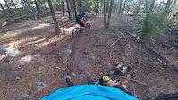
An amazing connector between Fred/Mule Deer to Drops A Lot. Has 2 nice rock rolls run out nice and straight.

Access Info

Come in from Fred/Mule Deer area; go down (North-East) a bit from that intersection and there will be a fain turn off on your left after coming down the built-up Right Hander around the rock (you'll know)

Local Trail Association

Recent Activity on Trail

Past Week
  • 1 rides
  • 11 miles average
6 Months
  • 26 rides
  • 12 miles avg distance
All
  • 355 rides
  • Last: Jun 18, 2026
c1c2c3c4
January
February
March
April
May
June
July
August
September
October
November
December
update trails status or condition

High Roller Trail Reports

statusdatedescription
Apr 1, 2026 @ 6:10pm (America/Vancouver)
Apr 1, 2026
Rides pretty good, not too dry not too wet, just right!
Jul 31, 2025 @ 9:24am
Jul 31, 2025
May 4, 2025 @ 6:22pm
May 4, 2025
Tree down near the start, tried to remove solo but may need a group and saw
May 4, 2025 @ 6:22pm
May 4, 2025
Apr 6, 2025 @ 2:36pm
Apr 6, 2025
reporter
more »
Status:
on Apr 1, 2026
Ideal
Avg: 4.46 (12 votes)
Your vote: 0

view (2,476)
close
3D
Trail Conditions
  • Unknown
  • Snow Groomed
  • Snow Packed
  • Snow Covered
  • Snow Cover Partial
  • Freeze/thaw Cycle
  • Icy
  • Prevalent Mud
  • Wet
  • Variable
  • Ideal
  • Dry
  • Very Dry
Trail Flow (Ridden Direction)
Trailforks scans users ridelogs to determine the most popular direction each trail is ridden. A good flowing trail network will have most trails flowing in a single direction according to their intension.
The colour categories are based on what percentage of riders are riding a trail in its intended direction.
  • > 96%
  • > 90%
  • > 80%
  • > 70%
  • > 50%
  • < 50%
  • bi-directional trail
  • no data
Trail Last Ridden
Trailforks scans ridelogs to determine the last time a trail was ridden.
  • < 2 days
  • < 1 week
  • < 2 weeks
  • < 1 month
  • < 6 months
  • > 6 months
Trail Ridden Direction
The intended direction a trail should be ridden.
  • Downhill Only
  • Downhill Primary
  • Both Directions
  • Uphill Primary
  • Uphill Only
  • One Direction
Contribute Details
Colors indicate trail is missing specified detail.
  • Description
  • Photos
  • Description & Photos
  • Videos
Trail Popularity ?
Trailforks scans ridelogs to determine which trails are ridden the most in the last 9 months. Trails are compared with nearby trails in the same city region with a possible 25 colour shades. Think of this as a heatmap, more rides = more kinetic energy = warmer colors.
  • most popular
  • popular
  • less popular
  • not popular
ATV/ORV/OHV Filter
Max Vehicle Width
inches
US Cell Coverage
Legend
cell carrier legend

Radar Time
Activity Recordings
Trailforks uses anonymized public activity data. ?
Activity Recordings
Trailforks uses anonymized public activity data. ?
Personal Heatmap
Activity Types
all / none
Options
2
Date range month
Winter Trails
Warning A routing network for winter maps does not exist. Selecting trails using the winter trails layer has been disabled.
Missing Trails
Most Popular
Least Popular
Trails are colored based on popularity. The more popular a trail is, the more red. Less popular trails trend towards green.
Jump Magnitude Heatmap
Heatmap of where riders jump on trails. Zoom in to see individual jumps, click circles to view jump details.
BC Backroad Status

Service Road Atlas is a free to use, community-driven service for viewing and creating reports on the numerous back-country service roads around B.C. and Alberta.

map legend
Slope Aspect
Direction the slope faces
Flat N NE E SE S SW W NW
Trails Deemphasized
Trails are shown in grey.
disable
Only show trails with no bike usage.
Enable
Suggested Layers
Based on selected activity type

    Save the current map location and zoom level as your default home location whenever this page is loaded.

    Save
        Directions to high-roller-19092 trailhead (49.569410, -119.550060)

        Photos

        13 more »
        61 |
        Aug 4, 2024 @ 8:58pm
        Aug 4, 2024
        68 |
        Aug 3, 2024 @ 1:31pm
        Aug 3, 2024
        97 |
        May 22, 2022 @ 1:28pm
        May 22, 2022
        165 |
        Apr 9, 2021 @ 9:28pm
        Apr 9, 2021

        Videos

        4 more »
        youtuber High Roller | Three Blind Mice | Penticton
        0:15 | 1013 | Jun 6, 2019 , Penticton
        Golden hour in wine country
        5:05 | 87 | Apr 25, 2025 , Penticton
        High Roller with BCpov
        818 | May 2, 2017 , Penticton
        High Roller in November
        0:32 | 126 | Nov 8, 2021 , Penticton

        Routes with this trail

        9 miles 1,666 ft 11
        One of our best and most well-ridden loops. Be sure to catch your breath and take in the view before you...
        87 miles 16,565 ft 66 Loop
        Almost everything in the mice
        2.0 8 miles 823 ft 5 Shuttled
        NIce mice tour with some fo the best decents on the lower mice.

        Trail Products

        1 Review & Comments


        We hope you've been enjoying Trailforks!

        Create a FREE account to view trail comments and much more.

        Nearby Trails

        • By smokeTF Pro Simpcw & contributors
        • #19092 - 5,352 views

        Frequently Asked Questions About High Roller

        Where is High Roller located?
        High Roller is located in Three Blind Mice, Penticton, British Columbia, Canada. It is part of the Three Blind Mice trail network. The trailhead is located at coordinates 49.56941, -119.55006.
        How hard is High Roller?
        High Roller is rated as Black Diamond difficulty. The physical rating is Easy. The average grade is 10.129%.
        What is the elevation gain for High Roller?
        The trail has 37 m of elevation descent. The elevation ranges from 779 m to 816 m.
        Is High Roller a point to point trail?
        Yes, High Roller is a point to point trail. The direction is Downhill Only. The trail type is singletrack.

        Hit the Trail

        Open in App

        Get this trail on your phone instantly.
        open trail in app

        Download Trail

        Save to wishlist, Garmin & download.
        save the trail

        Find Related Routes

        Find routes and users activities that include this trail.
        find routes for this trail

        You must enter a description before submitting.