more stats
4.0 miles
Distance
1,099 ft
Climb
-937 ft
Descent
01:06:42
Avg time
162 ft
Altitude change
4,672 ft
Altitude min
5,280 ft
Altitude max
4,672 ft
Altitude start
4,833 ft
Altitude end
0.8%
Grade
-63.5%
Grade max
50.5%
Grade min
2 miles
Distance climb
2 miles
Distance down
659 ft
Distance flat
01:06:42
Avg time

Highline Details

  • Activities
    • Mountain Bike
    • Winter Fat Bike
    • Hike
    • Trail Running
  • Riding Area
  • Difficulty Rating
  • Voted Difficulty
    Blue (2 votes)
  • Local Popularity
    65 in Mountain Biking [+]
    • 85 in Trail Running
    • 5 in Hiking
  • Global Ranking
    #37007 in Mountain Biking [+]
    • #3085 in Trail Running
    • #121403 in Hiking
  • Trail Type
    Singletrack
  • Bike Type
    AM, XC, Fat
  • Direction
    Both Directions
    Popular Direction Shown
  • Climb Difficulty
    Black Diamond
  • Physical Rating
    Hard
  • Dogs Allowed
    Yes
  • eBike Allowed
  • Land Owner
    Alberta Parks

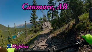
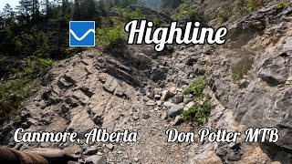
Built by Jeff Eamon [Alberta Parks], Parks seasonal workers and loads of volunteers [notably Friends of Kananaskis Country], the Highline trail is a machine-built, hand-finished singletrack trail on the lower slopes of Grassi and Ha Ling Peaks.

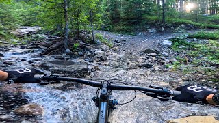
Highline is a fun trail with some tech challenges in the form of boulders and rocky drainage sections that must be crossed. Once you're up the climbs, the trail rolls along the sidehill, with shorter ups and downs to plow through. The soil is rocky, the switchbacks steep, and fitness is a good thing to have. The West Connector is the easiest climb, and things get a bit tougher as you head east. Climbing Riders of Rohan is not great. Loose gravel, steep, lots of downhill traffic, etc.

Highline is a multi-use trail, so expect to see hikers, runners, dog-walkers, bears, deer, etc.

Access Info

The SE trailhead is at the corner of Three Sisters Blvd and Hubman Landing. Parking is very limited here - don't park in front of somebody's driveway, and clean up after yourself. Many people access the trail from Quarry Lake parking lot, and ride up the West Connector, or ride the powerline trail to the East Connector and loop back from there.

Recent Activity on Trail

Past Week
  • 4 rides
  • 17 miles average
6 Months
  • 9 rides
  • 15 miles avg distance
All
  • 219 rides
  • Last: Jun 16, 2026
c1c2c3c4
January
February
March
April
May
June
July
August
September
October
November
December
update trails status or condition

Highline Trail Reports

statusdatedescription
May 24, 2026 @ 6:35pm (America/Edmonton)
May 24, 2026
The slide path at km 1.4 is still full of debris, but it's possible to get across.
May 9, 2026 @ 2:59pm (America/Edmonton)
May 9, 2026
Rideable but there is a rock slip above the bridge that is only going to get worse if we get more rain.
Aug 15, 2025 @ 6:03pm
Aug 15, 2025
Jul 29, 2025 @ 11:57am
Jul 29, 2025
Tree down
Jun 14, 2025 @ 9:40am
Jun 14, 2025
more »
Status:
on May 24, 2026
Ideal
Avg: 4.14 (23 votes)
Your vote: 0

view (1,590)
close
3D
Trail Conditions
  • Unknown
  • Snow Groomed
  • Snow Packed
  • Snow Covered
  • Snow Cover Partial
  • Freeze/thaw Cycle
  • Icy
  • Prevalent Mud
  • Wet
  • Variable
  • Ideal
  • Dry
  • Very Dry
Trail Flow (Ridden Direction)
Trailforks scans users ridelogs to determine the most popular direction each trail is ridden. A good flowing trail network will have most trails flowing in a single direction according to their intension.
The colour categories are based on what percentage of riders are riding a trail in its intended direction.
  • > 96%
  • > 90%
  • > 80%
  • > 70%
  • > 50%
  • < 50%
  • bi-directional trail
  • no data
Trail Last Ridden
Trailforks scans ridelogs to determine the last time a trail was ridden.
  • < 2 days
  • < 1 week
  • < 2 weeks
  • < 1 month
  • < 6 months
  • > 6 months
Trail Ridden Direction
The intended direction a trail should be ridden.
  • Downhill Only
  • Downhill Primary
  • Both Directions
  • Uphill Primary
  • Uphill Only
  • One Direction
Contribute Details
Colors indicate trail is missing specified detail.
  • Description
  • Photos
  • Description & Photos
  • Videos
Trail Popularity ?
Trailforks scans ridelogs to determine which trails are ridden the most in the last 9 months. Trails are compared with nearby trails in the same city region with a possible 25 colour shades. Think of this as a heatmap, more rides = more kinetic energy = warmer colors.
  • most popular
  • popular
  • less popular
  • not popular
ATV/ORV/OHV Filter
Max Vehicle Width
inches
US Cell Coverage
Legend
cell carrier legend

Radar Time
Activity Recordings
Trailforks uses anonymized public activity data. ?
Activity Recordings
Trailforks uses anonymized public activity data. ?
Personal Heatmap
Activity Types
all / none
Options
2
Date range month
Winter Trails
Warning A routing network for winter maps does not exist. Selecting trails using the winter trails layer has been disabled.
Missing Trails
Most Popular
Least Popular
Trails are colored based on popularity. The more popular a trail is, the more red. Less popular trails trend towards green.
Jump Magnitude Heatmap
Heatmap of where riders jump on trails. Zoom in to see individual jumps, click circles to view jump details.
BC Backroad Status

Service Road Atlas is a free to use, community-driven service for viewing and creating reports on the numerous back-country service roads around B.C. and Alberta.

map legend
Slope Aspect
Direction the slope faces
Flat N NE E SE S SW W NW
Trails Deemphasized
Trails are shown in grey.
disable
Only show trails with no bike usage.
Enable
Suggested Layers
Based on selected activity type

    Save the current map location and zoom level as your default home location whenever this page is loaded.

    Save
        Directions to highline-10011 trailhead (51.074860, -115.391530)

        Photos

        89 more »
        81 |
        May 1, 2024 @ 3:55pm
        May 1, 2024
        61 |
        Apr 29, 2024 @ 9:10pm
        Apr 29, 2024
        57 |
        Apr 29, 2024 @ 9:10pm
        Apr 29, 2024
        114 |
        Apr 29, 2024 @ 9:09pm
        Apr 29, 2024

        Videos

        10 more »
        youtuber This scenic MTB trail in Canmore, AB is worth...
        14:31 | 130 | Aug 8, 2025 , Canmore
        Highline in Canmore, BC
        50:14 | 54 | Nov 8, 2025 , Canmore
        Highline Trail: Rocks, Climbs & Flow
        6:04 | 81 | Jul 2, 2025 , Canmore
        Fat Biking End-of-Season April 2025
        18:12 | 64 | Apr 16, 2025 , Canmore

        Routes with this trail

        5.0 14 miles 2,864 ft 8
        The newest Pedal for Pints loop, starting at Quarry Lake parking lot, going up Highline for a full west to...
        5.0 30 miles 4,689 ft 48
        CNC Start - Highline - Guy Lafleur - Deadmans to refuel - Reverse - - CNC Hot Lap
        9 miles 1,461 ft 3 Loop
        Canmore - Highline/Powerline/Loki loop Start at Hubman Landing & Three Sisters Blvd entrance Ride West...

        9 Reviews & Comments


        We hope you've been enjoying Trailforks!

        Create a FREE account to view trail comments and much more.

        • By megandTF Pro & contributors
        • #10011 - 33,067 views

        Frequently Asked Questions About Highline

        Where is Highline located?
        Highline is located in Bow Valley Wildland Provincial Park, Canmore, Alberta, Canada. It is part of the Bow Valley Wildland Provincial Park trail network. The trailhead is located at coordinates 51.07486, -115.39153.
        How hard is Highline?
        Highline is rated as Blue difficulty. The physical rating is Hard. The average grade is 0.8%. The climb difficulty is rated Black Diamond.
        What is the elevation gain for Highline?
        Highline has 1,099 ft of elevation gain. The trail has 937 ft of elevation descent. The elevation ranges from 4,672 ft to 5,280 ft.
        Is Highline a point to point trail?
        Highline is not a point to point trail. The direction is Both Directions. The trail type is singletrack.

        Hit the Trail

        Open in App

        Get this trail on your phone instantly.
        open trail in app

        Download Trail

        Save to wishlist, Garmin & download.
        save the trail

        Find Related Routes

        Find routes and users activities that include this trail.
        find routes for this trail

        You must enter a description before submitting.