more stats
3.1 miles
Distance
300 ft
Climb
-674 ft
Descent
01:01:59
Avg time
-374 ft
Altitude change
4,084 ft
Altitude min
4,644 ft
Altitude max
4,474 ft
Altitude start
4,101 ft
Altitude end
-2.3%
Grade
-51.6%
Grade max
28.8%
Grade min
1 mile
Distance climb
2 miles
Distance down
1,673 ft
Distance flat
01:01:59
Avg time

Hiline Details

  • Activities
    • Mountain Bike
    • Hike
    • Trail Running
  • Riding Area
    Cathedral
    Village Of Oak Creek, Arizona
  • Difficulty Rating
  • Voted Difficulty
    Double Black Diamond (16 votes)
  • Local Popularity
    90 in Mountain Biking [+]
    • 75 in Trail Running
    • 85 in Hiking
  • Global Ranking
    #140 in Mountain Biking [+]
    • #63 in Trail Running
    • #434 in Hiking
  • Trail Type
    Singletrack
  • Direction
    Downhill Only
    Popular Direction Shown
  • Climb Difficulty
    Double Black Diamond
  • Physical Rating
    Hard
  • Dogs Allowed
    Yes
  • eBike Allowed

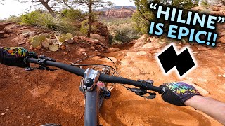
Beginner 20%, intermediate 40%, advanced 20% and expert 20%, 2.62 mile very technical MTB trail which is a bi-directional singletrack, that is up and down with about 400 yards of technical exposed and really steep sections a lesser skilled rider will have to walk. The trail tread is mostly packed dirt mixed with some rocks. There are also sections of slickrock that is fun to ride by all levels of riders. The preferred direction is southeast to northwest and the trail is a great connector for several other fun loops.

Disclaimer

Equestrians Restricted

Trail Supporters
Local Trail Association

Recent Activity on Trail

Past Week
  • 3 rides
  • 10 miles average
6 Months
  • 269 rides
  • 16 miles avg distance
All
  • 2,176 rides
  • Last: Jun 18, 2026
c1c2c3c4
January
February
March
April
May
June
July
August
September
October
November
December
Status:
on Apr 3, 2026
Ideal
Avg: 4.53 (163 votes)
Your vote: 0

view (13,760)
close
3D
Trail Conditions
  • Unknown
  • Snow Groomed
  • Snow Packed
  • Snow Covered
  • Snow Cover Partial
  • Freeze/thaw Cycle
  • Icy
  • Prevalent Mud
  • Wet
  • Variable
  • Ideal
  • Dry
  • Very Dry
Trail Flow (Ridden Direction)
Trailforks scans users ridelogs to determine the most popular direction each trail is ridden. A good flowing trail network will have most trails flowing in a single direction according to their intension.
The colour categories are based on what percentage of riders are riding a trail in its intended direction.
  • > 96%
  • > 90%
  • > 80%
  • > 70%
  • > 50%
  • < 50%
  • bi-directional trail
  • no data
Trail Last Ridden
Trailforks scans ridelogs to determine the last time a trail was ridden.
  • < 2 days
  • < 1 week
  • < 2 weeks
  • < 1 month
  • < 6 months
  • > 6 months
Trail Ridden Direction
The intended direction a trail should be ridden.
  • Downhill Only
  • Downhill Primary
  • Both Directions
  • Uphill Primary
  • Uphill Only
  • One Direction
Contribute Details
Colors indicate trail is missing specified detail.
  • Description
  • Photos
  • Description & Photos
  • Videos
Trail Popularity ?
Trailforks scans ridelogs to determine which trails are ridden the most in the last 9 months. Trails are compared with nearby trails in the same city region with a possible 25 colour shades. Think of this as a heatmap, more rides = more kinetic energy = warmer colors.
  • most popular
  • popular
  • less popular
  • not popular
ATV/ORV/OHV Filter
Max Vehicle Width
inches
US Cell Coverage
Legend
cell carrier legend

Radar Time
Activity Recordings
Trailforks uses anonymized public activity data. ?
Activity Recordings
Trailforks uses anonymized public activity data. ?
Personal Heatmap
Activity Types
all / none
Options
2
Date range month
Winter Trails
Warning A routing network for winter maps does not exist. Selecting trails using the winter trails layer has been disabled.
Missing Trails
Most Popular
Least Popular
Trails are colored based on popularity. The more popular a trail is, the more red. Less popular trails trend towards green.
Jump Magnitude Heatmap
Heatmap of where riders jump on trails. Zoom in to see individual jumps, click circles to view jump details.
BC Backroad Status

Service Road Atlas is a free to use, community-driven service for viewing and creating reports on the numerous back-country service roads around B.C. and Alberta.

map legend
Slope Aspect
Direction the slope faces
Flat N NE E SE S SW W NW
Trails Deemphasized
Trails are shown in grey.
disable
Only show trails with no bike usage.
Enable
Suggested Layers
Based on selected activity type

    Save the current map location and zoom level as your default home location whenever this page is loaded.

    Save
        Directions to hiline trailhead (34.804640, -111.771290)

        Photos

        278 more »
        3,595 |
        Jan 24, 2018 @ 12:12am
        Jan 24, 2018
        2,402 |
        Apr 13, 2017 @ 10:33am
        Apr 13, 2017
        1,053 |
        Jan 1, 2018 @ 8:59pm
        Jan 1, 2018
        1,447 |
        May 3, 2017 @ 11:49am
        May 3, 2017

        Videos

        85 more »
        youtuber Riding the MOST GNARLY TRAILS and CRAZY HUCK...
        28:21 | 1674 | May 18, 2023 , Village Of Oak Creek
        youtuber He Crashes Hard In Sedona! ( Hiline and Hogs...
        15:34 | 1174 | Mar 9, 2022 , Village Of Oak Creek
        youtuber Why Ride Arizona? - Eminent Onset 29er - South...
        16:37 | 1256 | Mar 31, 2020 , Village Of Oak Creek
        youtuber The Hardest and Steepest MTB Line in Sedona...
        31:33 | 1591 | Mar 9, 2022 , Village Of Oak Creek

        Trail Lists

        Routes with this trail

        4.4 9 miles 958 ft 2 Loop
        This is my favorite ride. I do it every 2nd or 3rd ride. The highlight is Hiline. Starts with a sometimes...
        5.0 37 miles 5,341 ft 20 Loop
        Triple H has a new sibling. This ride combines four of the most technical trails in Sedona: Hardline,...
        4.0 10 miles 1,317 ft 12 Loop
        is a "must do" bucket list ride for the experienced rider. Even if you have to walk the Double Black...

        49 Reviews & Comments


        We hope you've been enjoying Trailforks!

        Create a FREE account to view trail comments and much more.

        Nearby Trails

        • By toddTF Pro Trailforks & contributors
        • #14583 - 62,342 views

        Frequently Asked Questions About Hiline

        Where is Hiline located?
        Hiline is located in Cathedral, Village Of Oak Creek, Arizona, United States. It is part of the Cathedral trail network. The trailhead is located at coordinates 34.80464, -111.77129.
        How hard is Hiline?
        Hiline is rated as Double Black Diamond difficulty. The physical rating is Hard. The average grade is 2.3%. The climb difficulty is rated Double Black Diamond.
        What is the elevation gain for Hiline?
        Hiline has 300 ft of elevation gain. The trail has 674 ft of elevation descent. The elevation ranges from 4,084 ft to 4,644 ft.
        Is Hiline a point to point trail?
        Yes, Hiline is a point to point trail. The direction is Downhill Only. The trail type is singletrack.

        Hit the Trail

        Open in App

        Get this trail on your phone instantly.
        open trail in app

        Download Trail

        Save to wishlist, Garmin & download.
        save the trail

        Find Related Routes

        Find routes and users activities that include this trail.
        find routes for this trail

        You must enter a description before submitting.