more stats
1.3 miles
Distance
39 ft
Climb
-1,285 ft
Descent
00:18:28
Avg time
-1,247 ft
Altitude change
4,752 ft
Altitude min
6,001 ft
Altitude max
6,001 ft
Altitude start
4,754 ft
Altitude end
-18%
Grade
-88.4%
Grade max
21.5%
Grade min
492 ft
Distance climb
1 mile
Distance down
272 ft
Distance flat
00:18:28
Avg time

Hill Bill Details

  • Activities
    • Mountain Bike
  • Riding Area
    Bike Serfaus-Fiss-Ladis
    Serfaus-Fiss-Ladis
  • Ref Number
    #21
  • Difficulty Rating
  • Local Popularity
    60 in Mountain Biking
  • Global Ranking
    #46070 in Mountain Biking
  • Trail Type
    Singletrack
  • Direction
    Downhill Only
  • Land Owner

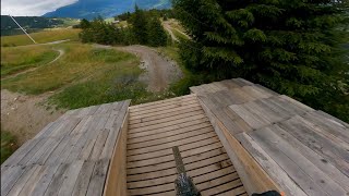
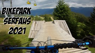
On the Hill Bill, things really get down to the wire – certainly not a place for weak nerves. In addition to the downhill course in the bike park, the Hill Bill is another black line, which means the top level in terms of difficulty. On a length of 2,450 metres, you have to prove your skills and at the same time test your limits.

Access Info

Waldbahn top station

Bike Park

Recent Activity on Trail

Past Week
  • 4 rides
  • 29 miles average
6 Months
  • 4 rides
  • 29 miles avg distance
All
  • 204 rides
  • Last: Jun 20, 2026
c1c2c3c4
January
February
March
April
May
June
July
August
September
October
November
December
update trails status or condition

Hill Bill Trail Reports

statusdatedescription
Jan 10, 2026 @ 9:24am (Europe/Vienna)
Jan 10, 2026
Closed, Winterbetrieb bzw. Wintersperre. Vrsl. Öffnung der Bikepark-Saison 2026: 4. - 7. Juni 2026 (Pre-Opening)
Jul 19, 2024 @ 6:14am
Jul 19, 2024
Partly closed off, upper and lower sections are open
Aug 9, 2022 @ 12:58am
Aug 9, 2022
Sep 26, 2021 @ 12:51am
Sep 26, 2021
Sep 19, 2021 @ 12:26am
Sep 19, 2021
more »
Status:
on Jan 10, 2026
Avg: 4.41 (18 votes)
Your vote: 0

view (1,888)
close
3D
Trail Conditions
  • Unknown
  • Snow Groomed
  • Snow Packed
  • Snow Covered
  • Snow Cover Partial
  • Freeze/thaw Cycle
  • Icy
  • Prevalent Mud
  • Wet
  • Variable
  • Ideal
  • Dry
  • Very Dry
Trail Flow (Ridden Direction)
Trailforks scans users ridelogs to determine the most popular direction each trail is ridden. A good flowing trail network will have most trails flowing in a single direction according to their intension.
The colour categories are based on what percentage of riders are riding a trail in its intended direction.
  • > 96%
  • > 90%
  • > 80%
  • > 70%
  • > 50%
  • < 50%
  • bi-directional trail
  • no data
Trail Last Ridden
Trailforks scans ridelogs to determine the last time a trail was ridden.
  • < 2 days
  • < 1 week
  • < 2 weeks
  • < 1 month
  • < 6 months
  • > 6 months
Trail Ridden Direction
The intended direction a trail should be ridden.
  • Downhill Only
  • Downhill Primary
  • Both Directions
  • Uphill Primary
  • Uphill Only
  • One Direction
Contribute Details
Colors indicate trail is missing specified detail.
  • Description
  • Photos
  • Description & Photos
  • Videos
Trail Popularity ?
Trailforks scans ridelogs to determine which trails are ridden the most in the last 9 months. Trails are compared with nearby trails in the same city region with a possible 25 colour shades. Think of this as a heatmap, more rides = more kinetic energy = warmer colors.
  • most popular
  • popular
  • less popular
  • not popular
ATV/ORV/OHV Filter
Max Vehicle Width
inches
US Cell Coverage
Legend
cell carrier legend

Radar Time
Activity Recordings
Trailforks uses anonymized public activity data. ?
Activity Recordings
Trailforks uses anonymized public activity data. ?
Personal Heatmap
Activity Types
all / none
Options
2
Date range month
Winter Trails
Warning A routing network for winter maps does not exist. Selecting trails using the winter trails layer has been disabled.
Missing Trails
Most Popular
Least Popular
Trails are colored based on popularity. The more popular a trail is, the more red. Less popular trails trend towards green.
Jump Magnitude Heatmap
Heatmap of where riders jump on trails. Zoom in to see individual jumps, click circles to view jump details.
BC Backroad Status

Service Road Atlas is a free to use, community-driven service for viewing and creating reports on the numerous back-country service roads around B.C. and Alberta.

map legend
Slope Aspect
Direction the slope faces
Flat N NE E SE S SW W NW
Trails Deemphasized
Trails are shown in grey.
disable
Only show trails with no bike usage.
Enable
Suggested Layers
Based on selected activity type

    Save the current map location and zoom level as your default home location whenever this page is loaded.

    Save
        Directions to hill-bill trailhead (47.051700, 10.591820)

        Photos

        5 more »
        256 |
        Jul 30, 2018 @ 2:18am
        Jul 30, 2018
        219 |
        Jul 30, 2018 @ 2:18am
        Jul 30, 2018
        554 |
        Apr 24, 2018 @ 3:32am
        Apr 24, 2018
        508 |
        Apr 24, 2018 @ 3:28am
        Apr 24, 2018

        Videos

        10 more »
        youtuber Hill Bill - Bike Park Serfaus-Fiss-Ladis
        6:20 | 369 | Sep 15, 2023 , Serfaus-Fiss-Ladis
        Streckenvorschau Downhill ÖM 2026  - Bikepark...
        4:07 | 0 | Jun 18, 2026 , Serfaus-Fiss-Ladis
        youtuber Bikepark Serfaus-Fiss-Ladis GoPro Raw |...
        10:38 | 84 | Sep 1, 2024 , Serfaus-Fiss-Ladis
        Mein bester Bikepark Tag 2021|Bikepark Serfaus...
        19:25 | 179 | Nov 13, 2021 , Serfaus-Fiss-Ladis

        1 Review & Comments


        We hope you've been enjoying Trailforks!

        Create a FREE account to view trail comments and much more.

        Frequently Asked Questions About Hill Bill

        Where is Hill Bill located?
        Hill Bill is located in Bike Serfaus-Fiss-Ladis, Serfaus-Fiss-Ladis, Austria. It is part of the Bike Serfaus-Fiss-Ladis trail network. The trailhead is located at coordinates 47.0517, 10.59182.
        How hard is Hill Bill?
        Hill Bill is rated as Black difficulty. The average grade is 18%.
        What is the elevation gain for Hill Bill?
        Hill Bill has 39 ft of elevation gain. The trail has 1,285 ft of elevation descent. The elevation ranges from 4,752 ft to 6,001 ft.
        Is Hill Bill a point to point trail?
        Yes, Hill Bill is a point to point trail. The direction is Downhill Only. The trail type is singletrack.

        Hit the Trail

        Open in App

        Get this trail on your phone instantly.
        open trail in app

        Download Trail

        Save to wishlist, Garmin & download.
        save the trail

        Find Related Routes

        Find routes and users activities that include this trail.
        find routes for this trail

        You must enter a description before submitting.