more stats
2.3 miles
Distance
601 ft
Climb
-19 ft
Descent
00:43:10
Avg time
582 ft
Altitude change
2,926 ft
Altitude min
3,509 ft
Altitude max
2,926 ft
Altitude start
3,507 ft
Altitude end
4.8%
Grade
-5%
Grade max
41.5%
Grade min
2 miles
Distance climb
1,850 ft
Distance down
1,371 ft
Distance flat
00:43:10
Avg time

Historic Babylon Details

  • Activities
    • Mountain Bike
    • E-Bike
    • Hike
    • Trail Running
  • Riding Area
  • Difficulty Rating
  • Local Popularity
    30 in Mountain Biking [+]
    • 30 in E-Biking
    • 5 in Trail Running
    • 45 in Hiking
  • Global Ranking
    #129512 in Mountain Biking [+]
    • #90270 in E-Biking
    • #129205 in Trail Running
    • #102388 in Hiking
  • Trail Type
    Singletrack
  • Direction
    Both Directions
    Popular Direction Shown
  • Climb Difficulty
    Black Diamond
  • Physical Rating
    Hard
  • Dogs Allowed
    Yes
  • eBike Allowed
    Yes up to Class 1

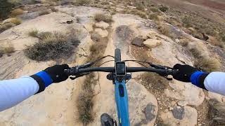
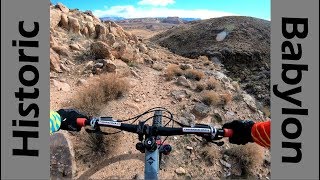
A trail that is somewhere between Zen and the Scout Trails with a side of Antiques Roadshow. Come ride these trails for some arduous climbs and techy descents, see and enjoy the topographic artwork drawn through the erosive hand of the Virgin River over millions of years, experience early human art through seeing the ancient petroglyphs drawn along the trail. This trail is ideal for those who love to wander and don't feel lost while doing so.

There are 3-6 potential river crossings in the first portion of the canyon, depending on the line you choose. Recommended loop is up Babylon and down Purgatory. Petroglyphs are near the river crossings area. There are the remains of an abandoned mine nearby as well, however the shaft was filled with cement and barricaded in 2000. There are some portions of loose rock/rubble going up Babylon that may require walking your bike as it is easy to spin out. These areas are a minority along the trail and do add some technical fun. Certainly not a trail for the faint at heart.

Trail Supporters
  • BLM
    BLM
    Land Manager
Traditionally Indigenous Territory

Recent Activity on Trail

Past Week
  • 0 rides
  •  
6 Months
  • 5 rides
  • 7 miles avg distance
All
  • 20 rides
  • Last: Jun 12, 2026
c1c2c3c4
January
February
March
April
May
June
July
August
September
October
November
December
update trails status or condition

Historic Babylon Trail Reports

statusdatedescription
Dec 15, 2023 @ 10:54am
Dec 15, 2023
Shrubs/brush in the creek crossings section need to be trimmed back.
May 6, 2023 @ 8:10am
May 6, 2023
Up Babylon, down Purgatory notes from mid-April. First, if you're thinking this is going to be like many of the rides in the St. George area,...
Mar 1, 2021 @ 1:23pm
Mar 1, 2021
Feb 9, 2021 @ 4:30pm
Feb 9, 2021
Trail was in great shape easy to follow. Really liked this wish it was longer.
Dec 28, 2020 @ 11:23am
Dec 28, 2020
Fun trail. No one was there so we had it to ourselves. ???? This trail is not heavily used so there is brush overgrowth in places and lots of...
more »
Status:
on Dec 15, 2023
Ideal
Avg: 3.11 (11 votes)
Your vote: 0

view (100)
close
3D
Trail Conditions
  • Unknown
  • Snow Groomed
  • Snow Packed
  • Snow Covered
  • Snow Cover Partial
  • Freeze/thaw Cycle
  • Icy
  • Prevalent Mud
  • Wet
  • Variable
  • Ideal
  • Dry
  • Very Dry
Trail Flow (Ridden Direction)
Trailforks scans users ridelogs to determine the most popular direction each trail is ridden. A good flowing trail network will have most trails flowing in a single direction according to their intension.
The colour categories are based on what percentage of riders are riding a trail in its intended direction.
  • > 96%
  • > 90%
  • > 80%
  • > 70%
  • > 50%
  • < 50%
  • bi-directional trail
  • no data
Trail Last Ridden
Trailforks scans ridelogs to determine the last time a trail was ridden.
  • < 2 days
  • < 1 week
  • < 2 weeks
  • < 1 month
  • < 6 months
  • > 6 months
Trail Ridden Direction
The intended direction a trail should be ridden.
  • Downhill Only
  • Downhill Primary
  • Both Directions
  • Uphill Primary
  • Uphill Only
  • One Direction
Contribute Details
Colors indicate trail is missing specified detail.
  • Description
  • Photos
  • Description & Photos
  • Videos
Trail Popularity ?
Trailforks scans ridelogs to determine which trails are ridden the most in the last 9 months. Trails are compared with nearby trails in the same city region with a possible 25 colour shades. Think of this as a heatmap, more rides = more kinetic energy = warmer colors.
  • most popular
  • popular
  • less popular
  • not popular
ATV/ORV/OHV Filter
Max Vehicle Width
inches
US Cell Coverage
Legend
cell carrier legend

Radar Time
Activity Recordings
Trailforks uses anonymized public activity data. ?
Activity Recordings
Trailforks uses anonymized public activity data. ?
Personal Heatmap
Activity Types
all / none
Options
2
Date range month
Winter Trails
Warning A routing network for winter maps does not exist. Selecting trails using the winter trails layer has been disabled.
Missing Trails
Most Popular
Least Popular
Trails are colored based on popularity. The more popular a trail is, the more red. Less popular trails trend towards green.
Jump Magnitude Heatmap
Heatmap of where riders jump on trails. Zoom in to see individual jumps, click circles to view jump details.
BC Backroad Status

Service Road Atlas is a free to use, community-driven service for viewing and creating reports on the numerous back-country service roads around B.C. and Alberta.

map legend
Slope Aspect
Direction the slope faces
Flat N NE E SE S SW W NW
Trails Deemphasized
Trails are shown in grey.
disable
Only show trails with no bike usage.
Enable
Suggested Layers
Based on selected activity type

    Save the current map location and zoom level as your default home location whenever this page is loaded.

    Save
        Directions to historic-babylon trailhead (37.201860, -113.348800)

        Photos

        9 more »
        78 |
        Jan 6, 2024 @ 5:40pm
        Jan 6, 2024
        99 |
        Dec 4, 2021 @ 8:31am
        Dec 4, 2021
        101 |
        Dec 4, 2021 @ 8:13am
        Dec 4, 2021
        81 |
        Dec 4, 2021 @ 8:05am
        Dec 4, 2021

        Videos

        3 more »
        MTB Loop From HELL? - Riding The Historic...
        17:23 | 125 | Jan 20, 2024 , Hurricane
        Historic Babylon and Little Purgatory...
        8:15 | 638 | Mar 24, 2021 , Hurricane
        youtuber Riding Through History on Historic Babylon!
        11:38 | 1014 | Feb 4, 2019 , Hurricane

        8 Reviews & Comments


        We hope you've been enjoying Trailforks!

        Create a FREE account to view trail comments and much more.

        • By toddTF Pro Trailforks & contributors
        • #9214 - 3,414 views

        Frequently Asked Questions About Historic Babylon

        Where is Historic Babylon located?
        Historic Babylon is located in Red Cliffs BLM National Conservation Area-Sand Cove Unit, Hurricane, Utah, United States. It is part of the Red Cliffs BLM National Conservation Area-Sand Cove Unit trail network. The trailhead is located at coordinates 37.20186, -113.3488.
        How hard is Historic Babylon?
        Historic Babylon is rated as Black Diamond difficulty. The physical rating is Hard. The average grade is 4.8%. The climb difficulty is rated Black Diamond.
        What is the elevation gain for Historic Babylon?
        Historic Babylon has 601 ft of elevation gain. The trail has 19 ft of elevation descent. The elevation ranges from 2,926 ft to 3,509 ft.
        Is Historic Babylon a point to point trail?
        Historic Babylon is not a point to point trail. The direction is Both Directions. The trail type is singletrack.

        Hit the Trail

        Open in App

        Get this trail on your phone instantly.
        open trail in app

        Download Trail

        Save to wishlist, Garmin & download.
        save the trail

        Find Related Routes

        Find routes and users activities that include this trail.
        find routes for this trail

        You must enter a description before submitting.