more stats
1.7 miles
Distance
255 ft
Climb
-244 ft
Descent
00:24:53
Avg time
9 ft
Altitude change
4,301 ft
Altitude min
4,407 ft
Altitude max
4,330 ft
Altitude start
4,341 ft
Altitude end
0.1%
Grade
-24.8%
Grade max
21.9%
Grade min
3,127 ft
Distance climb
3,071 ft
Distance down
2,651 ft
Distance flat
00:24:53
Avg time

Hogwash Details

  • Activities
    • Mountain Bike
    • Hike
    • Trail Running
  • Riding Area
    Broken Arrow
    Sedona, Arizona
  • Difficulty Rating
  • Voted Difficulty
    Black Diamond (3 votes)
  • Local Popularity
    80 in Mountain Biking [+]
    • 75 in Trail Running
    • 75 in Hiking
  • Global Ranking
    #2010 in Mountain Biking [+]
    • #20972 in Trail Running
    • #37921 in Hiking
  • Trail Type
    Singletrack
  • Direction
    Both Directions
    Popular In Reverse
  • Dogs Allowed
    Yes
  • eBike Allowed

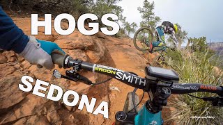
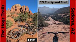
Beginner 30%, intermediate 50 % and advanced 20% and expert %, mile MTB trail which is a bi-directional singletrack (double track) that is twisty, buffed, dry washes,with up and down trail with some technical sections exposure and slickrock ledge sections. The trail tread is mostly packed dirt, mixed with rocks ,very rocky, slickrock, packed gravel, sandy. There are also sections of slickrock that is fun to ride by all levels of riders. There is no preferred direction and the trail is a great connector for several other fun loops.

Trail Supporters

  • USFS
    Land Manager
Local Trail Association

Recent Activity on Trail

Past Week
  • 0 rides
  •  
6 Months
  • 71 rides
  • 13 miles avg distance
All
  • 636 rides
  • Last: Jun 23, 2026
c1c2c3c4
January
February
March
April
May
June
July
August
September
October
November
December
Status:
on Mar 24, 2026
Ideal
Avg: 4.24 (51 votes)
Your vote: 0

view (3,471)
close
3D
Trail Conditions
  • Unknown
  • Snow Groomed
  • Snow Packed
  • Snow Covered
  • Snow Cover Partial
  • Freeze/thaw Cycle
  • Icy
  • Prevalent Mud
  • Wet
  • Variable
  • Ideal
  • Dry
  • Very Dry
Trail Flow (Ridden Direction)
Trailforks scans users ridelogs to determine the most popular direction each trail is ridden. A good flowing trail network will have most trails flowing in a single direction according to their intension.
The colour categories are based on what percentage of riders are riding a trail in its intended direction.
  • > 96%
  • > 90%
  • > 80%
  • > 70%
  • > 50%
  • < 50%
  • bi-directional trail
  • no data
Trail Last Ridden
Trailforks scans ridelogs to determine the last time a trail was ridden.
  • < 2 days
  • < 1 week
  • < 2 weeks
  • < 1 month
  • < 6 months
  • > 6 months
Trail Ridden Direction
The intended direction a trail should be ridden.
  • Downhill Only
  • Downhill Primary
  • Both Directions
  • Uphill Primary
  • Uphill Only
  • One Direction
Contribute Details
Colors indicate trail is missing specified detail.
  • Description
  • Photos
  • Description & Photos
  • Videos
Trail Popularity ?
Trailforks scans ridelogs to determine which trails are ridden the most in the last 9 months. Trails are compared with nearby trails in the same city region with a possible 25 colour shades. Think of this as a heatmap, more rides = more kinetic energy = warmer colors.
  • most popular
  • popular
  • less popular
  • not popular
ATV/ORV/OHV Filter
Max Vehicle Width
inches
US Cell Coverage
Legend
cell carrier legend

Radar Time
Activity Recordings
Trailforks uses anonymized public activity data. ?
Activity Recordings
Trailforks uses anonymized public activity data. ?
Personal Heatmap
Activity Types
all / none
Options
2
Date range month
Winter Trails
Warning A routing network for winter maps does not exist. Selecting trails using the winter trails layer has been disabled.
Missing Trails
Most Popular
Least Popular
Trails are colored based on popularity. The more popular a trail is, the more red. Less popular trails trend towards green.
Jump Magnitude Heatmap
Heatmap of where riders jump on trails. Zoom in to see individual jumps, click circles to view jump details.
BC Backroad Status

Service Road Atlas is a free to use, community-driven service for viewing and creating reports on the numerous back-country service roads around B.C. and Alberta.

map legend
Slope Aspect
Direction the slope faces
Flat N NE E SE S SW W NW
Trails Deemphasized
Trails are shown in grey.
disable
Only show trails with no bike usage.
Enable
Suggested Layers
Based on selected activity type

    Save the current map location and zoom level as your default home location whenever this page is loaded.

    Save
        Directions to hogwash trailhead (34.837530, -111.771470)

        Photos

        37 more »
        430 |
        Jun 10, 2015 @ 12:00pm
        Jun 10, 2015
        397 |
        Jun 10, 2015 @ 12:00pm
        Jun 10, 2015
        43 |
        Dec 8, 2025 @ 4:18pm
        Dec 8, 2025
        67 |
        Apr 21, 2025 @ 12:59pm
        Apr 21, 2025

        Videos

        9 more »
        youtuber Can you make these TECH climbs?
        9:59 | 465 | Jul 25, 2019 , Sedona
        youtuber Pig Trails | Sedona AZ MTB
        7:37 | 830 | Feb 8, 2019 , Sedona
        youtuber Sedona's Hogs Trails are awesome! | Mountain...
        36:46 | 31 | Apr 24, 2026 , Sedona
        Sara + Bikes | Hogwash Exposure
        17:03 | 145 | Apr 17, 2024 , Sedona

        Routes with this trail

        5.0 37 miles 5,341 ft 20 Loop
        Triple H has a new sibling. This ride combines four of the most technical trails in Sedona: Hardline,...
        3.5 10 miles 1,100 ft 14 Loop
        This is another must do ride for the advanced rider. The ride itself is quite technical, very scenic and...
        4.7 5 miles 540 ft 9 Loop
        Nice choice to link the hog trails into a loop.

        8 Reviews & Comments


        We hope you've been enjoying Trailforks!

        Create a FREE account to view trail comments and much more.

        • By toddTF Pro Trailforks & contributors
        • #14587 - 8,416 views

        Frequently Asked Questions About Hogwash

        Where is Hogwash located?
        Hogwash is located in Broken Arrow, Sedona, Arizona, United States. It is part of the Broken Arrow trail network. The trailhead is located at coordinates 34.83753, -111.77147.
        How hard is Hogwash?
        Hogwash is rated as Black Diamond difficulty. The average grade is 0.1%.
        What is the elevation gain for Hogwash?
        Hogwash has 255 ft of elevation gain. The trail has 244 ft of elevation descent. The elevation ranges from 4,301 ft to 4,407 ft.
        Is Hogwash a point to point trail?
        Hogwash is not a point to point trail. The direction is Both Directions. The trail type is singletrack.

        Hit the Trail

        Open in App

        Get this trail on your phone instantly.
        open trail in app

        Download Trail

        Save to wishlist, Garmin & download.
        save the trail

        Find Related Routes

        Find routes and users activities that include this trail.
        find routes for this trail

        You must enter a description before submitting.