more stats
2.5 miles
Distance
33 ft
Climb
-1,119 ft
Descent
00:28:00
Avg time
-1,086 ft
Altitude change
1,336 ft
Altitude min
2,431 ft
Altitude max
2,431 ft
Altitude start
1,345 ft
Altitude end
-8.2%
Grade
-55.5%
Grade max
14.9%
Grade min
902 ft
Distance climb
2 miles
Distance down
1,112 ft
Distance flat
00:28:00
Avg time

Holbert Details

  • Activities
    • Mountain Bike
    • E-Bike
    • Horse
    • Hike
    • Trail Running
  • Riding Area
    South Mountain Preserve
    Phoenix, Arizona
  • Difficulty Rating
  • Voted Difficulty
    Double Black Diamond (1 vote)
  • Local Popularity
    30 in Mountain Biking [+]
    • 5 in E-Biking
    • 50 in Trail Running
    • 55 in Hiking
    • 5 in Horseback
  • Global Ranking
    #48398 in Mountain Biking [+]
    • #32049 in E-Biking
    • #99740 in Trail Running
    • #82484 in Hiking
  • Trail Type
    Singletrack
  • Bike Type
    DH, AM
  • Direction
    Downhill Only
    Popular Direction Shown
  • Climb Difficulty
    Double Black Diamond
  • Physical Rating
    Hard
  • Dogs Allowed
    Yes
  • eBike Allowed
    Yes up to Class 1
  • TTFs on Trail
    Drop, Jump, Rock Face, Skinny, Wallride
  • Land Owner

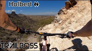
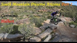
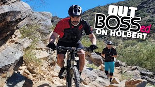
Holbert is a very technical steep trail full of boulders/drops/switchbacks and is not for the faint of heart. It is OTB central for inexperienced riders (OTB=Over The Bars crash)

Lower Holbert was rerouted in late 2023 as part of the Activity Complex reconstruction occurring in 2024/25. Map currently reflects new temporary trailhead and path to take around the fencing.

Trail Supporters
  • groaz
    Sponsor
  • Sponsor
Local Trail Association
Traditionally Indigenous Territory

Recent Activity on Trail

Past Week
  • 0 rides
  •  
6 Months
  • 4 rides
  • 18 miles avg distance
All
  • 20 rides
  • Last: May 2, 2026
c1c2c3c4
January
February
March
April
May
June
July
August
September
October
November
December
update trails status or condition

Holbert Trail Reports

Status:
on Apr 30, 2020
Dry
Avg: 4.1 (14 votes)
Your vote: 0

view (323)
close
3D
Trail Conditions
  • Unknown
  • Snow Groomed
  • Snow Packed
  • Snow Covered
  • Snow Cover Partial
  • Freeze/thaw Cycle
  • Icy
  • Prevalent Mud
  • Wet
  • Variable
  • Ideal
  • Dry
  • Very Dry
Trail Flow (Ridden Direction)
Trailforks scans users ridelogs to determine the most popular direction each trail is ridden. A good flowing trail network will have most trails flowing in a single direction according to their intension.
The colour categories are based on what percentage of riders are riding a trail in its intended direction.
  • > 96%
  • > 90%
  • > 80%
  • > 70%
  • > 50%
  • < 50%
  • bi-directional trail
  • no data
Trail Last Ridden
Trailforks scans ridelogs to determine the last time a trail was ridden.
  • < 2 days
  • < 1 week
  • < 2 weeks
  • < 1 month
  • < 6 months
  • > 6 months
Trail Ridden Direction
The intended direction a trail should be ridden.
  • Downhill Only
  • Downhill Primary
  • Both Directions
  • Uphill Primary
  • Uphill Only
  • One Direction
Contribute Details
Colors indicate trail is missing specified detail.
  • Description
  • Photos
  • Description & Photos
  • Videos
Trail Popularity ?
Trailforks scans ridelogs to determine which trails are ridden the most in the last 9 months. Trails are compared with nearby trails in the same city region with a possible 25 colour shades. Think of this as a heatmap, more rides = more kinetic energy = warmer colors.
  • most popular
  • popular
  • less popular
  • not popular
ATV/ORV/OHV Filter
Max Vehicle Width
inches
US Cell Coverage
Legend
cell carrier legend

Radar Time
Activity Recordings
Trailforks uses anonymized public activity data. ?
Activity Recordings
Trailforks uses anonymized public activity data. ?
Personal Heatmap
Activity Types
all / none
Options
2
Date range month
Winter Trails
Warning A routing network for winter maps does not exist. Selecting trails using the winter trails layer has been disabled.
Missing Trails
Most Popular
Least Popular
Trails are colored based on popularity. The more popular a trail is, the more red. Less popular trails trend towards green.
Jump Magnitude Heatmap
Heatmap of where riders jump on trails. Zoom in to see individual jumps, click circles to view jump details.
BC Backroad Status

Service Road Atlas is a free to use, community-driven service for viewing and creating reports on the numerous back-country service roads around B.C. and Alberta.

map legend
Slope Aspect
Direction the slope faces
Flat N NE E SE S SW W NW
Trails Deemphasized
Trails are shown in grey.
disable
Only show trails with no bike usage.
Enable
Suggested Layers
Based on selected activity type

    Save the current map location and zoom level as your default home location whenever this page is loaded.

    Save
        Directions to holbert trailhead (33.338520, -112.052400)

        Photos

        5 more »
        19 |
        Feb 9, 2026 @ 11:11am
        Feb 9, 2026
        239 |
        Feb 16, 2021 @ 3:51pm
        Feb 16, 2021
        227 |
        Feb 16, 2021 @ 3:51pm
        Feb 16, 2021
        271 |
        Feb 16, 2021 @ 3:51pm
        Feb 16, 2021

        Videos

        7 more »
        youtuber New Bike, New Trails, New Friends | Holbert...
        8:52 | 849 | Mar 26, 2022 , Phoenix
        youtuber Stufferoni, the South Mountain treat |...
        18:17 | 2283 | Mar 9, 2018 , Phoenix
        Holbert/Geronimo
        19:22 | 216 | Jul 11, 2023 , Phoenix
        youtuber Getting out BOSSed on Holbert, the most...
        17:48 | 263 | Aug 24, 2022 , Phoenix

        Routes with this trail

        3 miles 101 ft 2 Shuttled
        This is the way to via West from the parking lot. It can also be accessed from the road.
        5 miles 1,114 ft 2 Out & Back

        7 Reviews & Comments


        We hope you've been enjoying Trailforks!

        Create a FREE account to view trail comments and much more.

        Frequently Asked Questions About Holbert

        Where is Holbert located?
        Holbert is located in South Mountain Preserve, Phoenix, Arizona, United States. It is part of the South Mountain Preserve trail network. The trailhead is located at coordinates 33.33852, -112.0524.
        How hard is Holbert?
        Holbert is rated as Double Black Diamond difficulty. The physical rating is Hard. The average grade is 8.2%. The climb difficulty is rated Double Black Diamond.
        What is the elevation gain for Holbert?
        Holbert has 33 ft of elevation gain. The trail has 1,119 ft of elevation descent. The elevation ranges from 1,336 ft to 2,431 ft.
        Is Holbert a point to point trail?
        Yes, Holbert is a point to point trail. The direction is Downhill Only. The trail type is singletrack.

        Hit the Trail

        Open in App

        Get this trail on your phone instantly.
        open trail in app

        Download Trail

        Save to wishlist, Garmin & download.
        save the trail

        Find Related Routes

        Find routes and users activities that include this trail.
        find routes for this trail

        You must enter a description before submitting.