more stats
1,010 ft
Distance
2 ft
Climb
00:19:57
Avg time
4 ft
Altitude change
529 ft
Altitude min
533 ft
Altitude max
529 ft
Altitude start
531 ft
Altitude end
0.4%
Grade
-0.9%
Grade max
2.6%
Grade min
151 ft
Distance climb
62 ft
Distance down
741 ft
Distance flat
00:19:57
Avg time

Hollerback Trail Details

  • Activities
    • Mountain Bike
    • E-Bike
    • Hike
    • Trail Running
  • Riding Area
    Whiskey Run Trails
    Coos Bay, Oregon
  • Difficulty Rating
  • Local Popularity
    85 in Mountain Biking [+]
    • 80 in E-Biking
    • 95 in Trail Running
    • 90 in Hiking
  • Global Ranking
    #60766 in Mountain Biking [+]
    • #47144 in Trail Running
    • #47288 in Hiking
  • Trail Type
    Singletrack
  • Bike Type
    XC, Fat, CX
  • Direction
    Both Directions
  • Climb Difficulty
    Blue
  • Physical Rating
    Easy
  • Trail Visibility
    Always easy to follow
  • Family Friendly
    Yes
  • Dogs Allowed
    Yes
  • eBike Allowed
  • Year Opened
    2017
  • Land Owner
    Coos County Forest

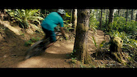
This trail is a green-blue with moderate climbs and flowing descents, but also has narrow sections, steep side slopes, tight trees, and punchy climbs. This cross-country flow style trail built to withstand the seasons and heavy use. The trail travels through different ages of timber harvests and around drainages/hollers. Access this trail from the Main parking lot via Hollerback Connector. If you want to start off with a fun downhill take a left onto Hollerback and continue down through Dirty Dishes to the bottom and climb up the west side at Sir Lance-A-Lot to the top. Ridden clockwise, there is still quite a bit of climbing from the top. To access the fun downhill rides on Sour Mash, White Lighting, and Bootlegger, ride Hollerback counter-clockwise to the top and choose your downhill. Watch for climbing traffic and steep side-slopes when riding this trail downhill.

Access Info

From the Main Parking lot off Whiskey Run Road, take the short Hollerback Access Trail and you'll meet up with Hollerback. From the lower parking lot at The Snag, ride up Dirty Dishes all the way until the 1st picnic bench at the intersection with Well Shot (downhill only) and Hollerback.

Trail Supporters
  • past supporters

Local Trail Association
Traditionally Indigenous Territory

Recent Activity on Trail

Past Week
  • 5 rides
  • 14 miles average
6 Months
  • 9 rides
  • 11 miles avg distance
All
  • 507 rides
  • Last: Jun 24, 2026
c1c2c3c4
January
February
March
April
May
June
July
August
September
October
November
December
update trails status or condition

Hollerback Trail Trail Reports

statusdatedescription
Sep 20, 2025 @ 11:03pm (America/Vancouver)
Sep 20, 2025
Aug 17, 2025 @ 10:05pm
Aug 17, 2025
Closed due to Road construction for Timber Ops
Jul 27, 2025 @ 1:10pm
Jul 27, 2025
Jul 4, 2025 @ 10:02am
Jul 4, 2025
Dec 23, 2024 @ 2:54pm
Dec 23, 2024
Cleared small low hangers and a small blow down.
more »
Status:
on Sep 20, 2025
Avg: 4.08 (5 votes)
Your vote: 0

view (1,741)
close
3D
Trail Conditions
  • Unknown
  • Snow Groomed
  • Snow Packed
  • Snow Covered
  • Snow Cover Partial
  • Freeze/thaw Cycle
  • Icy
  • Prevalent Mud
  • Wet
  • Variable
  • Ideal
  • Dry
  • Very Dry
Trail Flow (Ridden Direction)
Trailforks scans users ridelogs to determine the most popular direction each trail is ridden. A good flowing trail network will have most trails flowing in a single direction according to their intension.
The colour categories are based on what percentage of riders are riding a trail in its intended direction.
  • > 96%
  • > 90%
  • > 80%
  • > 70%
  • > 50%
  • < 50%
  • bi-directional trail
  • no data
Trail Last Ridden
Trailforks scans ridelogs to determine the last time a trail was ridden.
  • < 2 days
  • < 1 week
  • < 2 weeks
  • < 1 month
  • < 6 months
  • > 6 months
Trail Ridden Direction
The intended direction a trail should be ridden.
  • Downhill Only
  • Downhill Primary
  • Both Directions
  • Uphill Primary
  • Uphill Only
  • One Direction
Contribute Details
Colors indicate trail is missing specified detail.
  • Description
  • Photos
  • Description & Photos
  • Videos
Trail Popularity ?
Trailforks scans ridelogs to determine which trails are ridden the most in the last 9 months. Trails are compared with nearby trails in the same city region with a possible 25 colour shades. Think of this as a heatmap, more rides = more kinetic energy = warmer colors.
  • most popular
  • popular
  • less popular
  • not popular
ATV/ORV/OHV Filter
Max Vehicle Width
inches
US Cell Coverage
Legend
cell carrier legend

Radar Time
Activity Recordings
Trailforks uses anonymized public activity data. ?
Activity Recordings
Trailforks uses anonymized public activity data. ?
Personal Heatmap
Activity Types
all / none
Options
2
Date range month
Winter Trails
Warning A routing network for winter maps does not exist. Selecting trails using the winter trails layer has been disabled.
Missing Trails
Most Popular
Least Popular
Trails are colored based on popularity. The more popular a trail is, the more red. Less popular trails trend towards green.
Jump Magnitude Heatmap
Heatmap of where riders jump on trails. Zoom in to see individual jumps, click circles to view jump details.
BC Backroad Status

Service Road Atlas is a free to use, community-driven service for viewing and creating reports on the numerous back-country service roads around B.C. and Alberta.

map legend
Slope Aspect
Direction the slope faces
Flat N NE E SE S SW W NW
Trails Deemphasized
Trails are shown in grey.
disable
Only show trails with no bike usage.
Enable
Suggested Layers
Based on selected activity type

    Save the current map location and zoom level as your default home location whenever this page is loaded.

    Save
        Directions to hollerback-trail trailhead (43.225140, -124.338580)

        Photos

        23 more »
        814 |
        Jun 6, 2019 @ 11:10am
        Jun 6, 2019
        557 |
        May 31, 2018 @ 3:27pm
        May 31, 2018
        93 |
        Apr 9, 2023 @ 8:07pm
        Apr 9, 2023
        85 |
        Apr 2, 2023 @ 9:32pm
        Apr 2, 2023

        Videos

        2 more »
        Mountain BIKING with my two LITTLE Girls ||...
        15:55 | 356 | Mar 30, 2022 , Coos Bay
        Whiskey Run
        3:03 | 9063 | Jun 6, 2019 , Coos Bay

        Routes with this trail

        5.0 11 miles 1,446 ft 18 Loop
        This Intermediate 11+ mile loop is a great sampling of blue and green trails in the Whiskey Run Trail...
        3.5 7 miles 658 ft 30 Loop
        This route was offered as a guided ride at the Whiskey Run Trails opener June 9, 2017. During this time,...
        5.0 12 miles 1,100 ft 18 Loop
        This is the Full Flight Course (Classic/Phase 1) for the Whiskey Run Mountain Bike Trails opening...

        Trail Events

        2 Reviews & Comments


        We hope you've been enjoying Trailforks!

        Create a FREE account to view trail comments and much more.

        • By whiskeyqueenTF Pro & contributors
        • #112023 - 3,649 views

        Frequently Asked Questions About Hollerback Trail

        Where is Hollerback Trail located?
        Hollerback Trail is located in Whiskey Run Trails, Coos Bay, Oregon, United States. It is part of the Whiskey Run Trails trail network. The trailhead is located at coordinates 43.22514, -124.33858.
        How hard is Hollerback Trail?
        Hollerback Trail is rated as Green difficulty. The physical rating is Easy. The average grade is 0.4%. The climb difficulty is rated Blue.
        What is the elevation gain for Hollerback Trail?
        Hollerback Trail has 2 ft of elevation gain. The elevation ranges from 529 ft to 533 ft.
        Is Hollerback Trail a point to point trail?
        Hollerback Trail is not a point to point trail. The direction is Both Directions. The trail type is singletrack.

        Hit the Trail

        Open in App

        Get this trail on your phone instantly.
        open trail in app

        Download Trail

        Save to wishlist, Garmin & download.
        save the trail

        Find Related Routes

        Find routes and users activities that include this trail.
        find routes for this trail

        You must enter a description before submitting.